Bell Arts Factory in Ventura

Bell Arts Factory at 432 N. Ventura Avenue, Studio 101, Ventura was created in October 2004 with the decision to transform a historic 20,000 square foot mattress factory on Ventura Avenue into a vibrant, mixed-use community arts center.

Artists, poets, crafters, dance and arts instructors, as well as city and community groups, are all making creative and active use of the 2,000 square foot Janet Addison Community Room for programs, meetings, performances and exhibitions.

More information at bellartsfactory.org.

Arroyo Simi Bike Path in Simi Valley

The Arroyo Simi Bike Path is a two lane bike path in Simi Valley that runs from Madera Road, just south of Easy Street on the west, ending at Cochran Avenue between Fig Street and Ralston Street on the east (more recently, the path has been extended east to Tapo Street).

Over seven miles in total. It is also referred to as the Arroyo Simi Greenway.

The Arroyo Simi is a waterway that begins at Corriganville Park in east Simi Valley and extends west all the way through Simi Valley until into merges into Arroyo Las Posas and Conejo Creek into Calleguas Creek. It is managed by the County of Ventura but the Rancho Simi Recreation and Park District has access to the pathway for recreational use.

While this path is nowhere near as visually appealing as bike paths along Ventura Beach and such, the Arroyo Simi Bike Path is almost entirely flat and allows passageway along much of Simi Valley from east to west. You can really do a lot of exploration from this artery. We like to park at the East Street entry point and bike to Rancho Simi Community Park (2.2 miles one way), Rancho Santa Susana Park (6 miles one way) and various other areas.

Because this path is so long and flat (and not crowded), it is a nice destination for learning to ride. However, do be aware that there are a number of street crossings where you are asked to walk your bike across. They are protected by lights and signs, however.

Arroyo Simi bike path entry point at Easy Street and Madera.

Arroyo Simi bike path entry point at Easy Street and Madera.

Arroyo Simi Bike path may not be the most picturesque path but is nicely flat and goes a long way!

Arroyo Simi Bike path may not be the most picturesque path but is nicely flat and goes a long way!

There are numerous entry points to the path, which largely parallels Los Angeles Avenue; this one is just east of Ralston off of Los Angeles Avenue.

There are numerous entry points to the path, which largely parallels Los Angeles Avenue; this one is just east of Ralston off of Los Angeles Avenue.

Santa Susana Depot Museum and Model Railroad in Simi Valley

SantaSusana_pic1.JPG

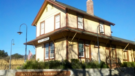
Visit a fully restored Southern Pacific Railroad depot that was built in 1903 with both freight and passenger trains rushing by at the Santa Susana Depot Museum and Model Railroad. The depot served passengers and farmers in Simi Valley for over 60 years, with a classic passenger waiting room featuring a pot-belly stove, the depot was also headquarters for local freight shipments.

The depot is a museum filled with hundreds of items having both railroad and local historical significance. The depot is owned and managed by the Rancho Simi Recreation and Park District, which took it over from the Southern Pacific Railroad in 1973. The depot was moved to its current location and after 10 years of neglect was restored to its current state by 1996. The depot was restored to what it looked like in 1938.

Also at the depot is the Santa Susana Model Railroad Club’s large operating HO scale model railroad. Located inside the depot's freight room, the layout of the railroad portrays Simi Valley during the mid 1950s. Trains run each weekend, with Sundays being the best day to see several trains operating simultaneously.

The depot is located on the grounds of Simi Valley’s beautiful Oak Knolls Park. For you rail fans, the depot is adjacent to the Union Pacific Railroad’s busy “Coast Line,” which is also utilized by both Amtrak and Metrolink passenger trains. You will standing in close proximity to passing trains, so get ready to wave!

The depot is located at 6503 Katherine Road in Simi Valley. For more information and a map to the depot/parking, visit www.santasusanapacific.org or call 805.581.3462.  The depot is open on Saturdays and Sundays from 1 pm to 4 pm.

SantaSusanaDepot.jpg
SantaSusana_pic2.JPG
SantaSusana_pic.jpg
SantaSusana_pic4.jpg

Ventura Harbor Village

VentHarborVillage2.jpg

Ventura Harbor Village at 1583 Spinnaker Drive, Ventura is home to 33 acres of harborside activities, shopping and restaurants.  The weather is always so cool over there it makes for a nice retreat.

Go for a walk along the boardwalk or at the beach or enjoy activities like kayaking, sailing, pedal boats, sport-fishing and cruises. Ventura Harbor Village hosts events and activities year-round, including music performances, kids' activities, themed events, festivals and more.

VentHarborVillage1.JPG
VentHarborVillage3.jpg

Eateries at Ventura Harbor Village include Andria's Seafood Restaurant, Baja Bay Surf N' Taco, Boatyard Pub, Brophy Bros. Clam Bar & Restaurant, Coastal Cone Ice Cream, Deep Sea Wine Tasting Room, Le Petit Cafe, Bakery & Restaurant, Margarita Villa Mexican Restaurant, On The Alley, Sugar Lab Bake Shop, The Greek Mediterranean Steak & Seafood and The Parlor. You won't go hungry here.

The Channel Islands National Park Visitor Center is located adjacent to Ventura Harbor Village. Free admission and an awesome resource for learning more about the Channel Islands and its protected habitat.

Island Packers at the Harbor has numerous boat rides and is the only authorized concessionaire to transport folks to Channel Islands National Park. 

Ventura Boat Rentals rents out electric boats, paddle boats, kayaks, power boats and charters cruises in the Ventura Harbor.  So much fun to be had!

VHarbor Kayaking.jpg

Across the street from Ventura Harbor Village is beach access at Harbor Cove Beach (a safe beach protected by jetties) and Surfer's Knoll Beach. Local area beaches at THIS LINK.

More information at www.venturaharborvillage.com or call 805.642.8538 (or 877.89.HARBOR).

Spring Canyon Trail Hike in Thousand Oaks

The Spring Canyon Trail is a short, fairly easy hike in the Newbury Park/Thousand Oaks section of the Los Robles Trail system that is great family fun.

Although a good portion of the Spring Canyon Trail is flat like this, there definitely are some moderately hilly sections.

Although a good portion of the Spring Canyon Trail is flat like this, there definitely are some moderately hilly sections.

This one mile trail runs east from the vicinity of Lynn Oaks Park, 359 Capitan Street, Newbury Park as well from the eastern terminus of Hemlock Lane, at Heavenly Valley Road in Newbury Park (in the Ventu Park community) to a juncture where you can either continue straight ahead for about a half a mile towards the Los Robles Trail access point at South Moorpark Road and Greenmeadow Avenue in Thousand Oaks or veer up "Space Mountain" on the right. (The views at the top of Space Mountain are awesome but this is a bit of a climb and is very popular with mountain bikers...probably not the best direction with little ones).

The path that takes you from Lynn Oaks Park to the Spring Canyon Trail.

The path that takes you from Lynn Oaks Park to the Spring Canyon Trail.

Sign above Lynn Oaks Park that tells you that to the left is Los Robles Trail and to the right is the Hemlock Lane gate in Ventu Park.

Sign above Lynn Oaks Park that tells you that to the left is Los Robles Trail and to the right is the Hemlock Lane gate in Ventu Park.

Out and back you can make this a 2 to 3 mile moderate hike or more if you add in the Oak Creek Canyon Loop or Los Robles Nature Walk.

Sign at the east terminus of Spring Canyon Trail indicating Moorpark Road is half a mile away. Behind me is the trail toward "Space Mountain" and Los Robles Trail going east towards Newbury Park.

Sign at the east terminus of Spring Canyon Trail indicating Moorpark Road is half a mile away. Behind me is the trail toward "Space Mountain" and Los Robles Trail going east towards Newbury Park.

You can also park your car at the Moorpark Road/Greenmeadow trailhead and make your way west towards the Spring Canyon Trail and perhaps eat lunch or snack at Lynn Oaks Park (which by the way also has a nice playground area, basketball court and more...but no restroom however).

Sunset Hills Trail in Thousand Oaks

SunsetHillsTrail_sign.JPG

The Sunset Hills Trail is easily accessible off of Erbes Road in Thousand Oaks, just 7/10ths of a mile north of Sunset Hills Boulevard, just past Fernleaf Court.

There's a triangular dirt parking lot on the east.

There's a triangular dirt parking lot on the east.

This is a pretty easy mile or so trail that takes you past the Bard Lake Reservoir. The reservoir is of course is fenced in but you'll be treated to its beauty as you make your way up. Lake Bard is owned by the Calleguas Water District for storage of up to 10,000 acre-feet (3.3 billion gallons) of water used to meet peak summer demand and emergency requirements.

SunsetHillsTrail2.JPG

In fact, most all the way up this fairly gentle, hilly slope, you'll get some great panoramic views of the entire area, including the Conejo Valley, Simi Hills and looking west towards Camarillo/Oxnard. Continue east and you will reach the Woodridge Open Space in Thousand Oaks.

SunsetHillsTrail1.JPG
SunsetHillsTrail4.JPG

The Sunset Hills Trail is maintained by the Conejo Open Space Foundation. More information at cosf.org/trails/other-trails/easy-hike-sunset-hills-trail.

SunsetHillsTrail5.JPG

An additional, and perhaps more popular hike provides even better view of the Bard Reservoir. Take the additional loop in the shape of Maine (kind of) either clockwise or from the first juncture or counterclockwise after cresting the hill. If you go to the top of the hill take the trail on the left and continue onwards. You will see some steps and a bench to take in the views along the way.

(Map courtesy of the conejo Open Space Foundation) Green highlighted section is a nice loop to hike - good family hike.

After cresting the first hill from Erbes Road, find the loop trail on the left.

After cresting the first hill from Erbes Road, find the loop trail on the left.

A short walk to this bench that overlooks Bard Reservoir.

A short walk to this bench that overlooks Bard Reservoir.

Continue on the trail until it loops around and goes south., parallel to Highway 23

Continue on the trail until it loops around and goes south., parallel to Highway 23

Soon you will be back at the main trail, passing through this tree-tunneled section.

Soon you will be back at the main trail, passing through this tree-tunneled section.

Libbey Bowl and Libbey Park in Ojai

Libbey Bowl and Libbey Park are located in the heart of Ojai near the corner of Ojai Avenue and Signal Street. Libbey Bowl was originally built in 1957 and has been used for the annual Ojai Music Festival, Storytelling Festival, Ojai Day event, holiday celebrations and many other community events through the years. Beginning in 2008, the bowl was renovated and in 2011 was reopened with a new look and design. It accommodates 1,300 people. Learn more about Libbey Bowl at www.libbeybowl.org.

Both Libbey Bowl and Libbey Park are named after Ojai's greatest benefactor, Edward Libbey, a glass manufacturer from Toledo, Ohio. Libbey donated the park to the city in 1917. In front of the park is a shaded pergola along the main "arcade" section of Downtown Ojai.

The park contains a community playground that was designed and built with the help of over 500 volunteers in 2015.

This is a photo of the OLD play structure that was replaced in October 2015.

This is a photo of the OLD play structure that was replaced in October 2015.

The new playground!

The new playground!

There are also plenty of benches and seating areas, restrooms, shade trees and tennis courts at Libbey Park. Learn more on the City of Ojai website at www.ojairec.com/460/Libbey-Park.

Conejo Players Theatre in Thousand Oaks

The Conejo Players is a community based theatre arts group that has entertained local residents since 1958.  It is a volunteer based non-profit organization that hosts six productions each year, as well as several productions geared towards kids.

The 185 seat Conejo Players Theatre is located at 351 South Moorpark Road in Thousand Oaks, just south of the 101 near the Los Robles Greens entrance.  Phone is 805.495.3715.  www.conejoplayers.org

Bank of America Performing Arts Center Thousand Oaks

The Bank of America Performing Arts Center (BAPAC) Thousand Oaks (formerly the Thousand Oaks Civic Arts Plaza) is one of the largest performing arts centers between Los Angeles and San Francisco at over 200,000 square feet.

CivicArtsPlaza.JPG

The City of Thousand Oaks Cultural Affairs Department oversees theatre productions for the BAPAC, which encompasses two theatres – the 1,800-seat Fred Kavli Theatre and the 394-seat Janet and Ray Scherr Forum Theatre.

The performing arts center combines outstanding arts and entertainment with state-of-the-art technology and acoustics. Over 300,000 patrons and 50,000 children attend more than 400 performances annually. The BAPAC Thousand Oaks is funded through a unique public/private partnership between the City of Thousand Oaks and the Alliance for the Arts. It opened in 1994.

Thousand Oaks Civic Arts Plaza

Thousand Oaks Civic Arts Plaza

There is something for everyone at this venue....musicals, cabaret, Broadway musicals, dance, concerts, big bands, the New West Symphony, ballet, plays, well known speakers and events for the kids. In front of the plaza is the Mary and Richard Carpenter plaza park.

Next door to the Plaza is The Lakes of Thousand Oaks, a great place to grab a bite to eat, do some shopping and enjoy the lakes and playground on the property.

Between 1926 and 1968 this location housed the 170 acre Goebel's Lion Farm (later called Jungleland), where many of the famous wild animals in Hollywood pictures lived.  There were elephants, lions, tigers, hippos, you name it.  Leo, the MGM lion, Mr. Ed the Talking Horse, and Getta, Tarzan's chimpanzee all lived there at some point.  Jungleland was a major draw in its day that played a large role in making Thousand Oaks what it is today.

A photo of Jungleland after it closed in 1969 (Image courtesy of Conejo Through the Lens, Thousand Oaks Library).

A photo of Jungleland after it closed in 1969 (Image courtesy of Conejo Through the Lens, Thousand Oaks Library).

The BAPAC is located at 2100 E. Thousand Oaks Boulevard (take the 101 East, left on Rancho exit, right on T.O. Blvd, and turn right into parking structure at Dallas Drive).  Visit bapacthousandoaks.com for more information or call 805.449.2787.

It takes good luck and timing for a novice photographer like me to capture the Thousand Oaks Civic Arts Plaza while driving south on the 101 freeway.

It takes good luck and timing for a novice photographer like me to capture the Thousand Oaks Civic Arts Plaza while driving south on the 101 freeway.

TOCivicArtsPlaza_wall.JPG

Color Me Mine Paint Your Own Ceramics Studio in Oxnard

ColorMeMine_logo.jpg

Are you looking for a creative way to spend quality time with the ones you love? Paint ceramics with your friends and family at Color Me Mine Paint Your Own Ceramics Studio located at The Collection at Riverpark, at 2710 Portico Way, Oxnard!

Color Me Mine is a ceramic painting studio where you drop by anytime and paint a pre-made bisque pieces. For the price of a studio fee and the item you choose to paint, you can paint all day using 60+ colors and supplies! They then glaze and fire your work in a kiln and your work of art will be available in 5 to 7 days.

In addition to a vast array of tableware, painters can select from a variety of vases, frames, jewelry boxes, figurines, and more!

More information at www.oxnard.colormemine.com or call 805.981.8631.

CReATE STUDIO Mobile Art Studio

CReATE STUDIO originally opened at a venue in Westlake Village in 2009 but is now a mobile art studio geared towards creative exploration using a varied array of recycled, artistic and crafty materials. All ages can create treasured masterpieces using many interesting and everyday household materials to build, tape, glue, paint and invent!

To learn more, visit www.createstudiofun.com.

Malibu Lagoon State Beach

Malibu Lagoon State Beach is where Malibu Creek meets the Pacific Ocean. To get there, park either at the state lot (corner of Pacific Coast Highway and Cross Creek Road) for a fee, along Pacific Coast Highway or across the street in spots available near Malibu Country Mart and the Malibu Civic Center.

The lagoon is serene, with a sandbar of pelicans enjoying their summer day. This beach extends southeast to Surfrider Beach and the Malibu Pier, which is just a short walk away. While you're there try to check out the Adamson House and Malibu Lagoon Museum.

More information at www.parks.ca.gov/?page_id=835. Dogs are not allowed at Malibu Lagoon State Beach and trails.

MalibuLagoon1.5.JPG
MalibuLagoon2.JPG
MalibuLagoon3.JPG
MalibuLagoon4.JPG

Rancho Sierra Vista / Satwiwa in Newbury Park

RanchoSierraVistaEntry.jpg

We are fortunate to have such great trails and views of Boney Peak from in Newbury Park. At Wendy and Potrero is the Western edge of the Santa Monica Mountains where Sycamore Canyon cuts through Rancho Sierra Vista/Satwiwa and Point Mugu State Park.

SatwiwaSign.JPG
Satwiwa.jpg

Roughly a mile easy hike from Wendy/Potrero gets you to the Satwiwa Native American Indian Culture Center where you can explore some native Chumash items and educational information and chat with rangers. This is a nice little hike to take the kids on. There are restrooms and water at the center, which is open from 9 to 5 on weekends.

Learn more about hiking in Rancho Sierra Vista/Satwiwa at THIS LINK.

You can get easier access to the center by parking in the adjacent National Park Service parking lot via Lynn Road to the access road at Via Goleta in Newbury Park.

Another mile and a half of hiking gets you to a small waterfall, which is fun to check out with the kids but somewhat more strenuous of a hike. Note that in recent years (2012-2015), the waterfall has barely flowed due to low rainfall.

Here is more information about the Boney Mountain Trail, leading up to Hidden Valley Overlook, the waterfall and Danielson Monument.

SatwiwaCircle.JPG

Visit www.nps.gov/samo/planyourvisit/rsvsatwiwa.htm for a map and site information on the National Park Service website.

BoneyViewsSatwiwa.jpg
SatwiwaTrails.JPG
WendyPotreroTrailhead.JPG

Trailhead at the corner of Wendy Drive and Potrero Road in Newbury Park. Park on the dirt on the south side of Potrero or on the street on Wendy.