Levity Live Comedy & Dinner Theater Coming to The Collection at RiverPark in Oxnard

When it comes to having a good laugh nothing beats live comedy, and Levity Live Comedy & Dinner Theater at The Collection at RiverPark is Oxnard's place to catch top stand-ups throughout the week. Whether it's SNL legends like Kevin Nealon and Jon Lovitz; stars of TV and film like Craig Robinson, Mo'Nique and Jay Mohr; or hot national headliners like Ralphie May, Bobby Lee and Carlos Mencia, Levity Live brings the funniest comics around to the stage. The club also features a full restaurant and cocktails galore, so you can make a night of it. Learn more at oxnard.levitylive.com/calendar.

DISCOUNTED TICKETS TO UPCOMING LEVITY LIVE SHOWS AT GOLDSTAR.COM

Fossil Trail Loop Hike in Point Mugu State Park

If you have two to three hours to spare and are looking to do about six miles of strenuous local hiking, consider trying the Fossil Trail loop in Point Mugu State Park, starting at the adjacent Rancho Sierra Vista/Satwiwa managed by the National Park Service in Newbury Park . If you're looking for a FLAT hike, this one isn't for you! Click the image below for detailed information and photos.

Chumash Trail in Simi Valley

The Chumash Trail in Simi Valley is a roughly 2.7 mile trail that takes you from near Chumash Park to the trailhead at the north end of Flanagan Drive to the Rocky Peak Trail. It is a moderate, uphill trail with plenty of views of Simi Valley. No trees and thus no shade. Dogs allowed on leash.

To get to the Chumash Trail trailhead, take the 118 to Yosemite, go north, turn right on Flanagan to the end. Park on the street. More information at www.rsrpd.org/simi_valley/trails/chumash_park_and_trail.php.

Sandstone formations appear on the upper portion of the trail.

Sandstone formations appear on the upper portion of the trail.

Carpinteria Valley Museum of History

CarpHistMuseum.jpg

The Carpinteria Valley Museum of History hosts exhibits that reflect the histories of the three cultures that have dwelled in the region: the Chumash people; Spanish and Mexican settlers; and the pioneers. On display are historical photographs that reflect the development of the region as well as artifacts left behind by former inhabitants.

General Admission is free, donations are appreciated. Suggested donations: Adults: $2; Seniors and Children: $1

Exhibit Gallery Hours: Tuesday – Saturday, 1:00 – 4:00 PM. (Closed Sundays, Mondays and major holidays.)

Visit www.carpinteriahistoricalmuseum.org for more information. Located at 956 Maple Avenue, Carpinteria.

Red Tile Walking Tour in Santa Barbara

The Red Tile Walking Tour in Santa Barbara is an informal, 12 block walk in the downtown area that will take you past a variety of Santa Barbara historical landmarks. It was originally developed by the Santa Barbara Chamber of Commerce. The walk is summarized below but visit Santa Barbara Car Free website at www.santabarbaracarfree.org for additional details and a printable map.

  1. Santa Barbara County Courthouse (Built in 1929)
  2. Public Library
  3. Santa Barbara Museum of Art
  4. Hill-Carrillo Adobe
  5. El Paseo
  6. Casa De La Guerra
  7. Plaza De La Guerra
  8. Orena Adobes
  9. Presidio Avenue (the oldest street in Santa Barbara)
  10. Lugo Adobe
  11. Santa Barbara Historical Museum
  12. Casa Covarrubias
  13. Rochin Adobe
  14. El Presidio de Santa Barbara State Historic Park
  15. El Cuartel (second oldest surviving building in California)
  16. Main Post Office
  17. Lobero Theatre

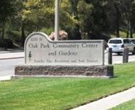
Oak Park Community Center and Gardens

OakParkCommCtr.jpg

Oak Park Community Center and Gardens is located at 1000 North Kanan Road, Oak Park. This is a nicely appointed indoor/outdoor facility with a 2,500 sq ft banquet room with a capacity of 140, a half court gym and recreation room and as you can see in this video, a beautifully maintained pond, waterfall, gazebo and outdoor area.  Plenty of parking available too. More information at www.rsrpd.org/oak_park/community_center/index.php or call 818.865.9304.

Santa Barbara Audubon Aviary

EyesInTheSky.png

Eyes in the Sky (EITS) is an education program with the Santa Barbara Audubon Society (SBAS) that brings a variety of programs to children and adults in the Santa Barbara area. EITS features wildlife messengers - birds of prey native to the area that are no longer capable of surviving in the wild. 

The SBAS has teamed with the Santa Barbara Museum of Natural History (2559 Puesta del Sol, Santa Barbara) to build the Santa Barbara Audubon Aviary, a physical structure located in the "backyard" area of the Museum. The Aviary is open every afternoon between 2 and 4PM. During this time, volunteers bring the birds out for exercise, sunshine, misting/baths and close up encounters with visitors.  We have seen these animals up close and they are quite impressive!

For more information, visit www.eyesinthesky.org.

AudubonAviary_building.JPG
AudubonAviary.JPG
AudubonOwl.JPG
Kisa the Peregrine Falcon

Kisa the Peregrine Falcon

Palo Comado Canyon to Simi Peak Hike in Oak Park

If you're looking for a challenge, consider hiking from the Palo Comado Canyon Doubletree Road Trailhead to the 2,405 foot elevation Simi Peak in Oak Park. This is about a 4 to 4 1/2 mile trek each way with a 1,200 foot elevation gain to the top that is well worth it if you have the time and the energy.

Mind you, this particular stretch of trail, the Palo Comado Fire Road, I've rarely seen more than a handful of hikers and runners on over the years. I usually see more cyclists up here than anything. Part of the challenge is that it can get pretty hot up here on these trails as most of them get full exposure to the sun. So do bring plenty of water and wear sunscreen unless it happens to be a rare, overcast day. No restrooms either.

A quicker, easier path to the panoramic Simi Peak, the highest point in the Simi Hills, is via the China Flat Trailhead.

So if you're up to the challenge, park your car near the trailhead on Doubletree Road , just east of Clear Haven Drive, in Oak Park. From the 101, take Kanan to Sunnycrest Drive, and make a right. Sunnycrest becomes Doubletree after it veers left. The trailhead is on the right.

About a half mile from the trailhead gets you to the Palo Comado Canyon Trail, where you'll head north (left).

About a half mile from the trailhead gets you to the Palo Comado Canyon Trail, where you'll head north (left).

The Palo Comado Canyon Trail is fire road, so it is nice and wide.

The Palo Comado Canyon Trail is fire road, so it is nice and wide.

Eventually, after a bit of a grueling climb (this hike is not kid friendly if you ask me), you'll reach this corral area. Continue west (left).

Eventually, after a bit of a grueling climb (this hike is not kid friendly if you ask me), you'll reach this corral area. Continue west (left).

Follow the direction of the signs toward the Simi Peak Trail and you're on your way.

Follow the direction of the signs toward the Simi Peak Trail and you're on your way.

Follow the direction of the sign towards Simi Peak. The only challenge is that you have to go with your gut at some point as the signs stop.

Follow the direction of the sign towards Simi Peak. The only challenge is that you have to go with your gut at some point as the signs stop.

The trails get narrower and a bit more technical as you head your way to the peak. Wear good shoes.

The trails get narrower and a bit more technical as you head your way to the peak. Wear good shoes.

You've reached your destination when you see this.

You've reached your destination when you see this.

You are now at Simi Peak, the highest point of the Simi Hills. The round marker on the right is from the Ventura County Surveyor. In background is Lindero Canyon Road headed south.

You are now at Simi Peak, the highest point of the Simi Hills. The round marker on the right is from the Ventura County Surveyor. In background is Lindero Canyon Road headed south.

Fancy, green highlighted map (courtesy National Park Service).

Grandma Prisbrey's Bottle Village in Simi Valley

Grandma Prisbrey's Bottle Village in Simi Valley is a California Historical Landmark, Ventura County Cultural Landmark, is listed on the National Register of Historic Places and has a historic designation from the city of Simi Valley. CLICK HERE to learn more and to see more photos here on CVG.

BottleVillage13.JPG

Serra Retreat in Malibu

The Serra Center sign as seen from Pacific Coast Highway

The Serra Center sign as seen from Pacific Coast Highway

The Serra Retreat is a Catholic retreat and conference center located in the hills of Malibu on a 26 acre knoll, across the street from the Malibu shoreline. The location, since 1943, has welcomed church groups, schools, non-profits and other organizations a quite space for retreats and workshops.

Courtyard area facing the Pacific Ocean

Courtyard area facing the Pacific Ocean

During the week, the public is allowed to visit the grounds between 9 am and 4:30pm for personal prayer and reflection. No reservations are required. You must stop at the guard gate, located on Serra Road at PCH, about a 1/4 mile east of Cross Creek Road, obtain a guest pass, then slowly drive up Serra Road, for about a mile until you seen the turnoff on to the Retreat on the left. The actual address of the facility is 3401 Serra Road, Malibu.

Parking pass received at guard gate

Parking pass received at guard gate

There are no public restrooms at the facility and dogs are not allowed, nor or picnic lunches. This is a place for reflection, not to mention taking in the great views. There are a number of benches to reflect as you look down below as you enjoy paths and walkways and enjoy the gardens and sights. There is also a stone lined labyrinth for walking and reflection. 

Labyrinths are always cool, both to look at and to walk.

Labyrinths are always cool, both to look at and to walk.

You can get married here too, with two locations to celebrate after the ceremony. Capacity is 120 guests.

Learn more at serraretreat.com.

The view is not too shabby either!