Disneyland Park in Anaheim

Everyone knows about Disneyland Park (originally called just Disneyland) in Anaheim, so here in this post we will summarize some key tidbits about this amusement park.

Disneyland Park and sister theme park Disneyland California Adventure together form Disneyland Resort, along with three hotels (Disneyland Hotel, Disney's Grand Californian Hotel & Spa and Disney's Paradise Pier Hotel) and Downtown Disney, an outdoor shopping and restaurant area connecting the theme parks and hotels.

Disneyland Park Sections (or "Lands")

Disneyland is divided into the following "lands," or themed sections: Main Street, U.S.A., Adventureland, New Orleans Square, Frontierland, Critter Country, Fantasyland, Mickey's Toontown and Tomorrowland.  Ground breaking for a new section, "Star Wars Land," began in April 2016. Star Wars Land will encompass 14 acres when completed at a future date.

The eight existing lands occupy 85 acres. The original lands when Disneyland opened on July 17, 1955 were Main Street U.S.A, Adventureland, Frontierland, Fantasyland and Tomorrowland. Later on came New Orleans Square (1966), Bear Country (later changed to Critter Country) in 1972 and Mickey's Toontown in 1993.

The "lost" land is Holidayland, which opened in 1957, a 9 acre area with a circus and baseball diamond, that closed in 1961. (Good to know this, trivia buffs!)

Disneyland Park Attractions by Land

Visit touringplans.com/disneyland-resort/closures for updates on rides that are closed for renovation.

Opening May 31, 2019: Star Wars: Galaxy’s Edge: Millennium Falcon: Smugglers Run

  • 14 acre expansion of Disneyland

  • Opening later this year: Star Wars: Rise of the Resistance

  • Reservations required from May 31 to June 23, 2019

Main Street U.S.A: The Disney Gallery, Disney’s "Aladdin” Sneak Peak, Main Street Cinema and Main Street Vehicles (turn of the 20th century vehicles)

Adventureland: Enchanted Tiki Room, Indiana Jones Adventure, Jungle Cruise, Tarzan's Treehouse

Critter Country: Davy Crockett's Explorer Canoes, The Many Adventures of Winnie the Pooh, Splash Mountain

Frontierland: Big Thunder Mountain Railroad, Frontierland Shootin' Expedition, Mark Twain Riverboat, Pirate's Lair on Tom Sawyer Island, Sailing Ship Columbia

  • Frontierland, representing the “Frontiers of America,” opened as on of five original lands on July 17, 1955.

  • Big Thunder Trail is a walkway between Frontierland and Fantasyland and also serves as one of the entrances to Star Wars: Galaxy’s Edge.

  • Big Thunder Mountain Railroad’s 40th anniversary is September 2, 2019

  • Eateries in Frontierland include The Golden Horseshoe and Stage Door Cafe for quick service options and Rancho del Zocalo Restaurant (Mexican food) and River Belle Terrace (comfort food) for sit down and dine options.

Fantasyland: Alice in Wonderland, Casey Jr. Circus Train, Dumbo the Flying Elephant, King Arthur Carrousel (yes, this 1955 original ride is spelled with two r's), Mad Tea Party, Matterhorn Bobsleds, Mr. Toad's Wild Ride, Peter Pan's Flight, Pinocchio's Daring Journey, Sleeping Beauty Castle Walkthrough, Snow White's Scary Adventures, Storybook Land Canal Boats, “it's a small world”

Mickey's Toontown: Chip 'n Dale Treehouse, Donald's Boat, Gadget's Go Coaster, Goofy's Playhouse, Mickey's House and Meet Mickey, Minnie's House, Roger Rabbit's Car Toon Spin

New Orleans Square: Haunted Mansion, Pirates of the Caribbean

Tomorrowland: Astro Orbitor, Autopia, Buzz Lightyear Astro Blasters, Disneyland Monorail, Finding Nemo Submarine Voyage, Space Mountain Ghost Galaxy, Star Tours - The Adventures Continue, Star Wars Launch Bay, Star Wars: Path of the Jedi

Various Areas: Disneyland Railroad

Character Experiences and Live Entertainment

There are various opportunities to meet Disney characters throughout the park. Visit disneyland.disney.go.com/entertainment/#/character-experiences for details. And for live entertainment opportunities, visit disneyland.disney.go.com/entertainment.

Pricing

Retail pricing is as follows as of May 2019 and of course is subject to change:

  • 1-Day, 1 Park: Varies from $104 (Value) to $129 (Regular) to $149 (Peak) (For Ages 10+; Ages 3 to 9 are about $6 less per ticket)

  • 2-Day, 1 Park Per Day: $225 or Park Hopper $280

  • 3-Day, 1 Park Per day: $300 or Park Hopper $355

  • 4-Day, 1 Park Per Day: $325 or Park Hopper $380

  • 5-Day, 1 Park Per Day: $340 or Park Hopper $395

  • Annual Passports: There are 5 to choose from and they vary from $399 to $1,399 per year. The $1,399 Disney Signature Plus Passport gets you in to both park every day of the year.

  • One Day Parking: $25

Learn more at disneyland.disney.go.com.

Ventura County Wine Trail

VCWineTrail.jpg

Ventura County Wine Trail offers 14 family-owned, award winning wineries right here in Ventura County and adjacent areas! Unique wine tasting tours, five star restaurants, luxury hotels, wine events and attractions, make an amazing wine country destination getaway.

Visit www.venturacountywinetrail.com.

Here are the 14 wineries (updated April 2019) that are part of this trail.

Alma Sol Winery in Thousand Oaks www.almasolwinery.com

Back Patio Cellars in Camarillo www.backpatiocellars.com

Boccali Vineyards and Winery in Ojai www.boccalivineyards.com

Camarillo Custom Crush Winery www.camarillocustomcrush.com

Clos des Amis in Ventura www.closdesamis.com

Herzog Wine Cellars in Oxnard www.herzogwinecellars.com

Labyrinth Winery and Tasting Room in Ventura www.LabyrinthWinery.com

Magnavino Cellars in Oxnard www.magnavino.com

Malibu Sundowner in Westlake Village www.malibusundownerwines.com

Millesime Cellars in Camarillo www.millesimecellars.com

Panaro Brothers Winery in Ventura www.panarobrotherswinery.com

Rancho Ventano Cellars in Oxnard www.ranchoventavo.com

Strey Cellars in Oxnard www.StreyCellars.com

Sunland Vintage Winery and Tasting Room in Thousand Oaks www.SunlandVintageWinery.com

ImmotionVR at The Oaks Shopping Mall in Thousand Oaks

ImmotionVR.jpg

We were just passing through The Oaks mall recently when we looked up and saw ImmotionVR on the first floor near Aveda. ImmotionVR offers up virtual reality experiences for $8 per ride (5-8 minutes), $25 for 30 minutes and $40 for 60 minutes.

VR experiences offered include Delta Zero, Jinx Thriller, Legend of Lusca Adventure and more.

Hours are 10am to 9pm Mon to Sat and 11am to 7pm Sun. immotionvr.com/us/

Hook's Landing Sportfishing in Oxnard

HooksLanding.jpg

Hook's Landing Sportfishing is located in Channel Islands Harbor in Oxnard at 3550 South Harbor Boulevard. Hook's has 2 boats. The Coroloma is a 3/4 day boat that leaves at 6am and returns at about 3pm. The New Hustler and takes you on overnight fishing trips. The Outrider is offered up for all day trips.

More information at www.hookslanding.net or call 805.382.6233.

NAMBA Performing Arts Space in Downtown Ventura

namba.png

NAMBA is a multi-disciplinary performance space located in Ventura’s historic downtown arts district. The programming focus is on culturally relevant stories that serve our community.

Namba provides the community with an intimate experience where artists entertain and share stories through artistic collaboration, unique programming, showcases, workshops, and classes.

Learn more at nambaarts.com or call 805.628.9250.

City of Oxnard Community Classes

cityofoxnard.png

The City of Oxnard Recreation and Community Services Department offers thousands of community classes year-round. Offerings include preschool classes, youth classes, adult classes, youth and adult sports, senior programs, adaptive recreation programs and much more. For more information, to download a complete recreation guide and to register, visit www.oxnardrec.org or call 805.385.7995.

Marty's Hobbies in Thousand Oaks

MartyHobbiesFront.jpg

Marty's Hobbies is a family owned and operated hobby shop that has operated in the Conejo Valley since 1976. In 2018, the store relocated to a huge new location at 270 Conejo Ridge Avenue, Thousand Oaks

The new location has all the items it had at the previous location - plastic models, airplanes, slot racing cars, trains, toys and much more. 

The store has a huge RC Race Track, RC Crawler Course, Drone Course and Slot Car Track. You can access the tracks on an hourly, daily or monthly membership basis. 

Marty's also offers birthday parties now for both kids and adults. Parties include track time, expert staff time to train your attendees, party room use, karaoke machine, gaming system and more.

Visit www.martyshobbies.com or call 805.497.3664 for more information.

Store hours (subject to change) Mon-Fri 10am to 8pm, Sat 10am to 6pm, Sun 10am to 5pm.

MartysHobbiesRCOffroad.jpg

Ventura Raceway

VenturaRaceway.jpg

Ventura Raceway is a world-famous dirt track located at the Ventura County Fairgrounds.  Ventura Raceway became world famous in the early 1990s when it hosted several years of the ESPN Thunder Series on television. 

With weekly racing events held on most Saturday nights from March through October, Ventura Raceway has a worldwide following of short track racing fans.  Most Saturday nights you can find the powerful VRA 360 Sprint Cars racing at the 1/5 mile oval.  These 600+ horsepower, open wheel racers hit speeds in excess of 80 mph on the track that is smaller than a high school oval track. 

Beyond the sprint cars, there are classes for seniors (age 45 and up) down to kids as young as 5 years old in a family friendly environment. 

Located at 10 West Harbor Blvd, Ventura. Admission (as of January 2019) is $15 for adults, $11 for 60+, military and students with ID and free to 12 and under (with adult). Visit www.venturaraceway.com or call 805.648.RACE for more information.

Fillmore Historical Museum

FillmoreHistoricalMuseum.jpg

The Fillmore Historical Museum is located at 340 Main Street. Stroll through the Craftsman-style Hinckley home built in 1905 and filled with antique furniture, kitchen items, pump organ and Dr. Hinckley's dental office. Allow time to tour the 1919 Sespe Bunkhouse, a building full of Fillmore history and originally used as a dormitory by farm workers.

Other history on display includes orange and lemon industry history dating back to 1900, military, police and fire department memorabilia, Native American artifacts, Fillmore insectary, antique clothing and toys and more.

The Southern Pacific Railroad Depot, a functioning depot from 1887 to 1970 is also located on site, located adjacent to the Hinckley house. This Depot was designated Ventura County Historical Landmark #48, designated in May 1979. When the Southern Pacific Railroad finished its line between Ventura and Los Angeles in 1887, Fillmore, named after Southern Pacific's West Coast superintendent, Jerome A. Fillmore, was established at the only train stop in the Santa Clara Valley. The town of Fillmore was subsequently founded in 1888 and incorporated on July 10, 1914.

An original Barksdale post office from the late 1800s is also on the site.

As of May 2013, the Museum is open Tuesday to Friday from 9 am to 4pm and Saturdays 10am to 3pm. Donation is Family $10, Adults $4, Students $2 and Children under 5 years, free. Call 805.524.0948 to confirm hours. Visit www.fillmorehistoricalmuseum.org to learn more.

Backbone Trail Hike From Kanan Road Trailhead to Zuma Ridge Motorway in Malibu

NOTE: Closed due to damage from the Woolsey Fire as of December 2018. Updates at www.nps.gov/samo/planyourvisit/backbonetrail.htm.

You've driven Kanan Road from Agoura Hills towards PCH for decades and have passed by the Backbone Trail trailhead on Kanan and Newton Canyon Road just before Tunnel "T-1" hundreds of times. But you never stopped there to check it out. Well, it's about time to give it a try!

The Backbone Trail stretches 67 miles through the Santa Monica Mountains, from Will Rogers State Park on the east to the Ray Miller Trailhead on the west. There are 12 "official" Backbone Trail trailheads and the Kanan Road Trailhead is one of them. More information on the National Park Service website at www.nps.gov/samo/planyourvisit/backbonetrail.htm.

There are two trailheads to catch here at what is also referred to as the Newton Canyon Trailhead. The Backbone Trail to the Latigo Canyon Trailhead is 2.5 miles one way headed east. The Backbone Trail to the Zuma Ridge Motorway - the one covered here - is also 2.5 miles one way headed west. 

The Backbone Trail to Zuma Ridge Motorway is a nice, moderate, winding, mostly single track, well-maintained trail. You'll encounter a creek, a view of the Upper Zuma Falls, a short bridge, some tree-lined canopied sections, wildflowers and moderately rocky sections.

KananBackboneTrail1.JPG

Once you reach Zuma Ridge Motorway, you can continue on the Backbone Trail or turn back for a five mile round trip hike.

Ranch Overlook Trail in Rancho Sierra Vista/Satwiwa in Newbury Park

Trailhead to the Ranch Overlook Trail starts at the juncture of Sycamore Canyon Fire Road (paved road that runs through Point Mugu State Park) and the access bridge to the Satwiwa Native American Culture Center.

Trailhead to the Ranch Overlook Trail starts at the juncture of Sycamore Canyon Fire Road (paved road that runs through Point Mugu State Park) and the access bridge to the Satwiwa Native American Culture Center.

This is the bridge heading the other direction from the Ranch Overlook Trail sign leading to the Satwiwa Native American Indian Culture Center.

This is the bridge heading the other direction from the Ranch Overlook Trail sign leading to the Satwiwa Native American Indian Culture Center.

The one mile Ranch Overlook Trail is located in Rancho Sierra Vista/Satwiwa in Newbury Park.

The trail extends from just west of the Satwiwa Native American Indian Culture Center to the Palomino Trail in the Rancho Potrero Open Space.

The trail is about two wide and you’ll find hikers, runners, cyclists and equestrians all sharing it. The east portion is moderately flat, leading to a moderate hill. At the peak, you’ll have nice views toward the Rancho Sierra Vista main parking area and adjacent ranch structures as well as towards Boney Mountain.

Continue west down the trail to a juncture where you can either veer right towards the parking area and road into Rancho Sierra Vista, or you can continue straight until the next juncture. At the next juncture, if you take a left, you’ll soon be transitioning from Federal land (Rancho Sierra Vista) to Conejo Open Space land (Rancho Potrero). Though you won’t find a trail sign that indicates this, the trail that continues westward is the Palomino Trail.

Do be mindful of rattlesnakes back here. They want nothing to do with you, so if you come across one crossing the trail, let them make their way across.

The “peak” of the Ranch Overlook Trail, looking southeast towards Satwiwa and Boney.

The “peak” of the Ranch Overlook Trail, looking southeast towards Satwiwa and Boney.

Peak of Ranch Overlook Trail, looking down towards main Rancho Sierra Vista/Satwiwa parking area and restrooms.

Peak of Ranch Overlook Trail, looking down towards main Rancho Sierra Vista/Satwiwa parking area and restrooms.

This is west of the peak of the Ranch Overlook Trail, a downhill section that takes you towards Rancho Potrero.

This is west of the peak of the Ranch Overlook Trail, a downhill section that takes you towards Rancho Potrero.

This sign is at the bottom of the west side of the Ranch Overlook Trail, facing east, if you opt to take the trail counter-clockwise from the parking area.

This sign is at the bottom of the west side of the Ranch Overlook Trail, facing east, if you opt to take the trail counter-clockwise from the parking area.

This ancient oak tree is adjacent to the Ranch Overlook Trail sign near the parking lot access. This was taken in September 2018. The large branch broke off earlier that summer. In the background is the parking area.

This ancient oak tree is adjacent to the Ranch Overlook Trail sign near the parking lot access. This was taken in September 2018. The large branch broke off earlier that summer. In the background is the parking area.

This is the Palomino Trail in the adjacent Rancho Potrero Open Space, looking east towards Rancho Sierra Vista, in June 2018. These areas do green up after the winter rains in the April/May time frame….but dry up fast.

This is the Palomino Trail in the adjacent Rancho Potrero Open Space, looking east towards Rancho Sierra Vista, in June 2018. These areas do green up after the winter rains in the April/May time frame….but dry up fast.

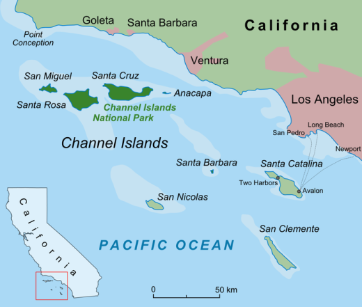
Channel Islands National Park

Channel Islands National Park consists of 5 of the 8 Channel Islands off the Santa Barbara coast. Although the islands are close to the shore, their isolation has left them relatively undeveloped.

The northern Channel Islands are Anacapa (1.1 sq mi), San Miguel (14.6 sq mi), Santa Cruz (96.5 sq mi) and Santa Rosa (83 sq mi) and the southern islands are San Clemente (57 sq mi), San Nicolas (23 sq mi), Santa Barbara (1 sq mi) and Santa Catalina (75 sq mi).

Channel Islands National Park includes the islands of San Miguel, Santa Rosa, Santa Cruz, Anacapa and Santa Barbara. Anacapa is located in Ventura County while the other four are in Santa Barbara County. San Clemente Island, the southernmost Channel Island, is owned and operated by the U.S. Navy. Catalina Island as we know with its population of 3,700 is a popular tourist destination. San Nicolas Island in Ventura County is also controlled by the U.S. Navy. On a clear day you can see two of the five islands, Anacapa and Santa Cruz.

ChannelIslandsMap.jpg

Visitors to the islands may swim, snorkel, hike, camp, watch wildlife, sail and explore tidepools, beaches and canyons. There is no food service on the islands, so bring what you need. Take a commercial service to the islands like Island Packers, which has been servicing the islands since 1968. Landings at Anacapa and Santa Cruz islands are year-round while the more remote outer islands, Santa Barbara, Santa Rosa and San Miguel are scheduled late spring through early fall.

Visit the National Park Service website at www.nps.gov/chis to learn more about visiting Channel Islands National Park. The park is open year-round.

The Robert J. Lagomarsino Visitor Center at Channel Islands National Park is located in the Ventura Harbor at 1901 Spinnaker Drive (805.658.5730) and the Outdoors Santa Barbara Visitor Center is located at the Santa Barbara Harbor at 113 Harbor Way, 4th Floor.

On a clear day you can see two of the Channel Islands from Newbury Park and other Ventura County spots. Here's a view from the Rancho Potrero Open Space in Newbury Park.

On a clear day you can see two of the Channel Islands from Newbury Park and other Ventura County spots. Here's a view from the Rancho Potrero Open Space in Newbury Park.

Anacapa Island seen from a whale watching boat.

Anacapa Island seen from a whale watching boat.

Old Boney Trail Hike in Pt. Mugu State Park

If you're looking for a hike of about 10 miles in the Rancho Sierra Vista/Boney Mountain Wilderness area, consider the Old Boney Trail loop from Newbury Park. You can park either in the National Park Service parking lot or at Wendy Drive where it meets Potrero Road.

You can do the hike clockwise or counter-clockwise since it is a loop course. I prefer clockwise, which starts by trekking through Rancho Sierra Vista to Danielson Road. Details of this path are at THIS LINK. This path gets you to a juncture where you can continue another 3/10ths of a mile to the Danielson Monument (which you definitely should do if you've never been there) or veer a sharp right up the Old Boney Trail.

Sign at juncture of Danielson Road trail and Old Boney Trail in Pt. Mugu State Park

Sign at juncture of Danielson Road trail and Old Boney Trail in Pt. Mugu State Park

I love the Old Boney Trail. It is narrow and covered with growth on both sides. Kind of like running through a chaparral jungle. This makes the trail mostly shade covered for the first couple miles of this 3.5 mile stretch of trail. You'll be treated to some nice views of Boney Mountain along the way.

OldBoneyTrail1.JPG

Although the Old Boney Trail does not reach a peak for panoramic views, you'll still find several spots that reward you with views towards the Channel Islands and west Ventura County.

OldBoneyTrail2.jpg

About a mile or mile and a half into Old Boney Trail from Danielson Road, you'll see a turnoff sign to the right that takes you to the Fossil Trail, a mile or so drop back down to the bottom of Sycamore Canyon. The drop is about 1300 ft to 500 ft with plenty of rocky surfaces, so you'll have some fun going back down this way, for a shorter route. And of course, look closely and you'll be treated to surfaces covered with sea fossil imprints from millions of years ago.

OldBoneyFossilTrailSign.JPG

From the Old Boney Trail/Fossil Trail juncture, you have another 2.1 fun miles to the next juncture at Blue Canyon Trail at the bottom of the canyon. You'll get some more neat views of Boney Mountain during this stretch. At the juncture is the following sign on Blue Canyon Trail.

Sign on Blue Canyon Trail at the Old Boney Trail juncture in Pt. Mugu State Park.

Sign on Blue Canyon Trail at the Old Boney Trail juncture in Pt. Mugu State Park.

You will turn right on Blue Canyon Trail, which will take you to the Danielson Multi-Use area and the paved Sycamore Canyon Fire Road. A left-hand turn will get you lots of fun for another day, onward to Chamberlain Trail that gets you up to some might nice peaks, and Serrano Valley.

Sign at entrance to Blue Canyon Trail at the Danielson Multi-Use area (you of course will be looking at the back side of this sign if you're coming from the Old Boney Trail).

Sign at entrance to Blue Canyon Trail at the Danielson Multi-Use area (you of course will be looking at the back side of this sign if you're coming from the Old Boney Trail).

I've never actually seen anyone using the Danielson Multi-Use area but here's the picnic area.

I've never actually seen anyone using the Danielson Multi-Use area but here's the picnic area.

So you run through the Danielson area to the main paved road to the right (turning left of course will take you to PCH in about 4-5 miles). In another 3 miles you'll be back in civilization; these miles include the 800 foot, 3/4 mile ascent into Rancho Sierra Vista, which can be a bit brutal...perhaps my (and maybe your) least favorite section of this course. But once you're up the hill, you're home free! Time for breakfast, lunch, dinner or all of the above!

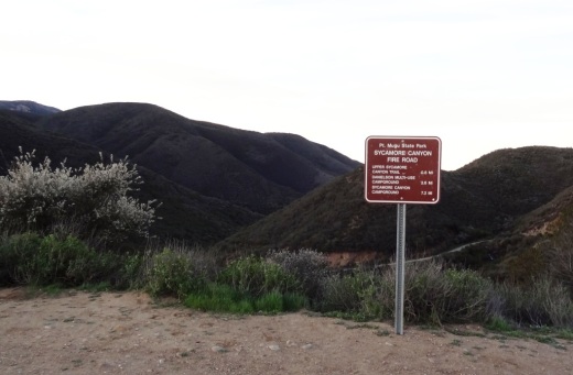
Sycamore Canyon Fire Road sign at the top of the hill in Rancho Sierra Vista/Satwiwa.

Sycamore Canyon Fire Road sign at the top of the hill in Rancho Sierra Vista/Satwiwa.

Of course, you can easily reverse this course and make your way DOWN Sycamore Canyon Fire Road, turn left onto Blue Canyon Trail, left on Old Boney Trail for 3.5 miles and then left on Danielson Road, back down into the canyon and up towards Satwiwa.