Voters Chose to Incorporate the City of Thousand Oaks Over the City of Conejo in a September 29, 1964 Special Election

City of Thousand Oaks Sign

On September 29, 1964, voters in the Conejo Valley were given the choice of whether to incorporate as a separate city in Ventura County and, if so, what to name this new city. It came down to 4,601 out of approximately 7,000 registered voters that Tuesday.

In March 1963, 27 local organizations gathered to form a Conejo City Committee to take steps to bring to a public vote the incorporation of the City of Conejo.

Conejo? Yes, Conejo. A 16 square mile city. There was plenty of controversy, since the name Thousand Oaks had been used for much of this area within the Conejo Valley for over 40 years.

A group of citizens successfully petitioned to add the name Thousand Oaks to the ballot as an alternative to Conejo..  A humorous example of some of the outrage over changing the name to Conejo is seen in this letter to the editor of the local Chronicle newspaper:

"Let's Not Drop Thousand Oaks" Conejo in Spanish means rabbit, and since talk has it to change our name to Conejo instead of our good old Thousand Oaks, I then suggest we cut down all our beautiful oak trees and replace each one with a nice fat rabbit so that we can identify ourselves with the strange new name which some newcomers have thrown at us without regard or consideration of our sentimentality and perhaps foolish tradition. If one lives in the San Fernando Valley in Canoga Park or Northridge, one says he lives in Canoga Park or Northridge in San Fernando Valley. So why can't we say we live in Thousand Oaks in the Conejo Valley or in Newbury Park in Conejo Valley. I don't care how we do it, just please let's not drop the name of Thousand Oaks." -Lucia Rios de Schneider, 3107 Radcliffe Road, Thousand Oaks

There were also a number of residents who did not want to be included in the incorporation initiative, including residents of Newbury Park, residents of the Rolling Hills area south of the 101, 500 acres of Janss Corporation owned land west of Cal Lutheran, 40 acres of land east and south of the Park Oaks Shopping Center and 100 acres of land south of the 101 owned by Louis Goebel.

Election Results - A City is Born

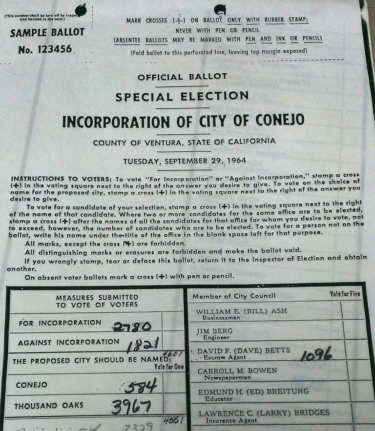
The Special Election for the Incorporation of the City of Conejo took place on Tuesday, September 29, 1964. Voting was a lot simpler back then. Instructions indicated to vote, "stamp a cross (+) in the voting square next to the right of the answer you desire to give." "On absent voter ballots mark a cross (+) with pen or pencil." The three measures submitted to vote were:

  • For or against incorporation

  • The proposed city should be named (vote for one): Conejo or Thousand Oaks

  • Vote for five city council members if the city is incorporated (there were 37 candidates on the ballot)

Portion of Sample Ballot from the September 29, 1964 Special Election for the Incorporation of City of Conejo (or Thousand Oaks, as the case were to be) (Courtesy Thousand Oaks Library Special Collections)

Portion of Sample Ballot from the September 29, 1964 Special Election for the Incorporation of City of Conejo (or Thousand Oaks, as the case were to be) (Courtesy Thousand Oaks Library Special Collections)

As you can see from the tallies written on the sample ballot above, residents voted to incorporate the city, but at 60% of the 4,601 votes it was not exactly a landslide. However, the desire to retain the name Thousand Oaks was quite clear, as 87% of votes tallied for this name over the city of Conejo.

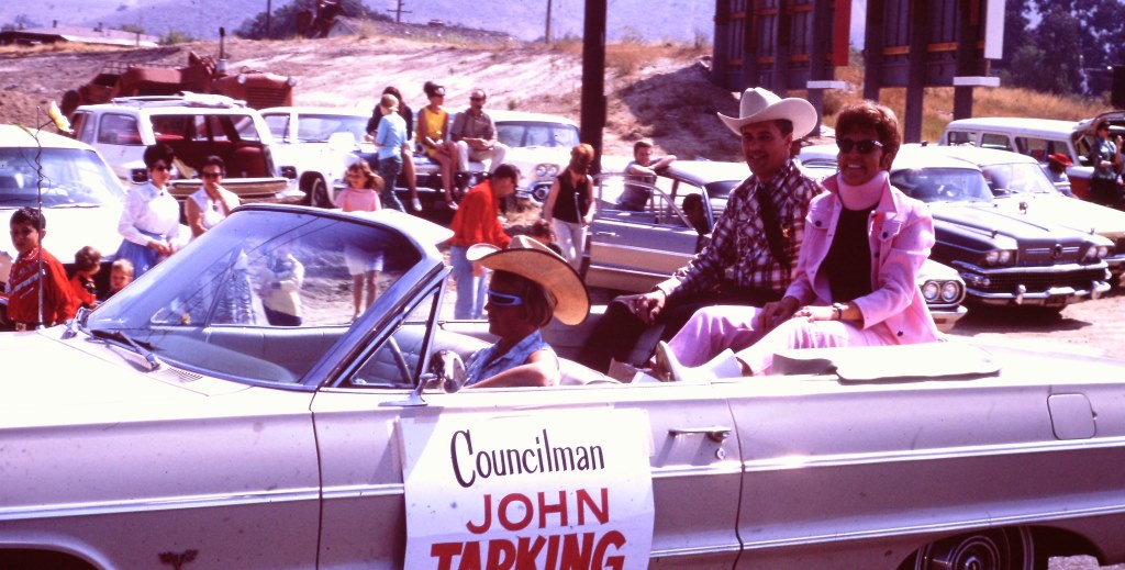
The first City of Thousand Oaks City Council consisted of pharmacist Robert Talley (2,598 votes), Ventura County planner John Tapking (1,574 votes), Accounting Chief Alexander Fiore (1,139 votes), escrow agent David Betts (1,096 votes) and engineer Lee Williams (1,056 votes).

Councilman and Thousand Oaks Mayor David Betts in the 1966 Conejo Valley Days parade.

Councilman and Thousand Oaks Mayor David Betts in the 1966 Conejo Valley Days parade.

Another one of the original city of thousand Oaks councilmembers, John Tapking.

Another one of the original city of thousand Oaks councilmembers, John Tapking.

The City of Thousand Oaks was officially incorporated on October 7, 1964. At the time, the population of the city was approximately 22,000. The U.S. Census estimates 2014 population at just over 129,000. The City turned 50 in 2014.

Where Did the Name "Thousand Oaks" Come From?

According to the late Pat Allen, historian for the city, mostly farmers lived in the Conejo Valley in 1922.  The 2,200 acre Crowley Ranch was sold and subdivided and lots were sold for $1,000. As lots sold and population grew, developers held a contest to name the new village. Sixteen year old Bobby Harrington entered the name "Thousand Oaks," he won the prize and the rest is history.

Thousand Oaks became a subdivision of Ventura County on May 1, 1923, as recorded by the County Recorder. The Thousand Oaks post office opened October 31, 1938 (compared to July 16, 1875 for the Newbury Park post office).

Sources: Thousand Oaks Library Special Collections and news articles from the Conejo News, The Chronicle and Oxnard Press Courier.

Cheeseboro Canyon vs Chesebro Road in Agoura Hills

CheeseboroApr18.jpg

Cheeseboro and Palo Comado Canyons cover over 4,000 acres in the northernmost section of the Santa Monica Mountains National Recreation Area, in the Simi Hills. The Chumash occupied these canyons for thousands of years, until ranchers came into the area in the 1800s. The natural landscape changed as a result to accommodate the needs of grazing cattle.

The National Park Service (NPS) acquired Cheeseboro Canyon in the early to mid 1980s and subsequently acquired Palo Comado Canyon (formerly known as the Jordan Ranch), in 1994.

Nearly every time we post an image from Cheeseboro Canyon to a social media site, someone points out, "it's not Cheeseboro, it's Chesebro."

Why is it called Cheeseboro when the road that gets you to the trailhead is called Chesebro?

According to one NPS Ranger I've spoken with, the original owner of the land in the late 1800s was Oscar Cheesebrough (yet a different spelling). The NPS adopted the U.S. Geological Survey spelling of Cheeseboro, while Caltrans adopted the name Chesebro.

Why the difference? That's not so clear. But what IS clear is that the actual canyon is called Cheeseboro Canyon and it is a beautiful place to hike and bike!

CheeseboroPic1.jpeg
ChesebroSign.jpg

Tell Me a Little Bit About Newbury Park

Newbury Park is a community located in the western portion of Thousand Oaks. Most of Newbury Park became part of Thousand Oaks by community vote sometime in the 1960s and 1970s. Thousand Oaks became a city in October 1964.

A view of Newbury Park from Boney Peak in October 2021. (Feet Model: Conejo Joe)

Egbert Starr Newbury (Photo Courtesy Conejo Valley Historical Society)

Egbert Starr Newbury (Photo Courtesy Conejo Valley Historical Society)

Newbury Park is named after Egbert Starr Newbury, who owned thousands of acres of land in the Conejo Valley after moving to California from Michigan for health reasons in 1871.  Newbury was one of the three largest Conejo Valley landowners of his time. He and his wife Fannie became the first postmasters in the Conejo Valley in 1875.  The post office was located in a small compound near their house, which was located at the current location of the Thousand Oaks Civic Arts Plaza

The other major landowners at that time were John Edwards, who owned much of the current Newbury Park/Thousand Oaks area north of the 101, and Howard Mills, who owned much of what today is Westlake Village and Hidden Valley.

Edwards sold 10,000 acres of what is now central Thousand Oaks to Edwin and Harold Janss in 1893.  The Janss Corporation also bought thousands of acres of land in Newbury Park (Friedrich, Running Springs and Borchard Ranches) in 1962. 

There were efforts to incorporate Newbury Park in 1961 and 1963 that failed due to a lack of sufficient votes.

Over a 30 month period beginning in the Fall of 1876, only 6 inches of rain fell in the Conejo Valley.  This drought brought devastation to landowners, most of whom lost their crops and livestock and had to sell at a loss or went bankrupt.  The Newburys were no exception; they moved back to the midwest in 1877.  Egbert fell ill to pneumonia in 1880 and passed away at the young age of 36.

The Newburys lived here only six years, so why is it still called Newbury Park? Because the name of the Newburys' post office never changed! The Newbury Park Post Office has changed locations a number of times (including 1602 Newbury Road from May 1968 until it moved to its current location at 3401 Grande Vista Drive in 2013). So the Newbury name and legacy live on here in the Conejo Valley.

Horse tied to a sign indicating the Newbury Park Post Office, in 1909. The location was near modern-day Lynn Ranch. (Courtesy of the Thousand Oaks Library Local History Photo Collection).

Horse tied to a sign indicating the Newbury Park Post Office, in 1909. The location was near modern-day Lynn Ranch. (Courtesy of the Thousand Oaks Library Local History Photo Collection).

Sources: "The Conejo Valley - Old and New Frontiers" by Carol A. Bidwell and "The Newburys of Newbury Park" by Miriam Sprankling

But wait...there's more to Newbury Park! Casa Conejo is also part of the Newbury Park community but is not an incorporated part of Thousand Oaks. It is considered a census-designated place in Ventura County, with its own Municipal Advisory Council. Casa Conejo is the first planned community in Newbury Park and was built in the early 1960s. It is has an area of .5 square mile and is bound by Borchard to the South, Old Conejo Road to the North, Jenny Drive (East of Newbury Park High School) to the West and Sequoia Middle School to the East.

TELL ME ABOUT THE HISTORY OF THE STREET NAMES IN THE CASA CONEJO NEIGHBORHOOD

Interested in historical pictures of the area going back to the 1950s?  Click here to read about the work of prolific Conejo Valley photographer, Ed Lawrence. 

Click here for a history of Thousand Oaks. Thousand Oaks is over 56 square miles and Newbury Park represents about 40% of that square footage. Thousand Oaks was incorporated as a city on October 7, 1964.

Three dozen or so things to do in Newbury Park

Another three dozen or so kids' activities in Newbury Park

Yet another three dozen or so sports and fitness activities in Newbury Park

The Carpinteria Tar Pits are One of Five Natural Asphalt Lake Areas in the World

The Carpinteria Tar Pits at Carpinteria State Beach are located in a designated area called Tar Pits Park. The Carpinteria Tar Pits are one of five natural asphalt lake areas in the world, 2nd in size to and older than the La Brea Tar Pits in Los Angeles.

These tar pits date back to the Pleistocene Age (Ice Epoch), which 2.6 million to 11,700 years ago. Evidence of imperial elephants, the giant sloth, bison, wolf, tusked mastodons and camels have been discovered in t

Read More

M*A*S*H Site at Malibu Creek State Park

Malibu Creek State Park is a wilderness wonderland, stretching over 8,000 acres in Calabasas, Agoura and Malibu. The park is a great place for hiking, biking, camping, picnicking and exploring. If you do plan to explore the park, be sure to check out the old M*A*S*H (or "MASH" television series set!

MalibuCreek_Mash1.jpg

Produced by 20th Century Fox, M*A*S*H was filmed from September 1972 to February 1983 over 11 seasons and 256 episodes on CBS. Exterior scenes were filmed at what is now Malibu Creek State Park. Over the years, the ambulance and other props left at the old site became less and less visible as the surrounding brush became overgrown.

In 2007, the set was restored with a shaded picnic area, military vehicles, ambulance, helipad and signpost. Check out the photos below, but, better yet, visit it in person! For more pictures and extensive information about the M*A*S*H set and Malibu Creek State Park, visit www.malibucreekstatepark.org.

MASH_sign.jpg

The M*A*S*H site is easily accessible from the main parking lot at Malibu Creek State Park, mostly on wide fire roads, with one significant hill, a bridge crossing and one somewhat rocky trail section. The path is about 2 1/2 miles each way, so it would be a good idea to bring drinks and snacks.

MalibuCreek_Mash2.JPG
MASH_3.JPG
MASH_4.JPG
MashSite4.JPG
MashSite6.JPG

Erbes Road in Thousand Oaks Named After Early Settlers in the Conejo Valley

Courtesy of Thousand Oaks Library calisphere.org/item/ark:/13030/c8w093ww

Courtesy of Thousand Oaks Library

calisphere.org/item/ark:/13030/c8w093ww

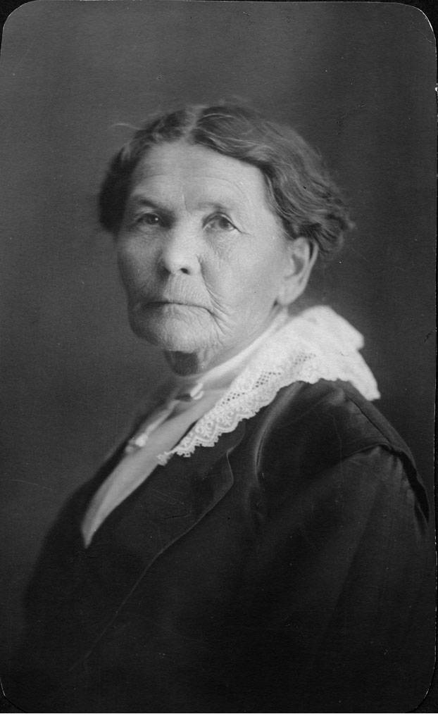
This is Elizabeth Opper Erbes. She is the mother of Ernest and Otto Erbes, who were early settlers in the Conejo Valley.

Otto (born in 1885, passed in 1959) owned a walnut orchard on what is now Erbes Road.

Estella Park on Erbes Road just south of Hillcrest is located on land donated to the city by Otto Erbes and his wife.

Erbes Road is a major north/south artery in the City of Thousand Oaks, stretching just over 5 miles, from Calle Zocolo, north of Olsen Road, on the north, to Thousand Oaks Boulevard on the south.

Olsen Road is also named after early Conejo Valley pioneer Nils Olsen. Olsen and four Norwegian compatriots purchased 650 acres of land from George Edwards in 1890.

The Twin Ponds Conservation Area in the Conejo Open Space is Protected Land

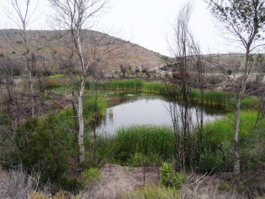
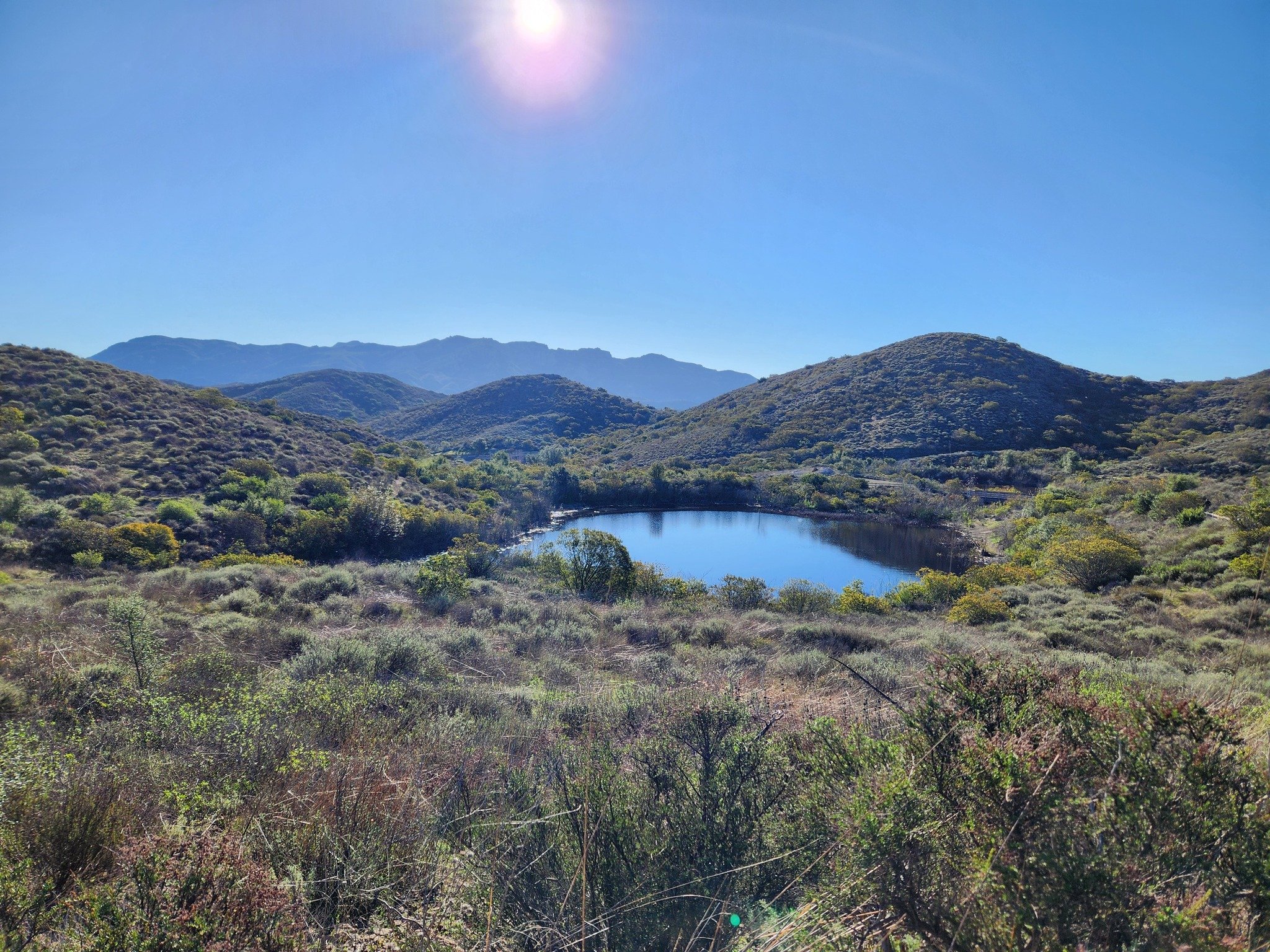
The Twin Ponds Conservation Area in Dos Vientos is part of the open space lands of the Conejo Open Space Conservation Agency and is protected by a conservation easement to the California Department of Fish and Game.

July 2014

July 2014

January 2015

January 2015

May 2016

May 2016

The ponds were originally constructed in the 1920s as part of the irrigation system for agricultural and cattle ranching operations at Dos Vientos Ranch. Today they serve as important habitat for Two Striped Garter Snakes and larger animals such as deer, bobcat, coyote and mountain lions that depend on a reliable source of water. Migrating waterfowl are occasionally abundant, especially in winter.

TwinPondsDV1.JPG

COSCA and Fish & Game ask that we enjoy this scenic area but protect the ponds for the future and ask that we do not enter the water or allow dogs/horses to enter the water, disturb or remove any animal or plant or place any plants or animals, including fish, into the ponds.

To explore the ponds, take the Vista Del Mar Trail from one of several access points in the Dos Vientos area, including the corner of Via Ricardo and Via Rincon and the corner of Rancho Dos Vientos and Via El Cerro. This is a fun little hike to take the kids on and the ponds are only about a mile from the Via Ricardo/Via Rincon trailhead.

Twin Ponds? What ponds? The ponds are completely dried up as of August/September 2016.

Twin Ponds? What ponds? The ponds are completely dried up as of August/September 2016.

January 2024

Late March 2024 - looking great!