Historical and Cultural Landmark Grandma Prisbrey's Bottle Village in Simi Valley

BottleVillage1.JPG

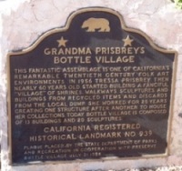
Grandma Prisbrey's Bottle Village in Simi Valley is a California Historical Landmark, Ventura County Cultural Landmark and is listed on the National Register of Historic Places.

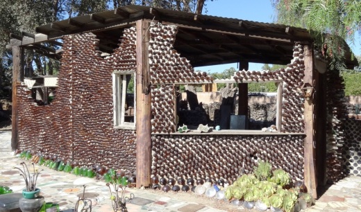
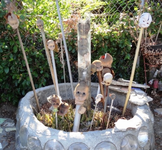
Bottle Village is a .3 acre lot located at 4595 Cochran Street that contains shrines, walkways, sculptures and buildings made from recycled items and discards from local landfills. All of these structures were built by hand over a 25 year old period by Tressa "Grandma" Prisbrey, beginning at age 60 in 1956 until 1972. Thirteen buildings and 22 sculptures in total.

BottleVillage8.JPG

A non-profit organization, Preserve Bottle Village (PBV), was formed in 1979. The 1994 Northridge Earthquake caused extensive damage to the Bottle Village site. PBV has embarked on a campaign to develop a master plan for the restoration of significant site components. Learn how you can help at bottlevillage.weebly.com. There’s also a more recent website, with link to social media and periodic tours, at www.bottlevillage.org.

Grandma Prisbrey sold the property in 1972 to care for an ailing son, but came back several years later to continue building and to give tours.  She died in 1988 at the age of 92.

BottleVillage9.JPG
BottleVillage11.JPG
BottleVillage7.JPG
BottleVillage5.JPG

Daylight Saving Time Ends on the First Sunday of November

iStock_fallback.jpg

Daylight Saving Time ends on the first Sunday of November each year in the U.S. (with the exception of Arizona and Hawaii). In 2024, that will be Sunday, November 3rd at 2 a.m.

At 1:59:59 a.m. on that Sunday, your clocks will revert back to 1 a.m. Yes! FALL BACK!! An extra hour of sleep!

The Energy Policy Act of 2005 gave us an extra month of DST by starting DST 3 weeks earlier and ending it one week later.

For my more precise readers, it is officially called Daylight Saving (not Savings) Time. So if you want to annoy your friends, correct them any time they call it Daylight SavingS time.

Also as one website I found mentioned, Daylight Saving Time is technically inaccurate, since we don't really gain daylight. It would more appropriately be called Daylight Shifting Time but I don't see that being a high priority initiative.

Before the adoption of standard time zones in the United States, cities, towns, and communities set their own local times based on the sun’s position. In 1883, railroad companies adopted a system of standard time to synchronize movement and trade across the nation. The U.S. adopted an official system of standard time in 1918.

The Standard Time Act of 1918 incorporated a DST mandate from the last Sunday in March to the last Sunday in October. Congress repealed the DST mandate in 1919. President Woodrow Wilson vetoed the repeal. Congress overrode his veto.

Beginning in 1920, DST was a local state/city option. Here’s the history of DST legislation in California:

1930: Prop 7 was but on the ballot to implement DST at 2 a.m. on the last Sunday in April until 2 a.m. on the last Sunday in September. The initiative failed.

1940: Prop 5 was put on the ballot to implement DST. The initiative failed again.

1949: Third time’s a charm. This time it passed.

1962: Prop 6 was passed, which extended DST from the last Sunday in September to the last Sunday in October.

2018: Californians voted in favor of Proposition 7 by a margin of 59.75% to 40.25%. Voting in favor of the proposition allowed the California State Legislature to change the DST period by a 2/3rds vote and to establish permanent, year-round DST in California by a 2/3rds vote if federal law is changed to allow for permanent DST.

Why the holdup?

The holdup is at the federal level, not the state level: Voting yes on Prop 7 was just the first step in the process. California is one of 14 states that introduced legislation in 2019 to shift to permanent daylight saving time. States cannot move forward with permanent daylight saving time without authorization from the federal government.

H.R. 1556 “Sunshine Protection Act of 2019,” was introduced to the House in 2018 and 2019 but failed. It was reintroduced in 2021 as SB 623 and H.R. 69 as the Sunshine Protection Act of 2021. The bill would make DST the new, permanent standard time. States with areas exempt from DST may choose the standard time for those areas. SB 623 was passed by the Senate but the House bill died in committee

The Sunshine Protection Act of 2023 (H.R. 1279, SB 582) was introduced March 1, 2023 but as of October 2024 has gone nowhere.

A Guide to Free Fun, Food and Festivities Around Ventura County

According to the Merriam-Webster Online Dictionary, the adjective "free" comes from the Old English "frēo," which is pretty much useless information to me. The more relevant definition to most of us is "not costing or charging anything." Now we're talking!

There are thousands of FREE things to do, see, eat and experience in the Conejo Valley, Ventura County and surrounding areas. Conejo Valley Guide is dedicated towards unearthing these FREE things year-round, from Kids Eat Free deals around town to annual events.

Here are some links to FREE (and nearly free) activities:

Free activities around Ventura County for all ages

Evolution of the Conejo Grade in Ventura County Over the Last 100 Years

Horseshoe shaped section of the Conejo Grade in the 1920s.

Horseshoe shaped section of the Conejo Grade in the 1920s.

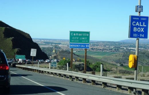
The Conejo Grade is the section of Highway 101 that connects the Conejo Valley with Camarillo. It is a four mile stretch of freeway with a significant 7% grade.

Going down the Conejo Grade from Newbury Park to Camarillo today.

Going down the Conejo Grade from Newbury Park to Camarillo today.

At 3:30 p.m. on the afternoon of May 1, 1937, a newly upgraded and realigned Conejo Grade premiered after a day of celebration commencing at the ranch of Adolfo Camarillo. Camarillo, the namesake of what in 1964 became the City of Camarillo, donated the right of way to enable the grade to be realigned. Actor Leo Carrillo entertained guests at Camarillo's ranch at the bottom of the grade.

Grand opening of the newly realigned Conejo Grade on May 1, 1937.

Grand opening of the newly realigned Conejo Grade on May 1, 1937.

The old Conejo Grade was constructed by the California Highway Commission in 1914-1915. The previous route had 49 twists and turns, making it somewhat hazardous to drive (albeit somewhat less steep than the current grade). The newly aligned Conejo Grade cut the number of curves by 75%.

Another view of the Conejo Grade before it was realigned in 1937.

Another view of the Conejo Grade before it was realigned in 1937.

The new 1937 Conejo Grade cost a total of $570,000, which is less than the average cost of a house in the Conejo Valley today! Over a year and a half, the project employed about 100 workers who put in over 272,000 hours, excavating over 800,000 cubic yards of mostly hard rock. Talk about rock stars!

In the 1950s and 1960s, Caltrans further widened and improved Highway 101 over the Conejo Grade.

In the 1950s and 1960s, Caltrans further widened and improved Highway 101 over the Conejo Grade.

Several decades later, as Ventura County grew and the cities of Camarillo and Thousand Oaks incorporated in 1964, Caltrans continued to widen and improve the highway to what it is today.

ConejoGrade2014_2.jpg

Source for historical information: "California Highways and Public Works" (May 1937) - official journal of the State of California Division of Highways, Department of Public Works.

Special thanks to the Pleasant Valley Historical Society for providing historic photos.

Tell Me a Little Bit About the City of Westlake Village Boundary

Westlake Village is a master-planned community that is transected diagonally by the Los Angeles/Ventura County line. 

The Ventura County side of Westlake Village, which is 8,544 acres, was annexed into the City of Thousand Oaks in 1968 and 1972. The Los Angeles County side of Westlake Village is 3,456 acres and was incorporated as the City of Westlake Village in 1981. 

Westlake Village Map.JPG

Ah yes, the challenge of distinguishing between the Los Angeles and Ventura County sections of Westlake Village. It truly is a diagonal boundary that stretches from just northeast of Lindero Canyon Road, south of Blackbird Avenue on the north to South Westlake Blvd at Kirsten Lee Drive on the south.

It is impossible to drive, bike or walk the boundary line because it crosses right through the middle of Westlake Lake. Although, you could drive along the border on La Venta Drive southwest from Watergate Road.

Further north, the border cuts diagonally across Westlake Golf Course.  In fact, the driving range section of the golf course bordered on the west by Lakeview Canyon Road and on the north by the 101 is located within the City of Thousand Oaks while the rest of the course is in Westlake Village.

Costco Westlake Village and the Four Seasons Westlake Village are solely part of the City of Westlake Village, as is the Las Virgenes Reservoir.

Does it really matter what side you're on? For most, no. But there's one clear financial difference. Sales taxes. As of July 2024, sales taxes in the Thousand Oaks/Ventura County portion of Westlake Village are 7.25% as compared to 9.5% in the Los Angeles County based City of Westlake Village. The difference is 2.25% for Los Angeles County district taxes. That means if you live in the City of Westlake Village, you’ll be paying $1,125 more for a $50,000 car than those living in the Ventura County portion of Westlake Village.

Las Virgenes Reservoir, the only body of water lying completely in the City of Westlake Village.

Las Virgenes Reservoir, the only body of water lying completely in the City of Westlake Village.

Areas in the Santa Monica Mountains Recreation Area Allowing Dogs on Leash

Pooch on leash

Pooch on leash

The Santa Monica Mountains National Recreation Area is the largest urban national park in the United States at over 150,000 acres, extending from the Hollywood Bowl on the east to Point Mugu at its western end; including the beaches of Santa Monica and Malibu as well as the canyons and peaks extending north to Simi Valley.

Dogs are allowed in a number of areas within the Santa Monica Mountains, as long as they are on leashes that are no more than 6 feet in length. Here is a listing of areas where dogs are allowed:

National Park Service: Arroyo Sequit (has been closed since the Woolsey Fire in 2018), Castro Crest, Cheeseboro/Palo Comado Canyons, Circle X Ranch, Deer Creek Canyon, Paramount Ranch, Peter Strauss Ranch, Rancho Sierra Vista/Satwiwa, Rocky Oaks, Solstice Canyon and Zuma/Trancas Canyons

Santa Monica Mountains Conservancy: Calabasas Peak, Dixie Canyon, Escondido Canyon, Franklin Canyon, Fryman Canyon, Marvin Braude Mulholland Gateway Park, Red Rock Canyon Park, San Vicente Mountain Park, Temescal Gateway Park, Wilacre Park

City of Malibu: Charmlee Wilderness Park, Malibu Bluffs

California State Parks: Pets are NOT allowed on backcountry trails of Topanga, Malibu Creek, Leo Carrillo and Point Mugu State Park, including the Boney Mountain Wilderness.

Canines are not allowed in the backcountry trails of Point Mugu State Park, including the Boney Mountain Wilderness.

Canines are not allowed in the backcountry trails of Point Mugu State Park, including the Boney Mountain Wilderness.

Dogs on leash are allowed at County Line Beach, Leo Carrillo State Park (on beach north of lifeguard tower 3 and campground only), Point Mugu State Park (on beach and campground only in Sycamore Cove and Thornhill Broome Beach), Will Rogers State Historic Park (day-use areas and loop road only)

L.A. City Recreation and Park District: Coldwater Canyon Park, Laurel Canyon Park, Runyon Canyon Park, Temescal Canyon Park

While you're out on the trails with your pooch, remember to pick up after your dog and bring plenty of water and food for you and Fido.

For more information, visit the Anthony C. Beilenson Interagency Visitor Center in Calabasas or www.nps.gov/samo.

Outside of the Santa Monica Mountains, trails in the Conejo Valley, Simi Hills and other local area locations are generally dog-friendly as long as your furry friend is on a leash. 

Dozens and dozens and dozens of local area trails and hikes

DOG PARKS IN AND AROUND VENTURA COUNTY

VISITING STATE PARKS WITH YOUR DOG

Bank of America "Museums on Us" Program Offers Free Admission to Over 225 Museums Nationwide

MuseumsOnUs.jpg

If you are a Bank of America or Merrill Lynch customer, your bank credit or debit card and photo ID will gain you one free admission to over 225 cultural institutions across the country on the first full weekend of each month. Visit the "Museums on Us" program website at museums.bankofamerica.com for details.

And while there are no Ventura County museums on the list, there are a number of other choices within driving range:

  • Autry National Center of the American West

  • Los Angeles County Museum of Art

  • Skirball Cultural Center

  • Museum of Latin American Art in Long Beach (Saturdays only)

  • Discovery Science Center, DiscoveryCube Orange County (Sundays only)

  • Santa Barbara Museum of Art

  • MOXI, The Wolf Museum of Exploration + Innovation in Santa Barbara

Free admission is limited to individual cardholder at participating institutions.