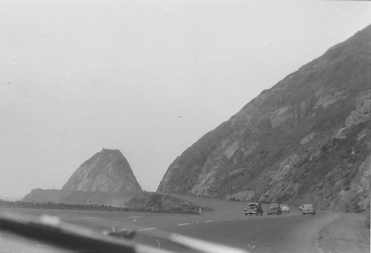
Northbound PCH Just South of Mugu Rock: 1950 and 2019

Mugu Rock came into existence in 1940 when a 200 foot cut was made into the mountain. Today it is an iconic scene that is often seen in auto commercials.

Taken on July 2, 1950, this is a view of Mugu Rock from the shoulder of northbound Pacific Coast Highway (SR 1). From a private collection. And below it is the same view, remarkably similar, 69 years later, on April 20, 2019. Thankfully, some things never change.

Mugu Rock 7.2.50.jpg
Mugu Rock 4.20.19.JPG

Lewis Road Pedestrian Overcrossing in Agoura Hills

This is the Lewis Road Pedestrian Overcrossing, Caltrans Bridge #53-998, in Agoura Hills. It connects Roadside Drive at Lewis Road on the south to Canwood Street at Lewis Road on the north side of the 101. It was built in 1963 and expanded in 1973.

This is the only pedestrian bridge going over a freeway in the Conejo Valley. There is another pedestrian bridge in Thousand Oaks - the Luedtke Bridge over Olsen Road that connects the CLU main campus to the northern campus.

Building Pacific Coast Highway Around Point Mugu in 1923-1924

Point Mugu before and after creation of a narrow road around it in 1924.

Point Mugu before and after creation of a narrow road around it in 1924.

According to the California Highway Commission in the October 1924 issue of “California Highways,” perhaps the most dangerous and difficult piece of construction work on the California state highway system at that time was the 3800 feet of grading AROUND Point Mugu.

For those driving Pacific Coast Highway in Ventura County past Mugu Rock, there are clear signs of this old route that took automobiles on a precarious route around Point Mugu.

Peaking through the fence towards the old road around Mugu Rock.

Peaking through the fence towards the old road around Mugu Rock.

The new and still existing route was created by blasting a massive hole through Point Mugu to create Mugu Rock in 1937 to 1940.

The work to complete this section of the Oxnard to San Juan Capistrano PCH route was authorized by a bond issue in 1919.

The project averaged 60 workers who moved 108,000 cubic yards or rock at a total cost of $108,500 (heck, that would be the cost of a pool addition and new kitchen remodel today). The cut around Point Mugu ranged from 40 feet on the ocean side to 115 feet on the high side in creating the narrow, short-lived roadway.

The California Highway Commission ended its article by stating “…along this piece of rugged coast line the Old Pacific is recognized as an arch enemy to whom we must trust as little as possible of our costly highway.”

Boy Scouts of America to Rebrand as Scouting America

The Boy Scouts of America today announced that it will rebrand to Scouting America, reflecting the organization’s ongoing commitment to welcome every youth and family in America to experience the benefits of Scouting. The change will go into effect on February 8, 2025, the organization’s 115th anniversary.

This announcement also comes as the organization celebrates the fifth anniversary of welcoming girls into Cub Scouting and Scouts BSA programs. Scouting America currently serves more than 176,000 girls and young women across all programs, including over 6,000 who have earned the rank of Eagle Scout.

Scouting America’s ongoing goal is to provide young people with a safe environment where they can learn meaningful life skills and have fun, educational experiences, fostering their growth and future outcomes as leaders, and be prepared for life. At the same time, values instilled by the Scout Oath and Law help prepare young people for lives of purpose and impact.

More than 130 million Americans have been through Scouting programs since its founding in 1910, and currently, more than 1 million youth, including both men and women, are served by 477,000 dedicated adult volunteers in local councils throughout the country. To date, more than 2.75 million youth have earned Scouting’s highest rank of Eagle Scout.

To learn more about Scouting America’s mission, visit Scouting.org

Mugu Rock at Point Mugu

Point Mugu is an unincorporated part of Ventura County that is derived from the Chumash word Muwu, or beach. Other than the Naval Base, probably the most well known fixture in Point Mugu is the Mugu Rock. Mugu Rock is a large rock formation that was formed when Pacific Coast Highway was built and cut through the mountain that now resides on the other side of PCH. Before PCH was built, a road went around the rock, where a chain link fence has been placed to keep people away from this hazardous area adjacent to the Pacific Ocean.  PCH was cut through Point Mugu from October 1937 to February 1940, according to this interesting KCET article.

MuguRock_pch.JPG

Mugu Rock is located just a few miles near the northwest tip of PCH before it veers north towards Oxnard. It is about a 10 mile drive from the Camarillo Premium Outlets and about 20 miles from the heart of Thousand Oaks taking either the 101/Lewis Road route or the slightly slower, curvy and interesting Potrero Road route.

Professional landscape and wildlife photographer Greg Clure of Newbury Park has shared a couple neat images facing Mugu Rock from the south. Visit Greg's website at www.gregclurephotography.com for more of his outstanding work.

ClureMuguRock2.jpg
ClureMuguRock1.jpg

And here is some not so professional video footage of Mugu Rock from the north.

Hal Watkins Scout Center and Scout Store at the C. J. Daily Ranch in Camarillo

Boy Scouts Daily Ranch lr.jpg

NOTE: On May 7, 2024, the Boy Scouts of America announced it will be rebranding as Scouting America on February 8, 2025.

The Hal Watkins Scout Center is located at the C. J. Daily Ranch, 509 East Daily Drive, Camarillo. The center is home to the Boy Scouts of America' Ventura County Council office. It also has a great Scout Store that stocks Scouting supplies and camping gear.

As of May 2023, the store is open 10 a.m. to 2 p.m. on Tuesdays (9 a.m. to 3 p.m. starting 6/3/2023) and 9 a.m. to 1 p.m. on Saturdays (10 a.m. to 2 p.m. and 4 p.m. to 7 p.m. starting 6/3/2023). Visit www.vccbsa.org/Scoutstore or call 805-482-8938 for more information.

The Ventura County Council serves more than 4,500 youth throughout the county and contributes thousands of service hours annually in community service through the annual Scouting For Food drive, Eagle Service Projects, and other unit, District, Council, and Order of the Arrow service projects.

Who is Hal Watkins? According to this L.A. Times article, Watkins was a longtime Ventura County resident and owner of several local car dealerships. He donated a 1906 house (see it HERE) to the Boy Scouts in 1973. He passed away in 1991 at age 66.

Scout Store is located in this building.

Scout Store is located in this building.

The History of Lake Sherwood

Lake Sherwood as seen from the Sandstone Peak trail in the Santa Monica Mountains.

Lake Sherwood as seen from the Sandstone Peak trail in the Santa Monica Mountains.

Lake Sherwood is an unincorporated community of about 1,500 residents in Ventura County overlooking the Lake Sherwood reservoir. It is south of Thousand Oaks and west of Westlake Village, off of Potrero Road,  accessible via Westlake Boulevard on the east and Wendy Drive and Reino Road in Newbury Park on the west.

For centuries, the Conejo Valley was inhabited by the Chumash. The Spanish came into the picture in the late 18th century and, when passing through what is now Hidden Valley, named the area the Potrero Valley.

The Potrero Valley was part of the original 48,761 acres constituting Rancho El Conejo. After California became the 31st state in 1850, a land commission was appointed to determine who owned land grants in the area.

Rancho El Conejo was sold in 1872 to John Edwards and Howard Mills. Mills received 22,240 acres that included the Potrero Valley in 1874. Mills sold the southeastern 8,476 acres to Joseph and Isabell McLaren Howard in 1875.

Photo of the Howard Ranch in the 1880s. The Howard residence was near where Triunfo Park is today in Westlake Village. (Courtesy of Conejo Through the Lens Collection; Thousand Oaks Library Special Collections.)

Photo of the Howard Ranch in the 1880s. The Howard residence was near where Triunfo Park is today in Westlake Village. (Courtesy of Conejo Through the Lens Collection; Thousand Oaks Library Special Collections.)

In 1888, the Howards sold the land to the Banning Company of Long Beach. In 1896, W. H. Matthiessen bought the Potrero Ranch from Banning. Then in 1904, Matthiessen built a 45 foot dam (originally called Alturas Dam) that created Potrero Lake (also referred to as Lake Matthiessen). Total capacity of the 156 acre lake, which today is called Lake Sherwood, is 877 million gallons of water.

In the early 1920s, the area around the lake was transformed into Sherwood Forest for the filming of Robin Hood, featuring Douglas Fairbanks. And of course that's where the name Lake Sherwood originated.

Meanwhile, W. H.'s son F. W. "Christy" Matthiessen married Elsie Mack in 1917. The couple made plans to develop the surrounding area as the Las Turas Lake Club in the 1920s. Except...they divorced in 1925, with Elsie receiving the portion of the ranch with the lake.

Elsie remarried. Her new husband's name was James Canterbury and briefly the lake became Lake Canterbury. After the stock market crash of 1929, the Canterburys sold the property to William Randolph Hearst. Hearst allowed the property to be used for filming of many films, including the 1938 The Adventures of Robin Hood.

In 1963, Dayton Realty purchased the lake and surrounding property. Dayton wanted to rezone the land to develop nearly 1,400 homes and commercial properties. This plan was fought off by local residents and rejected by the Ventura County Board of Supervisors.

From late 1983 to summer 1984, Dayton drained the lake, indicating that it needed to test the dam...which never happened...then never refilled the lake, leaving thousands of fish stranded and left to die in the mud. (Photo of draining of lake in January 1984)

Lake Sherwood was made available to the public after the depression of the 1930s until the lake was emptied in 1984.

A view of Lake Sherwood from the north off of Lake Sherwood Drive.

A view of Lake Sherwood from the north off of Lake Sherwood Drive.

In 1985, billionaire businessman David Murdock bought the dry Lake Sherwood lake bed and surrounding property.  His Ventura Farms and Lake Sherwood Ranch are on the old F. W. Matthiessen property in Hidden Valley.

In 1986, heavy rains filled Lake Sherwood back up, though it would take many years for the lake to regain the wildlife it lost after it was emptied.

Murdock developed the community with over 650 homes in three gated neighborhoods along with the Sherwood Country Club and Sherwood Lake Club. The lake is now privately owned and is not open to the general public.