Commemorative Air Force Aviation Museum at Camarillo Airport

Located at the Camarillo Airport at 455 Aviation Drive, the Southern California Wing of the Commemorative Air Force has hangars devoted to preserving, maintaining, displaying, and flying World War II aircraft.

The Commemorative Air Force Southern California Wing Aviation Museum is open Fridays and Saturdays from 10 am to 4 pm and Sundays noon to 4pm.

Donations requested of $15 for adults, $10 for ages 10 to 18, $5 for ages 6 to 10 and active military. Kids under 6 are free (as of January 2025). Visit www.cafsocal.com or call 805.482.0064 for more information.

Also, take a vintage WWII airplane ride on the only remaining U.S. Navy/Marine Mitchell B-25 PBJ Bomber, the open cockpit Primary Trainer PT-19, the SNJ Texan and the Aircoupe. Details at www.cafsocal.com/warbird-ride-program.

Docents are enjoyable to speak with as they have a lot of history to share at this museum. Two 15,000 sq ft hangars and a 32,800 sq. ft. hangar complex serve as a Museum Hangar and a Maintenance and Restoration Hangar.

The Museum Hangar contains some of the many artifacts that are currently on display as well as a gift shop. It also houses any of the aircraft that are not away on a mission or undergoing maintenance.  For safety reasons the maintenance hangar is not available for a walk-through, however visitors can observe any work in progress from behind a safety perimeter.

There are a number of aircraft on display, including several you can physically inspect, which is always fun to do with the kids. There are some interesting WWII exhibits on hand too. 

The only authentic Marine BPJ-1J variant of the famed Mitchell B-25 Bomber. It flew into Camarillo from Midland, TX in 1993 for a 20 year restoration project. It is now flight-ready!

The only authentic Marine BPJ-1J variant of the famed Mitchell B-25 Bomber. It flew into Camarillo from Midland, TX in 1993 for a 20 year restoration project. It is now flight-ready!

CAF_1.jpg
CAF_2.jpg
The Kakovlev Yak-3 is widely considered the lightest fighter aircraft between 1939 and 1945.

The Kakovlev Yak-3 is widely considered the lightest fighter aircraft between 1939 and 1945.

Conejo Creek Bike Path in Thousand Oaks

Conejo Creek Bike Path (Courtesy City of Thousand Oaks)

Conejo Creek Bike Path (Courtesy City of Thousand Oaks)

The Conejo Creek Bike Path is a 1.2 mile path in Thousand Oaks that connects Gainsborough Road on the south to Conejo Creek Park South. From there, you can cross Janss Road to get to the Thousand Oaks Library, Conejo Creek Park North, and the Thousand Oaks Teen Center

This path opened to the public in Spring 2011, providing a nice, flat alternative to city streets as it goes under State Route 23.

The paved path on Paige Lane ends at Janss Road across the street from the Thousand Oaks Library, but you can take the crosswalk at Janss Road at the crosswalk and from there get to a wide, fairly flat horse trail that takes you up to Avenida De Los Flores.

The east end of Gainsborough Road has an access point to the Conejo Creek Bike Path

The east end of Gainsborough Road has an access point to the Conejo Creek Bike Path

Nice flat path adjacent to city streets and neighborhoods

Nice flat path adjacent to city streets and neighborhoods

The path takes you under the 23 Freeway

The path takes you under the 23 Freeway

The path ends at Janss Road, across from the Thousand Oaks Library Conejo Creek Park North.

The path ends at Janss Road, across from the Thousand Oaks Library Conejo Creek Park North.

The City of Thousand Oaks maintains approximately 80 miles of bikeways, including about 3 miles of bike paths, roughly 54 miles of bike lanes and another 20 miles or so of bike routes.

Mt. McCoy Trail in Simi Valley

The Mt. McCoy Trail is located on the west side of Simi Valley with a trailhead at the corner of Washburn Street and Los Amigos Avenue (off the west end of Royal Avenue).

The trailhead at the corner of Washburn St and Los Amigos Avenue

The trailhead at the corner of Washburn St and Los Amigos Avenue

The Mt. McCoy trail is distinctive as there is a large white cross at the top of the mountain, which is about a 600 or so foot climb. From the trailhead, go straight and then take the switchbacks up the mountain.

At this first juncture, keep going straight (south) to the switchbacks. Turn right and you'll be going straight up the steep hill, like we did the first time.

At this first juncture, keep going straight (south) to the switchbacks. Turn right and you'll be going straight up the steep hill, like we did the first time.

Actually, after just a few hundred feet from the Washburn/Los Amigos trailhead, you'll reach a juncture where you either go straight (which is correct) or take a trail to the right, which is much steeper, but a much more direct path to the top. We made the mistake of taking that path the first time and it got us right up to the cross, but it is pretty steep.

The trails here are all really nicely groomed, thanks to the Rancho Simi Trailblazers and RSRPD. There are dozens of "shortcuts" along the trail but try to stick to the main path. Taking the correct path, with its switchbacks and twists and turns, is a bit over a mile to the top of Mt. McCoy, where you will be treated to panoramic views of the entire Simi Valley and the other direction towards the Reagan Library.  In fact, there are paths from the top that take you in other directions, including  a fire road that intersects with Presidential Drive to the Reagan Library.

View of the cross from about halfway up

View of the cross from about halfway up

A couple benches at the top of the hill to take in the beautiful views

A couple benches at the top of the hill to take in the beautiful views

McCoyTrail_cross2.JPG

The Rancho Simi Recreation and Park District owns 200 acres surrounding Mt. McCoy and the Rancho Simi Trailblazers helped construct the nicely maintained trail. Learn more at www.rsrpd.org/business_detail_T9_R17.php/

McCoyTrail_topview.JPG
Looking down from the cross to the south, where the benches and trailhead are.

Looking down from the cross to the south, where the benches and trailhead are.

Golf N' Stuff Ventura

For hours of amusement check out Golf N' Stuff off of Highway 101 in eastern Ventura. Golf N' Stuff features two 18-hole miniature golf courses, Indy style race cars (go-karts), bumper boats, bumper cars and a large arcade. You must be 4' 8" tall to drive the go-karts and at least 4' tall to drive the bumper boats and bumper cars.

Birthday parties at Golf N’ Stuff include pizza, cake, golf, rides, etc. The arcade is one of the largest around town.

Pricing (as of December 2024) is $18 per person for miniature golf (or $22 for 2 hours of unlimited play), $14 for go-kart rides, $12 for bumper boats and $12 for bumper cars (for the driver; $7 for passengers).

Golf N' Stuff is open 365 days a year. They usually open at 10am. Closing time varies by day from 8pm to 11pm. located at 5555 Walker Street, Ventura. Exit the 101 off Victoria, head North to Moon Drive, which turns into Walker, and turn left. The park is on the right hand side. More information at www.golfnstuff.com or call 805.644.7131.

GolfNStuffSign.jpg
GolfNStuffCtr.jpg
GolfNStuffCtr2.jpg
GolfNStuffC2H10.jpg

Camarillo Ranch House

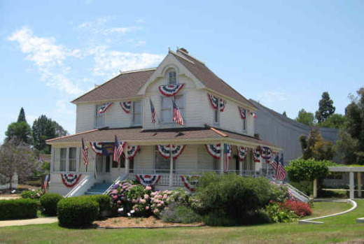
The Camarillo Ranch House is a 3-story, 14 room, 6,000 square foot Victorian home built by Adolfo Camarillo in 1892.  Adolfo is the son of Juan Camarillo, who purchased the land in 1866.  Adolfo operated the ranch from the time of Juan's death in 1880 until 1948.  Adolfo's name proliferates in Camarillo and the local high school was named after him after he gave 50 acres of land for that use.

The 4.5 acre ranch was given to the City of Camarillo by the Centex Company in 1997.  Today the property includes the house, a historic red barn and a stable.  In 2001, the City of Camarillo completed a $1.5 million restoration of the beautiful home to exhibit what it looked like during the 1914 to 1930 time frame. The Camarillo Ranch was added to the National Register of Historic Places in 2003.

The Camarillo Ranch is open to the public 7 days a week, 9am-5pm, unless there is holiday or special event. There is no charge to visit the property and walk the grounds during normal hours. The gardens have interpretive signs and there are also picnic benches available for use at lunchtime.

Docent-led tours of the house are currently (as of December 2024) offered on Saturdays and Sundays from 11 a.m. to 2 p.m. (last tour starts at 1:30 p.m.). House tour fees are $5 per person (cash only). Children 12 and under are free.

The property is used for many special events and can be reserved for private events like weddings and receptions.

The Camarillo Ranch House is located at 201 Camarillo Ranch Road.  Visit camarilloranchfoundation.com or call 805.389.8182 for more information.

CamRanchHousePic.JPG
Morton Bay Fig Tree

Morton Bay Fig Tree

Long Canyon Trail in Simi Valley

The Long Canyon Trail is an easy to hike trail in the Wood Ranch section of Simi Valley, located at the corner of Wood Ranch Parkway and Long Canyon Road (take Wood Ranch Parkway south until it ends, and turn right into the parking lot).

About a .7 mile hike to the top of the canyon connects you with the Lang Ranch / Woodridge Open Space in Thousand Oaks. Great views from the top towards Simi Valley,  Thousand Oaks and beyond, towards the Channel Islands on clear days.

More information at www.rsrpd.org/business_detail_T9_R16.php.

LongCanyon0.jpg
Technically I believe this bench is in the Lang Ranch/Woodridge Open Space in Thousand Oaks, which connects with the Long Canyon Trail. Nice view here towards Simi Valley.

Technically I believe this bench is in the Lang Ranch/Woodridge Open Space in Thousand Oaks, which connects with the Long Canyon Trail. Nice view here towards Simi Valley.

Lizard Rock Hike in Wildwood Park, Thousand Oaks

Lizard Rock is just over a mile from the main entrance to Wildwood Park at the west end of Avenida de los Arboles. Walk/run/hike the Mesa Trail towards Lizard Rock and you will be treated to beautiful views of the surrounding spaces where shows like Gunsmoke and The Rifleman were filmed.

The entrance area and dirt parking lot at the Wildwood Park main trailhead.

The entrance area and dirt parking lot at the Wildwood Park main trailhead.

LizardRockInDistance.JPG
Lizard Rock in the distance

Lizard Rock in the distance

View from on top of the lizard

View from on top of the lizard

Trail sign south of Lizard Rock indicating Lizard Rock Trail to Wildwood Canyon Trail

Trail sign south of Lizard Rock indicating Lizard Rock Trail to Wildwood Canyon Trail

You can make this hike a 4 1/2 mile loop past Paradise Falls and the Indian Creek Trail by reviewing the map on the Conejo Open Space Foundation website at cosf.org/trails/wildwood/wildwood-park-easy-hike-indian-creek.

Santa Rosa Loop Hike in Wildwood Park

The Santa Rosa Loop Hike at Wildwood Park in Thousand Oaks is a 6 1/2 mile trek with moderately challenging uphills and downhills. You’ll be rewarded with beautiful views of the Conejo Valley and Santa Rosa Valley.

Start at the main Wildwood trailhead at the west end of Avenida de Los Arboles. Take the main Mesa Trail towards Lizard Rock. You'll soon reach the Santa Rosa Trail sign, which points you north.

Box Canyon Loop Trail
As you crest the hill, follow the arrows toward the Lower Santa Rosa Trail.

As you crest the hill, follow the arrows toward the Lower Santa Rosa Trail.

Views of Santa Rosa Valley

So you're heading east and almost feeling like maybe you're getting lost, but this indeed is the Santa Rosa Trail. Just stay towards the left. It is single track much of the way over here. Then, you'll see the following sign as you get closer to the bottom of the Santa Rosa Valley.

So now you are zig zagging down the Shooting Star Trail, which eventually merges into the Lower Santa Rosa Trail.

(That said, you can continue east from the above juncture and make your way to Cal Lutheran.)

Now you're going to turn left (west) on Lower Santa Rosa Trail for some gentle slopes alongside private residences and farms in the Santa Rosa Valley for about a mile or so.

Some old farming equipment on the side of the Lower Santa Rosa Trail.

Some old farming equipment on the side of the Lower Santa Rosa Trail.

Then soon you come to the end of the trail and there's a sign that tells you to get back into Wildwood Park via the Box Canyon Trail, take the road up ahead 4/10ths of a mile. You're actually in Camarillo now on Rocky High Road.

The trail ends at the juncture of Talal Ct (private) and Rocky High Road.

The trail ends at the juncture of Talal Ct (private) and Rocky High Road.

At the end of the short stretch of road is the trailhead back into Wildwood Park.

And soon you'll see the Box Canyon Trail sign. Veer left (although I think if you go right it loops around to the main trail also).

Box Canyon Trail Sign

It's about a 300 foot climb over less than half a mile up the Box Canyon Trail that gets you back to the main Mesa Trail artery in Wildwood Park. Take your time...you're almost there!

Box Canyon Lizard Rock Sign Wildwood Park

Then you'll see the Lizard Rock / Box Canyon sign that signifies you are back at the Mesa Trail to head about half a mile back to the parking lot. Or turn right to check out the views from Lizard Rock before you go.

To see a map of this hike, visit www.cosf.org/website/html/santa-rosa-loop.html.

OK, so if you're looking to take a break and sit back and enjoy the view near the juncture of the Mesa Trail and Box Canyon Trail?  Then head back (west) from the "Lizard Rock/Box Canyon" trail sign above toward Box Canyon and take the trail on the left to the Box Canyon Overlook, where you will find the following place to park your rear end. Not a bad view, eh?

Bench at Box Canyon Overlook.

Bench at Box Canyon Overlook.

Sycamore Canyon Campground in Point Mugu State Park

Point Mugu State Park is located at 9000 W. Pacific Coast Highway, Malibu, offering a variety of beach, hiking and camping opportunities.

The Sycamore Canyon Campground is north of PCH, offering 58 tent/RV spaces along with drinking water, restrooms, showers and fire rings. There are also 4 tent spaces available for "Hike and Bike" campers. Pets are allowed on leash in the campground. Fees as of October 2024 are $35/night plus a $7.99 reservation fee at www.reservecalifornia.com (type in Point Mugu SP to find Sycamore Campground).

This campground is across the street from Sycamore Cove Beach, also part of Point Mugu State Park and just around the corner from the Thornhill Broome Campground on the beach, the giant sand dune across from Thornhill Broome, and Mugu Rock.

Sycamore Canyon has trails galore to explore, going all the way up, eight miles, to Newbury Park, if you so choose. Located just steps from the Sycamore Canyon Fire Road trailhead is the "Scenic Trail," a moderate trail with some steps that gets you to stunning views of everything mentioned above - beaches, Mugu Rock, sand dune, etc.

The Scenic Trail connects with the Overlook Fire Road, which continues on and eventually connects with the top of the Ray Miller Trail, then on towards the La Jolla Valley. It is lush and stunning when green in late winter/early spring. It gets pretty brown and dry up here towards last spring, summer and fall months. But the great views towards the Pacific never change.

California Oil Museum in Santa Paula

SUMMER 2022: THE CALIFORNIA OIL MUSEUM IS CURRENTLY CLOSED BUT IS MAKING SOME CHANGES. CHECK FOR UPDATES ON THEIR WEBSITE AT WWW.CAOILMUSEUM.ORG. (NO UPDATES AS OF DECEMBER 2024)

CalifOilMuseum_logo.jpg

The California Oil Museum at 1001 E. Main Street, Santa Paula (corner of Main and 10th) is the birthplace of Union Oil Company (aka Unocal and more recently acquired by Chevron in 2005).

The building was completed on October 17, 1890. at the Santa Paula Hardware Company Building, with the Union Oil Company offices upstairs. The company’s main headquarters moved to Los Angeles in 1900, but the building continued to serve as a field division office.

The Union Oil Museum was established in 1950. In 1990, the building was restored to its original appearance for its centennial celebration. Click here for an early picture of the building. The building is also a California Historical Landmark and is listed on the National Register of Historic Places.

The museum has one of the largest displays of vintage gas pumps in California. There is a turn of the century (20th century, that is) drilling rig, various displays, videos, working models and gas station memorabilia as well as rotating exhibits about science, technology and transportation as well as other local exhibits on hand.

As of spring 2022, admission was a suggested donation of $5 per person. Open Wednesday to Sunday, 10 am to 4 pm.

More information at www.caoilmuseum.org or 805.933.0076.

CalifOilMuseum.jpg
Left side of California Oil Museum on 10th Street

Left side of California Oil Museum on 10th Street

Display in the rig building.

Display in the rig building.

Gardens of the World - Thousand Oaks

Gardens of the World at 2001 Thousand Oaks Boulevard is a 4 1/2 acre garden across from the Civic Arts Plaza in Thousand Oaks.  It is free and open to the public Tuesday through Saturday from 9 a.m. to 5 p.m. (last admittance is 4:30 p.m.)  Closed Sunday and Monday and most national holidays. Gardens of the World is a gift from the Hogan Family Foundation.

GOTW_front2.JPG

Gardens of the World is an oasis of beauty in the middle of Thousand Oaks. There is a large bandstand in the center of the Gardens that is a perfect venue for outdoor music.  And the array of plants, flowers, waterfalls (including a stunning fountain that looks out toward the Civic Arts Plaza) and a serene koi pond next to an authentic Japanese Pagoda.

GOTW_WaterFountain.JPG

There is a Japanese garden, a French garden and waterfall (shown above), a Mission Courtyard, an English perennial and rose garden and an Italian garden.  A beautiful place to visit and relax for a bit, right in the heart of Thousand Oaks.  Also a great place for a picnic lunch, with plenty of tables, benches and grassy areas. More information at www.gardensoftheworld.info or 805.557.1135.

I never promised you a rose garden...but here's a beautiful one to check out!

I never promised you a rose garden...but here's a beautiful one to check out!

Koi pond in the Japanese Garden

Koi pond in the Japanese Garden

Shaded picnic area

Shaded picnic area

Since 2003, Gardens of the World has hosted a great Jazz Series on Sunday afternoons in August in this traditional American Bandstand area.

Since 2003, Gardens of the World has hosted a great Jazz Series on Sunday afternoons in August in this traditional American Bandstand area.

Lang Ranch/Woodridge Open Space Trails in Thousand Oaks

Looking for some spectacular trail hiking and panoramic views stretching from the Conejo Valley to the Simi Hills? Then take a look at the open space trails in the Lang Ranch/Woodridge system in the northeast portion of Thousand Oaks in the Lang Ranch area (where Avenida de los Arboles meets Westlake Boulevard).

The 1,025 acre area is maintained by the Conejo Open Space Conservation Agency (COSCA) and connects with another 8,000 acres of open space that is part of the Santa Monica Mountains. There are 10 miles of well-maintained trails that are outstanding for hiking, running and biking. The views are spectacular and you can actually hike from Thousand Oaks to Simi Valley (via the Long Canyon Trail) and Agoura Hills (Woodridge to Cheeseboro/Palo Comado).

More information about the various trails in the Lang Ranch/Woodridge Open Space on the Conejo Open Space Foundation website at cosf.org/trails/lang-ranch.

The specific trails seen below can be accessed from the Autumn Ridge trailhead at Westlake Boulevard and Autumn Ridge Drive in Thousand Oaks.

Access to this trail is at the corner of Westlake Bd and Autumn Ridge Dr

Access to this trail is at the corner of Westlake Bd and Autumn Ridge Dr

You can get a clear view of Bard Lake (Calleguas Water District Reservoir) from the Sunrise Trail, which parallels to the north of a portion of the Autumn Ridge Trail.

LangRanchTrail4.jpg
Checking out fossils on display in the open space. Pretty fun to see with the kids. The approximate spot of these fossil rocks is at THIS LINK.

Checking out fossils on display in the open space. Pretty fun to see with the kids. The approximate spot of these fossil rocks is at THIS LINK.

This bench is located at the juncture of the Sunrise and Meadow Vista Trails in the Lang Ranch Open Space and Long Canyon Trail, which is accessible via the Wood Ranch section of Simi Valley. Not a bad view, eh?

This bench is located at the juncture of the Sunrise and Meadow Vista Trails in the Lang Ranch Open Space and Long Canyon Trail, which is accessible via the Wood Ranch section of Simi Valley. Not a bad view, eh?

Trailhead at east end of Lang Ranch Parkway, to Albertson Fire Road trail.

Trailhead at east end of Lang Ranch Parkway, to Albertson Fire Road trail.

There’s another fun path I like to take in the Lang Ranch Open space. Take the Autumn Ridge Trail about half a mile and veer left at the Woodbridge Connector Trail, looping up and around to Wood Ranch in Simi Valley to the Long Canyon Trail trailhead, then back up to Lang Ranch. It’s only about 4 or 5 miles. See the map at cosf.org/files/maps/lang_ranch_trail_map.pdf for details.