Point Dume State Beach

On November 24, 1793, English explorer George Vancouver named the rocky promontory Point Dume after his friend, Father Francisco Dumetz. Point Dume is the western terminus of Santa Monica Bay and was named California Registered Historical Landmark No. 965.

PointDumeBeach.JPG

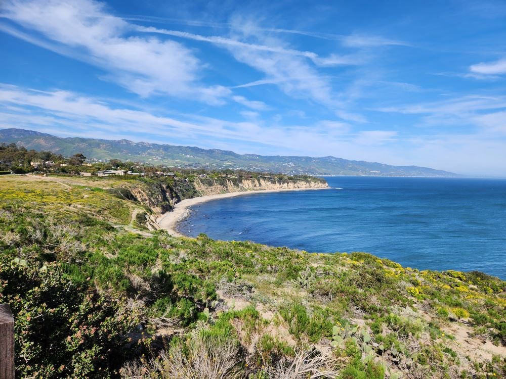
View in the spring of 2023

Point Dume State Beach is a 63 acre promontory that juts out into the Pacific and features headlands, cliffs, rocky coves and vast beach access for swimming, surfing and scuba diving.

To get to Point Dume State Beach, take Westward Beach Road southeast from PCH near Zuma Beach's south side to the paid parking area, or park on Westward Beach Road, which parallels Westward Beach.

To the southeast of Westward Beach is a small 300 foot or so beachfront area called Pirate's Cove Beach (which due to its seclusion was once used as a nude beach).

Pirate's Cove beach seen from the top of the promontory. You can climb down there and when the tide is moderate to low, walk around to it.

Pirate's Cove beach seen from the top of the promontory. You can climb down there and when the tide is moderate to low, walk around to it.

The 34-acre Point Dume Natural Preserve also begins from the cul-de-sac. A gradual ascending trail leads to an ancient coastal bluff sand dune with spectacular views...we've seen whales, seals and dolphins over here. A stairway from the east side of the bluff-top preserve allows access to a more isolated beach and tidepools (look but don't touch). You'll have fun exploring up here.

In the spring of 2023

This is a snippet of the pilot episode, "The Lady in the Bottle," of I Dream of Jeannie that originally aired September 18, 1965. If you skip to 1:39 in this clip, you will see the prominent rock formations on the east side of the Point Dume promontory. Below is a more recent shot of that area.

This is where Captain Anthony Nelson (Larry Hagman) made a giant S.O.S. in the sand with sticks and other items, including an old bottle that moved itself. He picks it up, dusts it off, and out pops Barbara Eden. Lucky guy!

This is where Captain Anthony Nelson (Larry Hagman) made a giant S.O.S. in the sand with sticks and other items, including an old bottle that moved itself. He picks it up, dusts it off, and out pops Barbara Eden. Lucky guy!

Location/Directions: Take Kanan south to PCH and turn right. Westward Beach Road is over the rise, at the foot of the hill. Park free on WBR or pay a fee at Westward Beach lot. No restrooms at the Preserve but some can be found on WBR. Call 310.457.8143 or visit www.parks.ca.gov/?page_id=623 for more information. Also see beaches.lacounty.gov/point-dume-beach.

Dogs are not allowed on trails in the Point Dume Natural Preserve or on the beach.

Westward Beach

Westward Beach

Springtime at the Point Dume Natural Preserve

Springtime at the Point Dume Natural Preserve

Surfer's Knoll Beach in Ventura

Surfer's Knoll Beach is located in Ventura adjacent from Ventura Harbor Village and as its name implies, is geared towards surfers, as well as others looking to relax and explore. Riptides are common here so be careful if you're a novice swimmer. There are restrooms and showers available. Lifeguard service on weekends only in May until Memorial Day weekend, then daily through Labor Day weekend. There is a relatively small parking lot available at 1596 Spinnaker Drive; parking is free.

One great thing about this beach is that it is one of the few almost completely westbound facing beaches throughout the area, meaning...it is a great place to catch the sunset! And several of the Channel Islands - Anacapa and Santa Cruz.

Though this is a nice, sandy beach, a better beach for kids/families is just north up the road at Harbor Cove Beach, which is calmer water, protected by jetties. 

Surfer’s Knoll Beach, Harbor Cove Beach and South Beach is managed by the Ventura Port District at venturaharbor.com/beaches.

Rincon Beach Park at the Ventura/Santa Barbara County Line

RinconPark.JPG

Rincon Beach Park is near the Ventura/Santa Barbara County line just a few miles east of Carpinteria. Just take the Bates Road offramp off the 101 Freeway (or type in Bates Road and Rincon Point Road, Carpinteria). Take Bates to the ocean and on the right you'll find plenty of free parking and easy beach access, with picnic tables and restrooms.

If you make a left turn off of Bates, there's a separate parking lot for Rincon Point, part of Carpinteria State Beach, one of the most popular surf destinations in the world. There are a couple of restrooms on this side also, albeit not particularly pleasant ones to use.

Campfires are not allowed on the beach.

To learn more about Rincon Beach Park or to reserve the picnic table, visit www.countyofsb.org/842/Rincon-Beach-Park or call 805.568.2465.

Views from the picnic area at Rincon Beach Park

Views from the picnic area at Rincon Beach Park

This sign always makes for great conversation starters at Rincon Beach Park

This sign always makes for great conversation starters at Rincon Beach Park

Westward Beach In Malibu

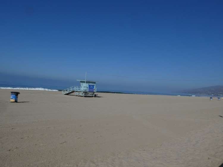
Westward Beach is about a mile strip of beach in Malibu, sandwiched between Zuma Beach and Zuma Lagoon on the northwest and Point Dume State Beach on the east.

This nice beach has both parallel street parking available on Westward Beach Road and a paid parking lot (which on a Sunday can cost $14; weekdays are less).

What I also like about Westward Beach is its close proximity to the Point Dume Natural Preserve, and the periodic sightings of seals, dolphins and other sea life.

Westward Beach generally is not as swim-friendly as nearby Zuma Beach as the waves are choppier and less duration and higher impact. While we've taken the boogie boards into the ocean here, we weren't particularly successful at catching waves here. That said...my little ones love playing in the sand and running from the waves here.

Another cool thing at the southwest end of the beach is a sheer cliff used for rock climbing.

There are restrooms available here as well as an outdoor shower facility.

Location/Directions: Take Kanan south to PCH and turn right. Westward Beach Road is over the rise, at the foot of the hill. Call 310.457.8143 or visit www.parks.ca.gov/?page_id=623 for more information.

Point Mugu State Park

Point Mugu State Park is located in the Santa Monica Mountains, stretching from Newbury Park on the north to five miles of ocean shoreline on the south. The park includes 14,000 acres of land with over 70 miles of trails popular with hikers, cyclists and runners.  It is truly an amazing place, with rocky peaks that include the prominent Boney Mountain State Wilderness that looks over the western Conejo Valley.

The sign in Rancho Sierra Vista/Satwiwa in Newbury Park indicating you are entering State-managed Point Mugu State Park.

The sign in Rancho Sierra Vista/Satwiwa in Newbury Park indicating you are entering State-managed Point Mugu State Park.

You can actually hike, run or bike from Newbury Park, from the Rancho Sierra Vista/Satwiwa area managed by the National Park Service down to the ocean via Sycamore Canyon "Sycamore to the Sea," which is about an 8 mile trip one way. But do be aware - the initial 800 foot drop from Rancho Sierra Vista into the canyon via Big Sycamore Canyon Road is a bit more challenging coming back up.

The paved hill drops into the canyon via Sycamore Canyon Fire Road.

The paved hill drops into the canyon via Sycamore Canyon Fire Road.

There are four main canyons in Point Mugu State Park. Sycamore Canyon is perhaps the most well known, stretching practically the entire north/south length of the park, where at the bottom of the canyon you'll find the 58 space Sycamore Canyon Campground at 9000 W. Pacific Coast Highway (make reservations at ReserveCalifornia.com and search for “Point Mugu SP”).

The Sycamore Canyon Campground connects to the Sycamore Canyon Fire Road, which is your access point to a day of fun and adventure in Point Mugu State Park trails.

The Sycamore Canyon Campground connects to the Sycamore Canyon Fire Road, which is your access point to a day of fun and adventure in Point Mugu State Park trails.

The La Jolla Valley Natural Preserve is on the western side of the park, with a main access point near Thornhill Broome State Beach at the Ray Miller Trailhead to the La Jolla Canyon Trail which connects with the Loop Trail. Another access point to La Jolla Valley is the Chumash Trail trailhead, a rocky, steep trail across from Point Mugu Beach. La Jolla Valley was purchased by the State of California in 1966 and was established as a Natural Preserve in 1972.
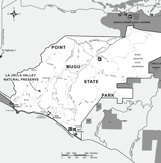
Wood Canyon is in the northwest section of the park, where you will find the north/south running Wood Canyon Fire Road, which connects to the Guadalasca Trail, among others.

Serrano Valley is accessible from the south off the Big Sycamore Canyon Fire Road/Trail about a mile north of the beach. A beautiful, serene, area, with a connection to the Old Boney Trail that takes you to the Danielson Monument in the Boney Mountain Wilderness.

The main beach areas in Point Mugu State Park, running southeast to northwest, are Sycamore Cove, Thornhill Broome and Point Mugu. Sycamore Cove is a fun day-use park popular with families for gatherings with BBQ grills and picnic tables. Learn more about beaches in the Malibu area at this link.

This is the PCH overpass where on low tide you can walk underneath here to get from Sycamore Cove Beach to Sycamore Canyon Campgrounds and hiking in Point Mugu State Park. In higher tides, this area can be dicey, so be careful.

This is the PCH overpass where on low tide you can walk underneath here to get from Sycamore Cove Beach to Sycamore Canyon Campgrounds and hiking in Point Mugu State Park. In higher tides, this area can be dicey, so be careful.

If you are looking for beachfront camping, try Thornhill Broome Beach, with just over 60 spots available for RVs and tents. No hookups here and only porta-johns available, but can't beat the views! And across the street you can't miss the Giant Sand Dune!

Day use parking at the various sites is available for $12. There is very minimal street parking at Sycamore Cove but plenty of street parking adjacent to Thornhill Broome Beach.

Dogs on a leash are allowed in the Park's day use areas, campgrounds and beaches. Dogs are not allowed on the back country trails or dirt roads.

Keep driving northwest on PCH and you'll past the famous Mugu Rock and see Pt. Mugu Beach, which also has day use parking, with some parking on PCH. Learn more at the California State Parks website at www.parks.ca.gov/?page_id=630.

Mugu Rock up ahead, driving north on PCH from Thornhill Broome.

Mugu Rock up ahead, driving north on PCH from Thornhill Broome.

Lastly, let's cover some of the highest peaks in Point Mugu State Park. The Boney Mountain Wilderness Area, ever so prominent from the Conejo Valley, is located in the Park. But Boney Peak itself, at 2828 feet, is actually in the Circle X Ranch area managed by the National Park Service, along with Sandstone Peak, the highest spot in the Santa Monica Mountains at 3111 feet.

Boney Mountain range overlooks the western Conejo Valley.

Boney Mountain range overlooks the western Conejo Valley.

Other peaks include Tri Peaks at 3010 feet, Laguna Peak (the peak which has equipment from Naval Base Ventura County below), La Jolla Peak and Mugu Peak

Map of Point Mugu State Park courtesy of National Park Service.

Map of Point Mugu State Park courtesy of National Park Service.

Rincon Point in Carpinteria

RinconPoint_sign.JPG

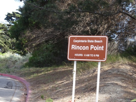
Rincon Point is home to one of the most popular surfing spots in the world. Accessible near the Ventura/Santa Barbara County line just a few miles east of Downtown Carpinteria. Take the Bates Avenue offramp off the 101 Freeway towards the ocean. On the right is access to the City of Carpinteria's Rincon Beach Park and on the left is access to the Rincon Point parking area. Open 6am to 9pm daily, with a not-particulary-nice porta-john available in the parking area.

There is a trail that takes you to the beach area from the parking lot. The area is also surrounded by beach homes.

A view toward the north from Rincon Point (in the direction of Rincon Beach Park).

A view toward the north from Rincon Point (in the direction of Rincon Beach Park).

THE BEACH BOYS INCLUDED A REFERENCE TO RINCON IN SURFIN' SAFARI:

At Huntington and Malibu

They're shooting the pier

At Rincon they're walking the nose

We're going on safari to the islands this year

So if you're coming get ready to go

Zuma Beach in Malibu

zuma sign.JPG

Zuma Beach is located at 30000 Pacific Coast Highway At 4 miles long, Zuma is one of the largest and most popular beaches in Los Angeles County,

Zuma is known for its long, wide sands and excellent surf. Plenty of facilities, including several food stands, restrooms, showers, volleyball, etc. Plenty of street parking on PCH and over 2,000 parking spaces (currently $8 weekdays and $10 weekends).

Visit beaches.lacounty.gov/zuma-beach for more information. Zuma is known for riptides, so do be careful out there.

zuma beach.JPG

Soter Point at Marina Park in Ventura

SoterPoint1.JPG

Dedicated in 2011, Soter Point at Marina Park in Ventura consists of a shaded picnic area, benches, attractive landscaping and a 15 foot mermaid statue. Soter Point is the result of a private/public partnership between local Ventura residents and the City of Ventura.

The inscription on a plaque on the Mermaid of Soter Point tells the story:

This stunning landmark overlooking the Ventura Harbor represents a trailblazing cooperative effort to beautify our community through private citizens working with public agencies. Andy Soter developed and landscaped the area in memory of his daughter Andrea, a successful and much admired investment manager. The mermaid sculpture and its foundation were donated by Russian emigrants Alec and Tatyana Benke, as an expression of love for their new country, America. Samuel Povar created the first collaboration of this nature in 2007 as a tribute to his late wife Orianna and worked tirelessly to make this Marina Park project a reality. And, the Ventura City Council and the Coastal Commission gave their enthusiastic blessing. Now Povar, Soter, and Benke, all Ventura residents, hope to inspire others to use private capital along with public cooperation and support…to envision something beautiful and make it happen.

Soter Point is located at the southernmost point of Marina Park, a short walk from the main playground area of the park. With beautiful views looking out toward Ventura Harbor and picnic area cooled by sea breezes, Soter Point does not Disa-Point.

Bench faces south toward Ventura Harbor Village

Bench faces south toward Ventura Harbor Village

SoterPoint3.JPG
SoterPoint4.JPG
SoterPoint6.JPG

Gondola Paradiso at Channel Islands Harbor

GondolaParadiso.jpg

Founded in January 2014, Gondola Paradiso provides luxury Venetian-style cruises through the canals of the Channel Islands Harbor in Oxnard.

Cruises leave from Seabridge Marina, located off South Victoria Avenue at the Channel Islands Harbor, 1301 S. Victoria Avenue, Oxnard. To book a cruise, call (805) 612-4475 and for more information visit www.gondolaparadiso.com.

gondolo1.jpg

San Buenaventura State Beach in Ventura

San Buenaventura State Beach is a two-mile stretch of beach from the Ventura Pier on the north down south past the homes of the Ventura Keys to just north of Marina Park on the south.

This beach features swimming, surfing and picnicking. There are two miles of sandy beach, sand dunes, picnic sites, a parking lot, restrooms and the Jolly Oyster. San Buenaventura State Beach features the largest day-use picnic area at a state beach in Southern California.

Looking to ride a bike but didn’t bring one? Rent one near the pier at Wheel Fun Rentals.

There’s a nice mile-long hike and bike trail along the beach stretching from the park entrance at San Pedro Street and Pierpoint Blvd to the Ventura Pier. This trail continues northward up the boardwalk past Surfers’ Point and beyond. CLICK HERE for more details on the Omer Rains Trail.

The 1,700-foot pier has a snack bar, Beach House Fish restaurant and bait shop. Wheel Fun Rentals is right near the pier if you need a bike. Visit www.parks.ca.gov/?page_id=600 or call 805.585.1850. Campfires not allowed at this beach.

Plenty of parking available for a fee, accessible at San Pedro Street and Pierpont Boulevard in Ventura, as well as additional parking with direct access to the Ventura Pier at 1156 E. Harbor Boulevard.

Malibu Lagoon Field Trips Hosted by Santa Monica Bay Audubon Society

The Santa Monica Bay Audubon Society (SMBAS) hosts Malibu Lagoon Field Trips the 4th Sunday of every month.

Adult Walk starts at 8:30 a.m. for 2-3 hrs. The group meets at the metal-shaded viewing area next to parking lot. SMBAS makes a special effort to make these monthly Malibu Lagoon walks attractive to first-time and beginner birdwatchers. Brings binoculars and cameras.

Metal shaded viewing area next to parking lot.

Metal shaded viewing area next to parking lot.

Children & Parents Walk starts at 10:00 a.m. for a 1 hr session. Meet at metal-shaded viewing area next to parking lot. SMBAS leaders are experienced with kids so by all means bring them down to the beach to enjoy nature. Binoculars will be provided.

Upcoming dates: 9/27/20. (SUBJECT TO CHANGE DUE TO COVID - PRIOR MONTHS HAVE BEEN CANCELLED)

If you have a Scout troop or other group 7 or larger, please call Lu at 310.395.6235 to make sure SMBAS has enough binoculars and docents on hand.

Visit smbasblog.com to learn more.

Directions: Malibu Lagoon is located at the intersection of Pacific Coast Highway and Cross Creek Road in Malibu. Bring water and sun protection; look around for people wearing binoculars and hats.

Parking: Self-serve parking machine in lot, $3/hr, $12 day ($11 seniors); credit cards accepted. Annual passes accepted. You may also park (read all signs carefully) on PCH west of Cross Creek Road, on Cross Creek Road, or on Civic Center.Way north (inland) of the shopping center. Lagoon parking in shopping center lots is not permitted.

Channel Islands Sportfishing Center

Ciscos.jpg

Channel Islands Sportfishing Center (aka Cisco's) is located at the Channel Islands Harbor at 4151 S. Victoria Avenue, Oxnard. Cisco’s has a fleet of 11 boats (as of February 2020) and operates 7 days a week.

Enjoy 1/2 day, 3/4 day, full day, overnight and two day trips. The Speed Twin is a nice foray into sportfishing for newbies - a half day trip on a boat with a capacity of 75 people. it departs at 8 am and returns at 4pm. You can bring your own fishing rods or rent them for $15 at the landing. You’ll also need a one day fishing license that you can buy there.

Visit www.channelislandssportfishing.com or call 805.382.1612 to learn more and to book your next fishing trip.

CiscosSpeedTwinCV.jpg

El Pescador Beach in Malibu

El Pescador Beach ("The Fisherman") has the distinction of being the closest beach in terms of auto mileage from central Thousand Oaks, located at 32900 Pacific Coast Highway, just east of the intersection of Decker Canyon Road and PCH. Along with La Piedra Beach and El Matador Beach, El Pescador is part of the Robert H. Meyer Memorial State Beach. 

El Pescador Beach is located about 2 1/2 miles east of Leo Carrillo State Beach and 5 miles west of Zuma Beach. Along with the other two beaches, El Pescador has a parking area (for a fee) and a porta-john. Dogs are not allowed on state beaches. There is also limited parking on PCH available, but be sure to look at the signs to make sure you don't park in a "no parking" zone.

Steep, uneven stairs lead you to the beach. Not particularly stroller friendly as a result, but it's not that far to go. This beach never seems to be crowded, which is a good thing.

You can explore trek over to La Piedra Beach from here, at least when the tide is not too high.

Bottom half of the steps from the parking lot to El Pescador Beach.

Bottom half of the steps from the parking lot to El Pescador Beach.