Seven Flat, Stroller and Family Friendly Hikes in the Conejo Valley

There is a ring of about 15,000 acres of open space with 140 miles of trails for public use surrounding the Conejo Valley. All too often on the Conejo Valley Guide Facebook Page we hear requests for which trails are "stroller friendly" and/or suitable for young children. Here is a sampling of some of the more popular ones in the area.

Wildwood Park to many is the single greatest spot for family hikes and stroller-friendly trails. With 14 trails covering 17 miles, including the popular hike to Paradise Falls and the teepee as well as some wide, relatively flat sections along the Mesa Trail towards Lizard Rock.

It takes a bit of driving via the Norwegian Grade and Santa Rosa Road to get there, but the Conejo Canyons Open Space in the Western Plateau section of the Conejo Open Space leads to several miles of nice, flat, well-maintained family-friendly trails leading to tree-canopied picnic areas. The Hill Canyon Trail and Hawk Canyon Trail are very easy to navigate.

Shaded picnic area off the Hawk Canyon Trail from the Conejo Canyons Bridge.

Shaded picnic area off the Hawk Canyon Trail from the Conejo Canyons Bridge.

The one mile Spring Canyon Trail is a mostly flat trail that runs from Lynn Oaks Park, 359 Capitan Street, Newbury Park to the Los Robles Trail.  There are some moderate hills but with the park nearby, this makes for a fun little excursion with the little ones. (No restrooms, however.)

The main access point to the Los Robles Trail at the southern endpoint of Moorpark Road at Greenmeadow Ave starts out with a reasonably flat section that is a nice, easy family stroll.

Speaking of the Los Robles Trail, another great little hike to take with the kids is the Oak Creek Canyon Loop Trail. The first 4/10th of a mile of the trail, accessible off of Greenmeadow Avenue in Thousand Oaks, is the Oak Creek Canyon Whole Access Interpretive Trail. This is a nice, shady, flat trail with benches and picnic benches along the path. The remainder of the loop is not quite as stroller friendly, with a couple moderately steep sections that can be navigated on foot.

Picnic trails and shade abound at the Oak Creek Canyon Interpretative Trail.

Picnic trails and shade abound at the Oak Creek Canyon Interpretative Trail.

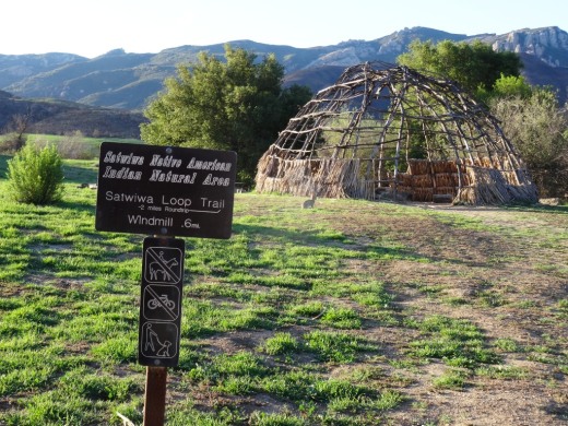
The Rancho Sierra Vista/Satwiwa area managed by the National Park Service in Newbury Park has several miles of trails to explore, most of which are flat and stroller-friendly. The Satwiwa Loop Trail takes you around the area and the Satwiwa Native American Indian Culture Center makes for a fun stop with the family when open on weekends.

The Chumash home, or “‘Ap,” in the background. The one pictured has since been replaced.

The Chumash home, or “‘Ap,” in the background. The one pictured has since been replaced.

Cheeseboro/Palo Comado Canyons offer great family hiking opportunities. While there's definitely hills surrounding these canyons, try the Cheeseboro Canyon Trail, the 4 to 5 mile main artery into the park. Flat and kid/stroller friendly it is. Also try the Doubletree Trailhead connector to the Palo Comado Trail. Flat, fun and scenic.

The Los Padres Trail in Thousand Oaks is a short trail, half of which is pretty flat and tree lined, if you’re looking for a short excursion with a toddler. A seasonal creek makes it even more interesting as you may hear froggies in the spring.

PaloComadoSign.JPG

Although the trails in the Lang Ranch/Woodridge Open Space in Thousand Oaks are NOT FLAT and indeed quite HILLY, they are worth checking out with the kids because they wide and have some interesting sandstone rock formations. If you are really strong, strollers are possible here, but do know that you will encounter some hills like the hill shown in the image below.

This hill in the Lang Ranch/Woodridge Open Space at the Autumn Ridge Trail is a bit daunting but worth the climb.

This hill in the Lang Ranch/Woodridge Open Space at the Autumn Ridge Trail is a bit daunting but worth the climb.

We're going to throw a bonus trail into the mix. The several miles of hiking trails in the Oakbrook Regional Park Archaeological Area in Thousand Oaks is an outstanding place for a flat, picturesque and oak-tree canopied place for a short hike with the kids.

For a more comprehensive compilation of trails in the Conejo Valley and throughout Ventura County, visit THIS LINK.

Erbes Road in Thousand Oaks Named After Early Settlers in the Conejo Valley

Courtesy of Thousand Oaks Library calisphere.org/item/ark:/13030/c8w093ww

Courtesy of Thousand Oaks Library

calisphere.org/item/ark:/13030/c8w093ww

This is Elizabeth Opper Erbes. She is the mother of Ernest and Otto Erbes, who were early settlers in the Conejo Valley.

Otto (born in 1885, passed in 1959) owned a walnut orchard on what is now Erbes Road.

Estella Park on Erbes Road just south of Hillcrest is located on land donated to the city by Otto Erbes and his wife.

Erbes Road is a major north/south artery in the City of Thousand Oaks, stretching just over 5 miles, from Calle Zocolo, north of Olsen Road, on the north, to Thousand Oaks Boulevard on the south.

Olsen Road is also named after early Conejo Valley pioneer Nils Olsen. Olsen and four Norwegian compatriots purchased 650 acres of land from George Edwards in 1890.

Tennis Courts Open to the Public In and Around Ventura County

Looking to play a little tennis in and around Ventura County? There are over 150 tennis courts open to the public throughout the county. Here they are compiled into one list. 

Contact us with any additions!

Thousand Oaks/Newbury Park

Agoura/Oak Park/Calabasas

TennisCourt.JPG

Camarillo

Oxnard

  • Carty Park, 3900 South F Street - 1 court

  • College Estates Park, 1400 Gary Drive - 1 court

  • Community Center West Park, 801 Hobson Way - 8 lighted courts

  • East Park, 351 Indus Place - 1 court

  • Fremont Tot Park, 1130 North M Street - 2 courts

  • Lemonwood Park, 2055 East San Mateo Place - 2 courts

  • Marina West, 1300 South Novato Drive - 2 courts

  • Orchard Park, 2130 Edelweiss Street - 1 court

  • Peninsula Park, 3333 South Peninsula Road - 2 courts

  • Rio del Mar Elementary, 3150 Thames River Drive - 1 court

  • Rio Lindo Park, 841 Blanca Street - 1 court

  • Sea Air Park, 2011 Ninth Street - 2 courts

  • Seabridge Park, 3900 LMD, W. Wooley - 2 courts

  • Via Marina Park, 3301 Keel Way - 1 court

  • Wilson Park, 350 North C Street - 1 court

Ventura

www.cityofventura.ca.gov/1774/Tennis-Pickleball

Simi Valley

Moorpark

Ojai

Port Hueneme

  • Moranda Park, 200 Moranda Parkway - 8 courts

Tennis courts at Borchard Park in Newbury Park are nicely maintained.

Tennis courts at Borchard Park in Newbury Park are nicely maintained.

Stay Cool in the Pool! Community Swimming Throughout Ventura County

Stay cool this summer and year-round at some of these community swimming pools, water parks and splash pads in Ventura County and surrounding areas. For updates and additions, contact us!

Conejo Valley (Conejo Recreation & Park District)

CLU_pool.jpg

Community Pool at Cal Lutheran University Samuelson Aquatics Center is a year-round facility, offering recreational and lap swimming 7 days a week. Call 805.241.0894 or visit www.crpd.org. General admission is $4 ($3 for 62+ with ID). Water is heated up to 82 degrees year round.  www.crpd.org/aquatics.

Newbury Park High School Community Swimming Pool is at 456 Reino Road. Open during the summer only. Entry fee $4 per person. Call 805.498.6906 or visit www.crpd.org/facilities/community-pools.

Thousand Oaks High School Community Swimming Pool is at 2323 N. Moorpark Road is open during the summer only. Call 805.496.8564 or visit www.crpd.org/facilities/community-pools.

Conejo Valley/Agoura - Other

Children’s Splash Pad/Water Area at Oak Canyon Community Park, 5600 Hollytree Drive, Oak Park. Hours of operation are 10am to 7pm. 2024 Splash Pad season opens Saturday, May 25 and ends on Monday, September 2. Free of charge. 818.865.9304

Kids love the Interactive Fountain at Janss Marketplace.

Moorpark/Simi Valley

Rancho Simi Recreation and Park District offers a large community swimming pool at Rancho Simi Community Park, 1765 Royal Avenue. Pool hours at www.rsrpd.org/recreation/aquatics.php but open rec hours are 1-3pm M-F 6/10 to 8/14 and 1-4pm Sat/Sun 6/8 to 9/8 . Admission $4 for ages 2 to 49 and $2 ages 50+.

Rancho Tapo Splash Pad

Rancho Tapo Splash Pad

Childrens' Splash Pad Area at Rancho Tapo Community Park, 3700 Avenida Simi. Free. Opens Saturday, May 25, 2024 and closes on Monday, September 2nd. Hours are 11am to 2pm and 3-7pm daily. www.rsrpd.org/business_detail_T9_R45.php

Simi Valley Aquatics is available for swim lessons and birthday parties only.

Simi Valley Family YMCA heated indoor swimming pool open 7 days/week.

Camarillo/Oxnard

Pleasant Valley Aquatic Center offers an indoor swimming pool with eight swimming lanes, a one meter diving board, 65 foot spiral water slide and more. Pool heated between 81 and 83 degrees. Open Tues/Thur/Fri/Sat for recreational swim from 1:30-4pm 6/17 to 8/23. $4 for ages 4+, free to ages 3 and under and $3 ages 60+. Visit www.pvrpd.org/aquatics or call 805.987.8198. 

Camarillo Family YMCA swimming pool open Mon-Sat. Call 805.484.0423 or visit www.ciymca.org/locations/camarillo-family-ymca

There's a "Pop Jet Fountain" at The Collection at Riverpark in Oxnard, on Town Center Drive in front of the Lazy Dog Restaurant & Bar and adjacent to Larsen's Grill.

Ventura and Up the Coast

Ventura Aquatic Center has a 25 meter recreational pool, 50 meter competition pool, playground pool, two slides, and more! Open swim free for age 2 and under, $10 for ages 3 and up. Visit www.cityofventura.ca.gov/612/Aquatics or call 805.654.7511 for details. BEST TO RESERVE A SPOT IN ADVANCE AS CAPACITY IS LIMITED. Open swim schedule for summer 2024 (June 17-Aug 9) is 1-4:30pm Mon-Fri and 12:30-4pm Sat/Sun.

Casitas Water Adventure is open all summer on select days - the Lazy River, Mega Play Unit Structure with 2 water buckets and 5 slides (2 for children; 3 for teens/adults), Splash Pad and Lagoon. 2024 season runs from May 25 to August 13 (weekdays); September 14 (for weekends). Weekend morning sessions 10:30 am to 2 pm and afternoon sessions 3 to 6:30 pm. Weekday hours are 11am to 6pm.

Call 805.649.2233 or visit www.casitaswater.org/casitas-water-adventure to learn more and reserve a spot. Cost is $20 per person on weekdays and $23 for weekends. Free entry for under two years of age.

Ventura Family YMCA has 2 indoor heated swimming pools and is open 7 days/week.

Carpinteria Community Pool is located at 5305 Carpinteria Avenue. Day passes are $5 for 12 and under, $7.00 for ages 13-64, $5 for seniors. Recreational swimming on weekdays varies; Saturdays from 11am to 3pm. Visit carpinteriaca.gov/parks-and-recreation/carpinteria-community-pool for more information.

The Leo Robbins Community Sailing Center at Marina Park in Ventura is a U.S. Sailing Association certified facility for lessons in sailing, kayaking and navigation for all ages.

Other Places Around Town

The Calabasas Tennis & Swim Center located at 23400 Park Sorrento is open 7 days/week. $7 for adults, $4 for seniors $1 for kids under 13. (3 and under are free). Pool hours vary. Visit www.cityofcalabasas.com/government/community-services-parks-recreation/tennis-swim-center or call 818.222.2782. Pools heated to 82 degrees year-round.

The Splash Pad at De Anza Park at 3701 Lost Hills Road, Calabasas is usually open during the summer Mon-Fri 11am to 5pm

Malibu Community Pool at Malibu High School, 30215 Morning View Drive. Outdoor pool heated to 82 degrees. $3 per person. Visit www.malibucity.org/Facilities/Facility/Details/Malibu-Community-Pool-7 or call 310.589.1933 for details.

The Fillmore Aquatics Center at 575 1st Street opens Memorial Day through Labor Day each year for recreational swimming Monday through Friday from 11:30am-3:45pm and Saturdays 10am to 4pm. More information and fees at www.fillmoreca.com/176/Parks-Recreation or 805.524.4902. 

And let's not forget the incredible BEACHES close by! CLICK HERE for links to over 40 public beaches throughout Ventura County, stretching north to Carpinteria and south to Malibu.

Water Parks Outside of Ventura County

Knott's Soak City in Buena Park (about 70 miles from Thousand Oaks)

Legoland California Water Park in Carlsbad (135 miles from Thousand Oaks)

Raging Waters Water Park in San Dimas (75 miles from Thousand Oaks)

Six Flags Hurricane Harbor in Valencia (50 miles from Thousand Oaks)

Hansen Dam Aquatic Center in Lakeview Terrace with a large pool, cabanas and two water slides. 

Hiking and Exploring in Rancho Sierra Vista/Satwiwa in Newbury Park

Entrance to Rancho Sierra VistaSatwiwa at Lynn Road and Via Goleta in Newbury Park

Located on the western edge of the Santa Monica Mountains National Recreation Area, Rancho Sierra Vista/Satwiwa is accessible in Newbury Park at the intersection of Lynn Road and Via Goleta. This area spans from Potrero Road on the north and connects to Point Mugu State Park on the south.

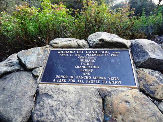
Ranching in the area dates back to the early 1800s, when Spanish soldiers were granted 48,672 acres of land, "Rancho El Conejo," which through the years was subdivided and sold to other landowners. One of these ranchers was Carl Beal, who in 1937 named the area Rancho Sierra Vista "Mountain View Ranch." The last private landowner in the area was Richard Danielson, whose family farmed and ranched the area for 32 years. Danielson donated 5,585 acres of the ranch to the State of California, which became part of Point Mugu State Park, and sold 850 acres, including the horse ranch, to the National Park Service in 1980.

Sign at Danielson Monument accessible via Danielson Road/Old Boney Trail.

Sign at Danielson Monument accessible via Danielson Road/Old Boney Trail.

The Satwiwa Native American Indian Natural Area is a bike/horse free area within Rancho Sierra Vista/Satwiwa of roughly 60 acres. Located on the northwest corner of this area, just a short walk from visitor parking, is the Satwiwa Native American Culture Center.

The Culture Center is staffed from 9 a.m. to 4 p.m. most weekends with a park ranger or other staff. It is a small building that also hosts a variety of educational Chumash and wildlife items. NPS BROCHURE AND TRAIL MAP

Learn more about RSV at www.nps.gov/samo/planyourvisit/rsvsatwiwa.htm.

SatwiwaSign.JPG

The area is a popular destination for hikers with a variety of well maintained trails. Note, however, that bicycles and horses are not allowed in the "Satwiwa Natural Area" section (see map below).

Map excerpt courtesy of National Park Service.

Map excerpt courtesy of National Park Service.

The Satwiwa Loop Trail is an easy, 2 mile trail that starts at the Culture Center through grasslands, past the old windmill and back around, with several extensions for those looking to do a little more.

SatwiwaLoopTrail_sign.jpg

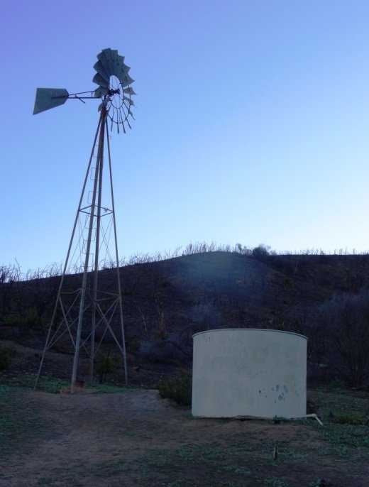
There's the Lower Loop Trail and the Upper Loop Trail that is a bit of a zig-zaggy trail with wooden footings placed by volunteers to help hikers navigate. The Upper Loop Trail runs past the "Old Windmill" pictured below.

Satwiwa Lower Loop sign at intersection of Danielson Road trail.

Satwiwa Lower Loop sign at intersection of Danielson Road trail.

The old windmill at the northeast corner of the Satwiwa Loop Trail (Upper Loop). (Windmill was knocked down by high winds in December 2016 and is still down as of MAY 2024).

You can also park at the Wendy and Potrero trailhead and walk to the Culture Center via the Wendy Trail, about a mile each way.

Wendy Trail trailhead at the intersection of Wendy and Potrero in Newbury Park

Wendy Trail trailhead at the intersection of Wendy and Potrero in Newbury Park

It is pretty dry in here most of the year but after the winter/spring rains, the green stages a comeback.

It is pretty dry in here most of the year but after the winter/spring rains, the green stages a comeback.

Another trail to explore is the 1 mile Ranch Overlook Trail that takes you from just west of the Satwiwa Native American Indian Culture Center, up a hill (where you can indeed look down toward the old ranch area, parking area and restrooms) to the main entrance and to the Palomino Trail in the Rancho Potrero Open Space.

Ranch Overlook Trail

Ranch Overlook Trail

One of my favorite trails in Rancho Sierra Vista/Satwiwa is the Hidden Valley Overlook Trail. This challenging, fairly steep trail branches off from the Satwiwa Loop Trail on the southeast, past the bench at the Upper Sycamore Canyon Overlook, via the Boney Mountain Trail/Danielson Road.

The popular bench at Upper Sycamore Canyon Overlook. Photo taken April 4, 2014, approximately 11 months after the devasting Springs Fire of 2013.

The popular bench at Upper Sycamore Canyon Overlook. Photo taken April 4, 2014, approximately 11 months after the devasting Springs Fire of 2013.

Roughly 700 feet past the Upper Sycamore Canyon bench is a juncture where you can either veer right into Point Mugu State Park and the Boney Mountain Wilderness, where you can walk down, over a stream (or a dry stream bed as the case may be), towards the popular "waterfall" (which in recent years has been not much more than a trickle) and the Danielson Monument. CLICK HERE for details.

If you veer left at the juncture, you'll see the Hidden Valley Overlook trail sign.

HiddenValleyOverlook_sign.jpg

The trail is steep and rocky and reaches an end point in about half a mile. If you are up to the challenge, you will be rewarded with sweeping views of Newbury Park, the Channel Islands, Sycamore Canyon and Boney Mountain.

Views from halfway up the Hidden Valley Overlook Trail towards the Satwiwa Native American Indian Natural Area

Views from halfway up the Hidden Valley Overlook Trail towards the Satwiwa Native American Indian Natural Area

At the end of the trail is the Hidden Valley overlook, where you will be able to peek into the not-so-hidden-anymore Hidden Valley and its peaceful ranches. As a final reward for your effort, it's all downhill the way back. Be sure to wear solid hiking shoes as the trails are a bit technical.

Peek at Hidden Valley at the end of the Hidden Valley Overlook Trail.

Peek at Hidden Valley at the end of the Hidden Valley Overlook Trail.

View of Santa Cruz Island, one of the Channel Islands, from Hidden Valley Overlook trail

View of Santa Cruz Island, one of the Channel Islands, from Hidden Valley Overlook trail

To learn more, visit the Anthony C. Beilenson Visitor Center at 26876 Mulholland Highway, Calabasas or visit www.nps.gov/samo or call 805.370.2301.

Dogs are allowed in Rancho Sierra Vista/Satwiwa as long as they are on a leash no longer than 6 feet. But please, pick up after your pet. Dogs are not allowed in the Point Mugu State Park / Boney Mountain Wilderness back country trails, though they are allowed on paved roads, such as the Big Sycamore Canyon Trail road.

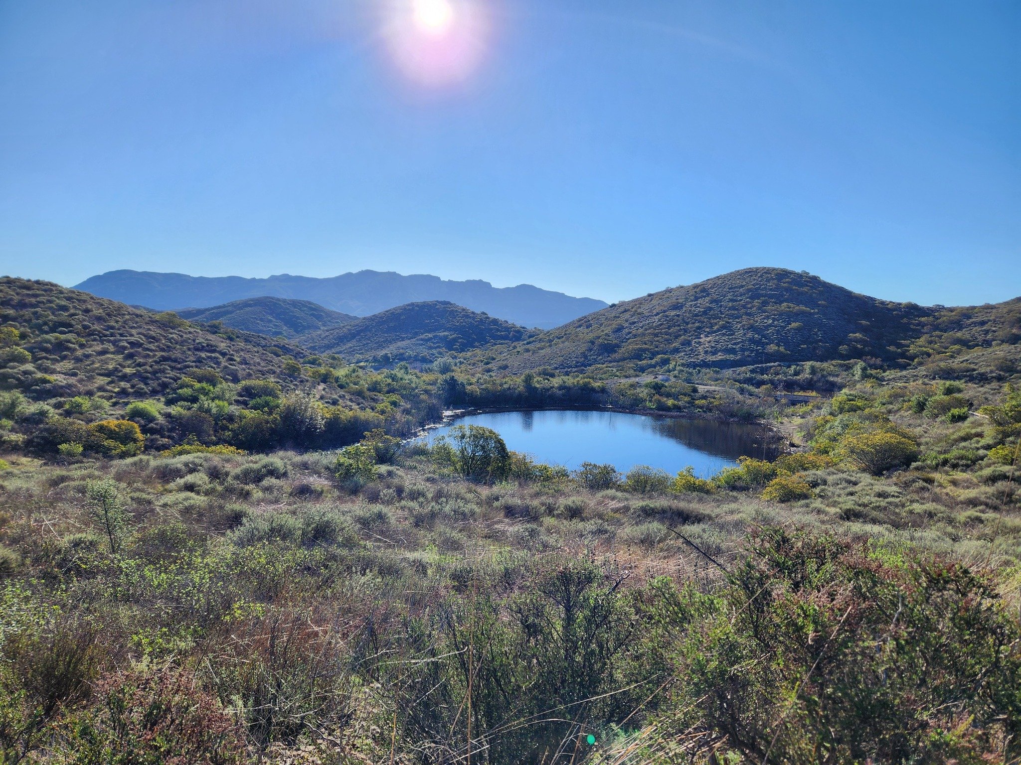
The Twin Ponds Conservation Area in the Conejo Open Space is Protected Land

The Twin Ponds Conservation Area in Dos Vientos is part of the open space lands of the Conejo Open Space Conservation Agency and is protected by a conservation easement to the California Department of Fish and Game.

July 2014

July 2014

January 2015

January 2015

May 2016

May 2016

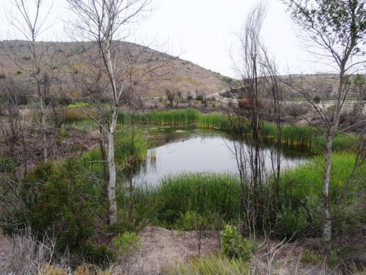
The ponds were originally constructed in the 1920s as part of the irrigation system for agricultural and cattle ranching operations at Dos Vientos Ranch. Today they serve as important habitat for Two Striped Garter Snakes and larger animals such as deer, bobcat, coyote and mountain lions that depend on a reliable source of water. Migrating waterfowl are occasionally abundant, especially in winter.

TwinPondsDV1.JPG

COSCA and Fish & Game ask that we enjoy this scenic area but protect the ponds for the future and ask that we do not enter the water or allow dogs/horses to enter the water, disturb or remove any animal or plant or place any plants or animals, including fish, into the ponds.

To explore the ponds, take the Vista Del Mar Trail from one of several access points in the Dos Vientos area, including the corner of Via Ricardo and Via Rincon and the corner of Rancho Dos Vientos and Via El Cerro. This is a fun little hike to take the kids on and the ponds are only about a mile from the Via Ricardo/Via Rincon trailhead.

Twin Ponds? What ponds? The ponds are completely dried up as of August/September 2016.

Twin Ponds? What ponds? The ponds are completely dried up as of August/September 2016.

January 2024

Late March 2024 - looking great!

Map From Westlake Master-Planned Community Brochure from 1968

In 1968, the American-Hawaiian Land Company, a division of American-Hawaiian Steamship Company, was developing the Westlake master-planned community, "the new city in the country."

At the time, 2,500 people lived in Westlake. The Ventura County sections of Westlake were annexed into the City of Thousand Oaks in 1968 and 1972. The Los Angeles County section of Westlake was incorporated as the City of Westlake Village in 1981. Some notable items from this 1968 map from a Westlake brochure:

1. "El Conejo Blvd." was later changed to Thousand Oaks Blvd.

2. Westlake Plaza did not exist at the time, though you can see "Future Town Center."

3. What is now Westlake Village Inn, Mediterraneo and Stonehaus back then was the Westlake Motor Hotel, Westlake Inn restaurant and Chauncey's Coffee House.

4. Last, but not least, there was no Costco in the original planned community map.

More information about the City of Westlake Village boundary lines at THIS LINK.