The Pedestrian Tunnel Under Avenida De Los Arboles in Thousand Oaks

There's a pedestrian tunnel that connects the Wildflower Playfield on Avenida De Los Arboles at Canna Street that goes underneath Arboles to Wildwood Neighborhood Park.

At the west end of Wildwood Neighborhood Park is a trail that will take you into Wildwood Park, and from there, you can either loop around back to the main Wildwood Park trailhead at the west end of Arboles, or turn back the way you came.

Wildwood Neighborhood Park was home to the original Wildwood Fort, built in 1967, but torn down in 2009 due to deterioration. New playground equipment was installed in 2021. There is also a playground across the street at Wildflower Playfield, along with restrooms at both parks. More info at www.crpd.org.

Playground at Wildwood Neighborhood Park

Concert Venues in Ventura County and Adjacent Venues

Looking to attend a concert in the Conejo Valley, greater Ventura County and adjacent areas? Here’s a compilation of such concert venues. For a separate listing of local area restaurant and bars where you can catch live music, visit THIS LINK.

The Bank of America Performing Arts Center (BAPAC) Thousand Oaks is one of the largest performing arts centers between Los Angeles and San Francisco at over 200,000 square feet. Managed by the City of Thousand Oaks, the BAPAC encompasses two theatres – the 1,800-seat Fred Kavli Theatre and the 394-seat Janet and Ray Scherr Forum Theatre. Located at 2100 E. Thousand Oaks Boulevardbapacthousandoaks.com

The Santa Barbara Bowl, located at 1122 N. Milpas Street, Santa Barbara, was originally built in 1936 and today with its capacity of nearly 5,000 people is the largest outdoor amphitheater in Santa Barbara County. www.sbbowl.com

The Majestic Ventura Theatre offers a 1920's Mission Style Architecture ambiance - you can see and feel close to the band from practically anywhere in the theater. All genres of music. 1200 capacity venue with multiple full bars, ballroom and occasional dinner shows. The theater is located at 26 S. Chestnut Ave., Venturawww.venturatheater.net 

Ventura Music Hall is located at 1888 E. Thompson Blvd in Ventura, hosting live music and offering craft food and drinks. www.venturamusichall.com

The Simi Valley Cultural Arts Center is a 220 seat theater at 3050 Los Angeles Avenue that hosts musicals, concerts, exhibits, children's theater and other events year-round.  The theater is a landmark Gothic structure built in the 1920s that was named as Ventura County Historical Landmark #67 in July 1981.  The building has served numerous purposes since inception and became the Cultural Arts Center in November 1995.  www.simi-arts.org

The Oceanview Pavilion located at 575 E. Surfside Drive in Port Hueneme offers concerts, theater, fairs, shows and a variety of other events for all ages.  The venue has a capacity for up to 1400 people and can be rented out for special events. www.oceanviewinfo.com

The Oxnard Performing Arts & Convention Center at 800 Hobson Way has over 1,600 seats in a theater that showcases local theater, dance, music and other programs. www.theopac.org

The High Street Arts Center at 45 E. High Street has been owned by the city of Moorpark since 2005, the theater now provides high quality theatrical performances and concerts at reasonable prices  www.highstreetarts.com

The Lisa Smith Wengler Center for the Arts at Pepperdine University, located on campus at 24255 Pacific Coast Highway, Malibu, showcases musicians, performers and artists from around the world at its Raitt Recital Hall (100 seats), Smothers Theatre (500 seats), Helen E. Lindhurst Theatre and the Frederick R. Weisman Museum of Art. www.arts.pepperdine.edu

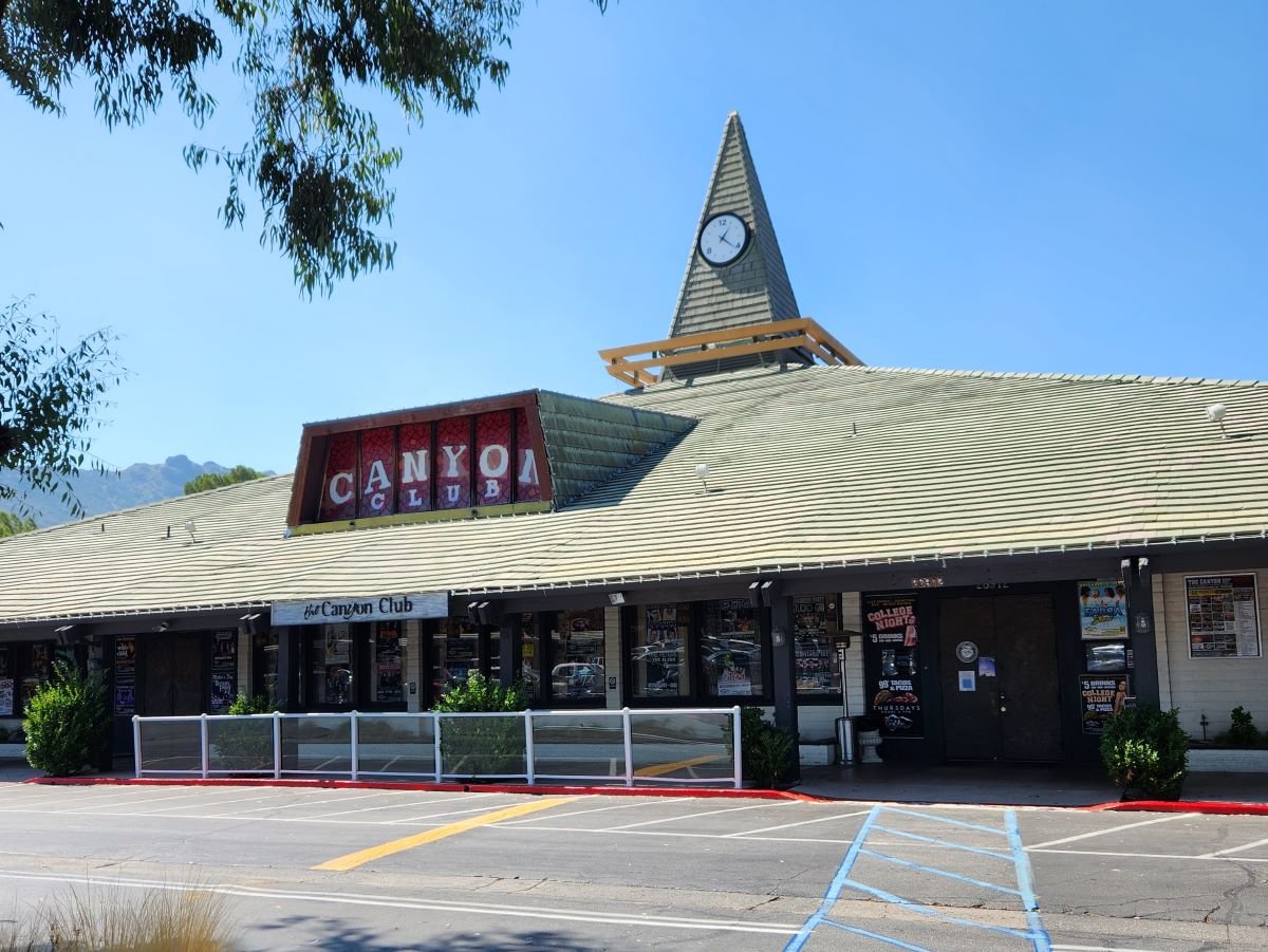
The Canyon Club in the Whizin Market Square at 28912 Roadside Drive, Agoura Hills is a live concert venue and supper club that host all types of bands and genres, comedy, special events and more. There are tables if you’re there to enjoy dinner too. Capacity is about 600. wheremusicmeetsthesoul.com/canyon-agoura-hills

Libbey Bowl is located in the heart of Ojai near the corner of Ojai Avenue and Signal Street. It was originally built in 1957 and has been used for the annual Ojai Music Festival, Storytelling Festival, Ojai Day event, holiday celebrations and many other community events through the years. It accommodates 1,300 people. www.libbeybowl.org.

The historic Arlington Theatre is located at 1317 State Street in Santa Barbara. Built in the mission revival style, it seats over 2,000 attendees. thearlingtontheatre.com

Free and Nearly Free Movies All Summer Long Around Ventura County 2024

bunnymoviescarrots1.jpg

Stay cool this summer of 2024 with several hundred free and nearly free ($1 to $6) movies in and around Ventura County and surrounding areas!

Rancho Simi Rec & Park District Movies in the Park on June 28 (Super Mario Bros Movie) and August 9 (Trolls) in Simi Valley and June 21 (The Little Mermaid) in Oak Park

City of Moorpark Movies in the Park on June 8, July 13 (Shrek), August 10 (Trolls) and September 14 (School of Rock) at Arroyo Vista Community Park.

Free Movies at the Park at Thousand Oaks Community Park on May 24, August 23 (Jumanji) and September 20 (Moana).

Free Movies in the Park in Camarillo on June 30 (DC League of Super-Pets), July 14 (Puss in Boots: The Last Wish), July 28 (Turning Red) and Aug 11 (Minions: The Rise of Gru).

Free Movie Nights at Ventura Harbor Village on July 20th (Barbie), August 17 (The Endless Summer) and September 21 (Hook).

City of Agoura Hills Summer Movies in the Park on June 8, July 13 (Super Mario Bros Movie) and July 27 (Coco).

Studio Movie Grill at the Simi Valley Town Center is offering $6 Children's Summer Movies (including small popcorn and small drink) Mondays through Thursdays from June 10 to August 8.

CineMalibu Summer Movies at Malibu Bluffs Park on July 27 (Space Jam) and August 17 (Teenage Mutant Ninja Turtles).

Free Movies at Warner Ranch Park in Woodland Hills on Saturday nights in August.

Free Movie in the Park at Berniece Bennett Park in Westlake Village on July 20th.

AMC Dine-In Thousand Oaks 14 hosts Summer Movie Camp - $3 family movies for 8 weeks - Mondays and Wednesdays at 11am and 2pm, from June 24 to August 14.

Regal Theaters in Thousand Oaks, Camarillo, Simi Valley and Calabasas present the Regal Summer Movie Express - $1 family movies on Tuesdays and Wednesdays June 11 to August 7 at 11am. https://www.regmovies.com/promotions/summer-movie-express

$3 Summer Movie Series at Plaza Stadium 14 in Oxnard feature $3 family movies at noon on Wednesdays, from June 26 to July 31.

Movies/dates subject to change. Contact organizers to confirm.

AND HOW ABOUT FREE CONCERTS IN AND AROUND VENTURA COUNTY

Identify Local Sex Offenders Using California Megan's Law Website

MegansLaw.jpg

California was the first state in the nation to initiate a Sex Offender Tracking Program in 1947, but until 1996, when California Megan's Law (CML) was initiated, information about sex offenders was not publicly available. 

Megan's Law is named after seven year old New Jersey girl Megan Kanka, who was raped and killed by a known molester who lived across the street from her family. All states now have a form of Megan's Law. On September 24, 2004, AB 488 was signed into law in California, providing the public Internet access to sex offender information at www.meganslaw.ca.gov.

This is a website that deserves a look, particularly by anyone who is a parent. While the website is not meant to "punish" sex offenders, it is a useful awareness tool. The search engine on the site allows you to search by name, address, city, zip and county, as well as within a two mile radius of parks and schools. You can also review the results of your search in both map and listing format.

Within seconds you can identify the 880=1 (as of July 2024) registered sex offenders in Ventura County, including photos, names, vital stats like date of birth, height and weight, their offenses and, where applicable, their addresses. You can view the offenders on a map or on a list.

Map view of megan’s Law offenders in Ventura County as of January 2023

The information in the CML database is not always up to date for each individual. The severity of the offenses for each individual vary from the more violent (rape, battery) to statutory rape, indecent exposure, etc.

Life's a Beach! Public Beaches Spanning From Carpinteria to the Ventura Harbor

Beach_Klotz.jpg

The beaches of Ventura County have something for everyone, be it the sand, the ocean breezes, surfing, volleyball, sunning, picnicking or just chilling out to the sound of the waves. Here we have compiled a listing of beaches just north of Ventura County in Carpinteria down the coast to the Ventura Harbor. Separately we highlight beaches stretching further down the coast through Oxnard, Channel Islands Harbor, Point Mugu and Malibu as well as up the coast in and around Santa Barbara.

The Santa Claus Lane Beach Area in Carpinteria is a south facing beach area popular with surfers, boogie boarders and sunbathers. Get there from the 101 by taking the Padaro Lane exit towards Santa Claus Lane, then taking a left on Santa Claus Lane. You can park in a small dirt area (there's room for maybe 10 cars there) on the ocean side or find street parking, which is plentiful. This is not an "official" beach to my knowledge, as in city or county-run. Just a private beach. No restrooms to my knowledge. Oh yes, you'll have to cross the railroad tracks...so be careful! Down the street is Padaro Beach Village, where you can grab a bite to eat and do a little shopping.

On a separate note, you may be wondering why it is called Santa Claus Lane. Well the old-timers among you (including me) know that a gigantic roadside Santa used to reside here that now greets us off the 101 freeway in the Nyeland Acres section of Oxnard. Learn more about the history at this link.

Surfers, boogie boarders, body surfers and frolickers at the Santa Claus Lane area beach.

Surfers, boogie boarders, body surfers and frolickers at the Santa Claus Lane area beach.

Just down the street is the quaint Padaro Beach Village, where you can grab a coffee, breakfast, lunch, do a little shopping, etc. Very relaxing little area.

Just down the street is the quaint Padaro Beach Village, where you can grab a coffee, breakfast, lunch, do a little shopping, etc. Very relaxing little area.

Carpinteria State Beach is a mile long beach for swimming, surf fishing, tidepool exploring and camping. Dogs are allowed only at the picnic area. The park originally opened in February 1932. There are four campground areas with 216 family campsites and seven group campsites available. Seals and sea lions can be seen in the area December through May, as well as an occasional gray whale. Tidepools contain starfish, sea anemones, crabs, snails, octopi and sea urchins. Exit the 101 at Casitas Pass Road, go west to Carpinteria Avenue, make a right at the signal; then turn left on Palm.  The beach is at the end of Palm Avenue near 4th Street. Call 805.968.1033 or visit www.parks.ca.gov/?page_id=599.

Note: Campfires are only allowed in the campground in fire rings provided. No fires are allowed on the beach.

CarpStateBeach_sign.JPG

Tar Pits Park in Carpinteria provides hiking and biking trails and a few benches, but no other park amenities.  Access to the park is very remote and it is suggested that you enter from the Carpinteria State Beach campgrounds or beach area.  Here you will see tar oozing out of the hills...so watch where you step! The Carpinteria Tar Pits is one of five natural asphalt lake areas in the world! Visit carpinteria.ca.us/parks-and-recreation/park-system for more information. The Carpinteria Harbor Seal Rookery can be reached by following trails east of the park.

Beach view from Tar Pits Park in Carpinteria.

Beach view from Tar Pits Park in Carpinteria.

Carpinteria Bluffs Nature Preserve is 53 acres of open space situated overlooking the Pacific Ocean is a series of walkways, trails and open space for ocean views, whale watching and fresh air. There are restrooms and I believe parking is free. This is not a beach for hanging out on the sand. Visit www.carpinteria.ca.us/parks_rec/park_system.shtml for more information. Take the 101 Freeway to Ballard Avenue and turn towards the ocean.

Rincon Beach Park is near the Ventura/Santa Barbara County line just a few miles east of Carpinteria. Just take the Bates Avenue offramp off the 101 Freeway to the ocean and on the right you'll find plenty of free parking and easy beach access, with picnic tables and restrooms. Just steps to the south of Rincon Beach Park is Rincon Point, known as one of the best surfing spots in the world.

Great photo opps here at Rincon Beach Park :)

Great photo opps here at Rincon Beach Park :)

South of Rincon Beach Park is a newer (premiered September 2014) Class I bike path that takes you through the La Conchita Beach area to Mussel Shoals. La Conchita Beach is low key, with several access points from the La Conchita Bike Path area. You can park at Rincon Point and bike or walk to one of several access points from the path. You can also drive into La Conchita, find a parking spot and take the newer undercrossing that'll get you to the beach by walking under Highway 101.  No restrooms or other facilities to my knowledge at the beach. It’s several miles of beauty, directly adjacent to the 101.

La Conchita Beach

La Conchita Beach

Mussel Shoals is a small beach community in Ventura with around 50 homes. There are about a dozen public parking spots along Old Pacific Coast Highway, paralleling the 101 near the Cliff House Inn. No restrooms. If you go there, perhaps have lunch at the Cliff House Inn and take in the peaceful views, while also checking out man-made Rincon Island.

Mussel Shoals

Mussel Shoals

The beach between Mussel Shoals on the northwest and Seacliff on the southeast is referred to Oil Piers Beach. There used to be piers here until they were taken down in 1998. You get here either via the La Conchita Bike Path or by taking the Seacliff Exit (#78) from Highway 101, then take Pacific Coast Highway northbound to Mobil Pier Road, where you will drive under the 101 to find parking (and if there's no spots available, go back to PCH and you'll find some). No facilities to my knowledge at this beach.

Oil Piers Beach Ventura

Hobson Beach Park is located north of Faria Beach Park and the Rincon Parkway, at 5210 W. Pacific Coast Highway, Ventura. It is managed by the County of Ventura. Day use parking is free but limited. Restrooms available. Limited beach space. Camping and RV spaces are available on a first come, first served basis. CLICK HERE for more info or call 805.654.3951.

Rincon Parkway is located between Faria Beach Park and Hobson Beach Park on Highway 1 off the Ventura Freeway at 5275 Pacific Coast Highway, Ventura. 127 parallel parking spaces are available for RV use only; no camping. All RV's must be fully self-contained units as there are no hookups, utilities, etc. Minimal beach, mostly rocks. Next to a train track. But nonetheless fun to stop by from time to time. No day use parking. CLICK HERE for more info.

Faria Beach Park is located south of Hobson Beach Park is another popular RV/camping spot at 4350 W. Pacific Coast Highway, Ventura. Also managed by the County of Ventura with spots available first come, first served. There are restrooms. No dogs on beach but they are allowed in camping areas. CLICK HERE for more info or call 805.654.3951.

South of Faria Park and north of Solimar Beach is an area referred to as Mondos Beach. We recently rode bikes from the Ventura Pier past this area and saw plenty of families enjoying the sand and the water. There is parallel parking available on the old highway. I believe there are also some porta-johns available.

Mondos Beach area in Ventura, south of Faria, north of Solimar.

Mondos Beach area in Ventura, south of Faria, north of Solimar.

There's a strip of beach along Old Highway 1 between Mondos Beach and Solimar Beach that has parallel parking available, with large rocks separate the street from the beach. I don't know the name of this beach, but it is there, open to the public. There's not a specific street address but it is in the proximity of 3456 Pacific Coast Highway.

Solimar Beach is a strip of beach between Faria and Emma Wood known for surfing, swimming and fishing. Park along Old Highway 1. No facilities. There are about 60 homes along this beach.

Emma Wood State Beach is popular for swimming, surfing and fishing.  The Ventura River estuary is at the mouth of the Ventura River at the southeast end of the park.  It attracts a variety of wildlife including raccoons, songbirds and great blue herons. Dolphins are occasionally seen just offshore. The park also features the crumbling ruins of a World War II coastal artillery site. Emma Wood offers family camping for self-contained vehicles only and group camping is available at Ventura River Group Camp. There are 90 campsites. There is a day use area in the park and beach access is available.  A bike path connects the park to Ventura and to the coast highway to the north. Parking is currently $10. Call 805.968.1033 or visit www.parks.ca.gov/?page_id=604. Directions at this link. Campfires not allowed on the beach.

We noticed a new sign at Emma Wood in the summer of 2015

We noticed a new sign at Emma Wood in the summer of 2015

The Downtown Ventura Promenade beachfront area stretches from Surfers' Point and Promenade Park at Figueroa Street and Shoreline Drive on the north, down the Promenade bike/walk path to the Ventura Pier. This is a popular area with lots of surfers, a cool kids' playground area just north of the pier and plenty of beach with lots of interesting looking rocks. There are several restrooms in the area. Great place to go bike riding with the family. Plenty of parking in the area on the north end. On the south side by the pier you may need to pay for parking at the Crowne Plaza on Harbor Blvd east of California Street or at San Buenaventura State Beach further east.

SurfersPointSign.JPG
VenturaPromenadeRocks.JPG

San Buenaventura State Beach stretches from the Ventura Pier down south past the homes of the Ventura Keys to Marina Park. There are two miles of sandy beach, sand dunes, picnic sites, fairly large parking lot, and the Jolly Oyster. Bike paths connect to other nearby beaches. Wheel Fun Rentals is located near the Ventura Pier if you need a bike. Campfires not allowed at this beach. Main parking lot access point is at San Pedro St and Pierpont Blvd. Additional parking in a lot off of Harbor Blvd north of Sanjon Road. Visit www.parks.ca.gov/?page_id=600 for more information.

Marina Cove Beach is a very popular family spot located at Marina Park, with a newer, small playground area, lots of parking (though weekends can get pretty packed), restrooms and a nice family-friendly beach.. Walk from Marina Park south to Soter Point for picnic areas, mermaid statue and more.

SanBuenaventuraSB.JPG
Fun stone jetty to navigate at the beach adjacent to Marina Park in Ventura.

Fun stone jetty to navigate at the beach adjacent to Marina Park in Ventura.

Harbor Cove Beach is located at the west end of Spinnaker Drive near Ventura Harbor Village and across from the Channel Islands National Park Visitor Center. It is a "still water" beach protected by jetties that is considered one of the safest family friendly beaches in the area (and also referred to as "Mother's Beach"). Restrooms and showers are available and across the street, next to the Visitor Center, is the Harbor Cove Cafe.

Harbor Cove Beach Lifeguard Station

Harbor Cove Beach Lifeguard Station

Surfer's Knoll Beach is located in Ventura adjacent from Ventura Harbor Village and as its name implies, is geared towards surfers, as well as others looking to relax and explore. Riptides are common here so be careful if you're a novice swimmer. There are restrooms and showers but no lifeguards on hand. Free parking!

And there you have it! Let's take a break for now but as mentioned above, beaches stretching further down the coast through Oxnard, Channel Islands Harbor, Point Mugu and Malibu are covered in this separate post!

But wait! Here's a compilation of beaches in the City of Santa Barbara and surrounding areas!

Formula (Chain) Business Ordinance Since 2007 in Ojai

Since December 2007, the City of Ojai has had what’s called a Formula Business ordinance which bans new retail establishments that have over a designated number of locations with similar features such as standard menus, merchandise, decor, signage, facade, etc. Basically it’s ban of large chains (e.g. Starbucks, McDonald’s, 7-Eleven, etc.) to ensure the city maintains its small town charm.

Initially the ordinance defined a Formula Business as over 10 locations; it has since been changed to five or more locations. For more information, review City of Ojai municipal code section 10-2.1713.

This ordinance covers the 4.37 square mile City of Ojai. It does not cover other communities in the greater Ojai Valley.

Mira Monte (Spanish for “mountain view”) is an unincorporated community of approximately 6,800 residents in Ventura County that is located southwest of Ojai. Since Mira Monte does not have its own post office, addresses in this community use Ojai.

Several CVG social media followers brought up this interesting point because there are some chain establishments located in Mira Monte that have an Ojai address, such as the new drive-in Habit Burger (opened July 17, 2024), Starbucks, McDonald’s, and Taco Bell. Although these chain establishments have an Ojai address, they are not subject to the City of Ojai Formula Business ordinance. And there ya have it.

Evolution of the Conejo Grade in Ventura County Over the Last 100 Years

Horseshoe shaped section of the Conejo Grade in the 1920s.

Horseshoe shaped section of the Conejo Grade in the 1920s.

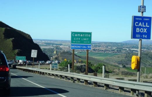
The Conejo Grade is the section of Highway 101 that connects the Conejo Valley with Camarillo. It is a four mile stretch of freeway with a significant 7% grade.

Going down the Conejo Grade from Newbury Park to Camarillo today.

Going down the Conejo Grade from Newbury Park to Camarillo today.

At 3:30 p.m. on the afternoon of May 1, 1937, a newly upgraded and realigned Conejo Grade premiered after a day of celebration commencing at the ranch of Adolfo Camarillo. Camarillo, the namesake of what in 1964 became the City of Camarillo, donated the right of way to enable the grade to be realigned. Actor Leo Carrillo entertained guests at Camarillo's ranch at the bottom of the grade.

Grand opening of the newly realigned Conejo Grade on May 1, 1937.

Grand opening of the newly realigned Conejo Grade on May 1, 1937.

The old Conejo Grade was constructed by the California Highway Commission in 1914-1915. The previous route had 49 twists and turns, making it somewhat hazardous to drive (albeit somewhat less steep than the current grade). The newly aligned Conejo Grade cut the number of curves by 75%.

Another view of the Conejo Grade before it was realigned in 1937.

Another view of the Conejo Grade before it was realigned in 1937.

The new 1937 Conejo Grade cost a total of $570,000, which is less than the average cost of a house in the Conejo Valley today! Over a year and a half, the project employed about 100 workers who put in over 272,000 hours, excavating over 800,000 cubic yards of mostly hard rock. Talk about rock stars!

In the 1950s and 1960s, Caltrans further widened and improved Highway 101 over the Conejo Grade.

In the 1950s and 1960s, Caltrans further widened and improved Highway 101 over the Conejo Grade.

Several decades later, as Ventura County grew and the cities of Camarillo and Thousand Oaks incorporated in 1964, Caltrans continued to widen and improve the highway to what it is today.

ConejoGrade2014_2.jpg

Source for historical information: "California Highways and Public Works" (May 1937) - official journal of the State of California Division of Highways, Department of Public Works.

Special thanks to the Pleasant Valley Historical Society for providing historic photos.