Simi Valley Cultural Arts Center

simi valley cultural arts.JPG

The Simi Valley Cultural Arts Center is a 220 seat theater at 3050 Los Angeles Avenue that hosts musicals, concerts, exhibits, children's theater and other events year-round.  The theater is a landmark Gothic structure built in the 1920s that was named as Ventura County Historical Landmark #67 in July 1981.  The building has served numerous purposes since inception and became the Cultural Arts Center in November 1995. 

For more information visit www.simi-arts.org or call 805.583.7905 (administrative office) or the box office at 805.583.7900.

Getty Center in Brentwood

Getty_front.JPG

Atop a 900 foot hill in the Santa Monica Mountains adjacent to the 405 freeway, Getty Center is a 24 acre complex that is one of the most visited museums in the United States. Getty Center opened in December 1997 and is part of the J. Paul Getty Museum, which has another location called The Getty Villa.

This is one of those "must absolutely see" places for every local resident and visitor to the Los Angeles area. It is a spectacular and pristine, inside and out.

Getty_bust.JPG

There are five main pavilions in the complex. The North Pavilion (on the immediate left after you walk through the Entrance Hall) contains pre-1700 art, including paintings on the upper level and sculptures and decorative arts, illuminated manuscripts and changing exhibitions on the main level. Adjacent to the North Pavilion is the East Pavilion, which contains paintings and sculptures and decorative arts from the 1600 to 1800 time frame.

The South Pavilion also contains art from 1600 to 1800. The West Pavilion contains art post-1800 as well as the Center for Photographs. Finally, the Exhibitions Pavilion contains rotating exhibitions.

Getty_View.jpg

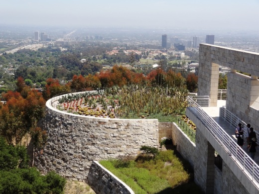
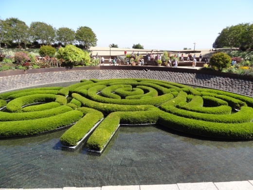
Stroll to the terraces on the south side of the complex and you'll be treated to panoramic views stretching to the San Bernadino Mountains, Century City, and the Pacific Ocean. You'll also be treated to a view of the Cactus Garden desert landscape in the South Promontory. The 134,000 sq ft Central Garden, large grassy area and stream leading into a pool with an azalea maze. You've got to see it to appreciate the beauty.

Getty_CactusGarden.JPG
Getty_Gardens.JPG
Getty_Azaleas.JPG

There are also outdoor sculptures throughout the complex, starting in the area where you wait for the tram that takes you up to the Center, in the Arrival Area in front of the Entrance Hall and in and around the restaurant and garden areas.

The Center displays some of the most recognizable pieces in the world from artists like Rembrandt, Van Gogh, Manet, Monet, Renoir, Gaugin, and so many others. The photography display is also outstanding.

Irises by Dutch artist Vincent Van Gogh

Irises by Dutch artist Vincent Van Gogh

There are several restaurants on the complex. I've eaten at the Garden Terrace Cafe located between the Exhibitions Pavilion and the Central Garden and it was good. Packaged, fresh sandwiches, salads, soups and other items are available.

To learn more, visit www.getty.edu/museum. Admission is free. Parking in the seven story underground lot near the bottom of Getty Center Drive is $15 ($10 after 3pm). Hours are 10am to 5:30pm Tuesday through Sunday.

There is a free tram that takes you to the top of the hill, or you can walk up the hill (it actually is not that bad, a 15 to 20 minute walk for most). Located at 1200 Getty Center Drive, Los Angeles.

I could go on and on...if you are not an art fan, don't worry. The views alone are worth the visit. But once you step foot in this amazing place you will be awestruck.

Arroyo Sequit Site - Santa Monica Mountains in Malibu Hills

NOTE: Arroyo Sequit has been closed until further notice as a result of the Woolsey Fire in November 2018. Updates at www.nps.gov/samo/planyourvisit/conditions.htm and www.nps.gov/samo/planyourvisit/arroyosequit.htm.

The National Park Service maintains a relatively small site called Arroyo Sequit in the Santa Monica Mountains, located at 34138 Mulholland Highway in Malibu. It is a bit off the beaten path, about 2 miles west of Decker Road. It is also easy to overlook coming from the east, as there doesn't appear to be a sign (like the sign below if you're coming east on Mulholland from the other direction).

Sign coming eastbound on mulholland; no such sign that I could find coming westbound.

Sign coming eastbound on mulholland; no such sign that I could find coming westbound.

The site features a 1 1/2 mile nature trail with rolling hills, wildflowers and I've been told a stream (though I did not find it in my visit there). 

Quite a small parking area at this remote location.

Quite a small parking area at this remote location.

It is quiet back here, so if you're looking for a peaceful stroll, check it out. It takes about 20 minutes to get to the Arroyo Sequit from the 101 via Westlake Boulevard/Decker Canyon.

CLICK HERE FOR OVER 50 LOCAL HIKES AND TRAILS IN VENTURA COUNTY AND SURROUNDING AREAS

There's an area with several benches that is used for astronomical observations. However, I contacted the college and was told it has been many years since these took place.

Southwest of the Arroyo Sequit you can see some very large satellite dishes. This is the Triunfo Pass Earth Station satellite tracking station owned and operated by AT&T. The three satellites measure 106 feet across and about 11 stories tall, so they are hard to miss!

Triunfo Pass Earth Station nearby

Triunfo Pass Earth Station nearby

Learn more about the Arroyo Sequit, including a site map, on the National Park Service website at www.nps.gov/samo/planyourvisit/arroyosequit.htm.

Point Mugu State Park

Point Mugu State Park is located in the Santa Monica Mountains, stretching from Newbury Park on the north to five miles of ocean shoreline on the south. The park includes 14,000 acres of land with over 70 miles of trails popular with hikers, cyclists and runners.  It is truly an amazing place, with rocky peaks that include the prominent Boney Mountain State Wilderness that looks over the western Conejo Valley.

The sign in Rancho Sierra Vista/Satwiwa in Newbury Park indicating you are entering State-managed Point Mugu State Park.

The sign in Rancho Sierra Vista/Satwiwa in Newbury Park indicating you are entering State-managed Point Mugu State Park.

You can actually hike, run or bike from Newbury Park, from the Rancho Sierra Vista/Satwiwa area managed by the National Park Service down to the ocean via Sycamore Canyon "Sycamore to the Sea," which is about an 8 mile trip one way. But do be aware - the initial 800 foot drop from Rancho Sierra Vista into the canyon via Big Sycamore Canyon Road is a bit more challenging coming back up.

The paved hill drops into the canyon via Sycamore Canyon Fire Road.

The paved hill drops into the canyon via Sycamore Canyon Fire Road.

There are four main canyons in Point Mugu State Park. Sycamore Canyon is perhaps the most well known, stretching practically the entire north/south length of the park, where at the bottom of the canyon you'll find the 58 space Sycamore Canyon Campground at 9000 W. Pacific Coast Highway (make reservations at ReserveCalifornia.com and search for “Point Mugu SP”).

The Sycamore Canyon Campground connects to the Sycamore Canyon Fire Road, which is your access point to a day of fun and adventure in Point Mugu State Park trails.

The Sycamore Canyon Campground connects to the Sycamore Canyon Fire Road, which is your access point to a day of fun and adventure in Point Mugu State Park trails.

The La Jolla Valley Natural Preserve is on the western side of the park, with a main access point near Thornhill Broome State Beach at the Ray Miller Trailhead to the La Jolla Canyon Trail which connects with the Loop Trail. Another access point to La Jolla Valley is the Chumash Trail trailhead, a rocky, steep trail across from Point Mugu Beach. La Jolla Valley was purchased by the State of California in 1966 and was established as a Natural Preserve in 1972.

Wood Canyon is in the northwest section of the park, where you will find the north/south running Wood Canyon Fire Road, which connects to the Guadalasca Trail, among others.

Serrano Valley is accessible from the south off the Big Sycamore Canyon Fire Road/Trail about a mile north of the beach. A beautiful, serene, area, with a connection to the Old Boney Trail that takes you to the Danielson Monument in the Boney Mountain Wilderness.

The main beach areas in Point Mugu State Park, running southeast to northwest, are Sycamore Cove, Thornhill Broome and Point Mugu. Sycamore Cove is a fun day-use park popular with families for gatherings with BBQ grills and picnic tables. Learn more about beaches in the Malibu area at this link.

This is the PCH overpass where on low tide you can walk underneath here to get from Sycamore Cove Beach to Sycamore Canyon Campgrounds and hiking in Point Mugu State Park. In higher tides, this area can be dicey, so be careful.

This is the PCH overpass where on low tide you can walk underneath here to get from Sycamore Cove Beach to Sycamore Canyon Campgrounds and hiking in Point Mugu State Park. In higher tides, this area can be dicey, so be careful.

If you are looking for beachfront camping, try Thornhill Broome Beach, with just over 60 spots available for RVs and tents. No hookups here and only porta-johns available, but can't beat the views! And across the street you can't miss the Giant Sand Dune!

Day use parking at the various sites is available for $12. There is very minimal street parking at Sycamore Cove but plenty of street parking adjacent to Thornhill Broome Beach.

Dogs on a leash are allowed in the Park's day use areas, campgrounds and beaches. Dogs are not allowed on the back country trails or dirt roads.

Keep driving northwest on PCH and you'll past the famous Mugu Rock and see Pt. Mugu Beach, which also has day use parking, with some parking on PCH. Learn more at the California State Parks website at www.parks.ca.gov/?page_id=630.

Mugu Rock up ahead, driving north on PCH from Thornhill Broome.

Mugu Rock up ahead, driving north on PCH from Thornhill Broome.

Lastly, let's cover some of the highest peaks in Point Mugu State Park. The Boney Mountain Wilderness Area, ever so prominent from the Conejo Valley, is located in the Park. But Boney Peak itself, at 2828 feet, is actually in the Circle X Ranch area managed by the National Park Service, along with Sandstone Peak, the highest spot in the Santa Monica Mountains at 3111 feet.

Boney Mountain range overlooks the western Conejo Valley.

Boney Mountain range overlooks the western Conejo Valley.

Other peaks include Tri Peaks at 3010 feet, Laguna Peak (the peak which has equipment from Naval Base Ventura County below), La Jolla Peak and Mugu Peak

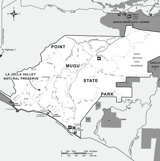
Map of Point Mugu State Park courtesy of National Park Service.

Map of Point Mugu State Park courtesy of National Park Service.

Hiking in the North Ranch Open Space in Thousand Oaks

The North Ranch Open Space is represented by several massive sections of nearly 2,600 acres located in the east side of Thousand Oaks. There is a section east of Erbes Road to Westlake Boulevard down to Hillcrest Drive on the west side (this area is referred to as the Hillcrest Open Space Preserve) as well as a section further east bounded by Westlake Boulevard on the west, Lindero Canyon Road on the east and Thousand Oaks Boulevard on south.

These hills are beautiful and quite prominent from throughout the Conejo Valley. Hiking, running and cycling these hills can be a challenge as they are quite steep in most sections.

A main trailhead into the North Ranch Open Space is on Bowfield Street, just east of the North Ranch Playfields. The trail is called the Saddle Pass Trail, winding up and down the hills south towards Thousand Oaks Boulevard.

There are various other neighborhood trail entry points throughout the vast area. One of these is located at Canyon Oaks Park, 6200 Hedgewall Drive, Westlake Village. There's a walkway and a small bridge that leads to a quite intense looking path up the hill. And indeed, it is a very steep path. Definitely not for everyone. This is a path into the Bowfield/Saddle Pass Trail, which is maintained by the Conejo Open Space Conservation Agency.

The Wishbone Trail is a loop trail into the North Ranch Open Space that starts and ends at Westlake Village Community Park, 31107 E. Thousand Oaks Blvd., Westlake Village. Trailhead is at the west end of the parking lot. You can connect to the Saddle Pass Trail from the Wishbone Trail via the Wishbone Connector trail.

Small COSCA sign at the bottom of the steep hill from Canyon Oaks Park leading into the North Ranch Open Space.

Small COSCA sign at the bottom of the steep hill from Canyon Oaks Park leading into the North Ranch Open Space.

A view of Canyon Oaks Park from about a third of the way up the hill.

A view of Canyon Oaks Park from about a third of the way up the hill.

There are roughly 3 or 4 miles of trails up here, mostly the Saddle Pass north/south trail but other connector trails to nearby neighborhoods, such as the townhome complex on Via Colinas above Thousand Oaks Blvd and the new Westlake Village Community Park and YMCA.

These hills get quite dry and hot during the summer months but in the spring green up nicely. You may even get the opportunity to enjoy some wildflowers.

Orange beauties can often be seen in the March time frame off the Saddle Pass Trail south section.

Orange beauties can often be seen in the March time frame off the Saddle Pass Trail south section.

Here's another section of trail that connects homes off of Via Colinas into the North Ranch Open Space. Most of these connector trails are quite steep, though generally well maintained!

Here's another section of trail that connects homes off of Via Colinas into the North Ranch Open Space. Most of these connector trails are quite steep, though generally well maintained!

California poppies on March 16, 2019.

California poppies on March 16, 2019.

Tarantula Hill in Thousand Oaks

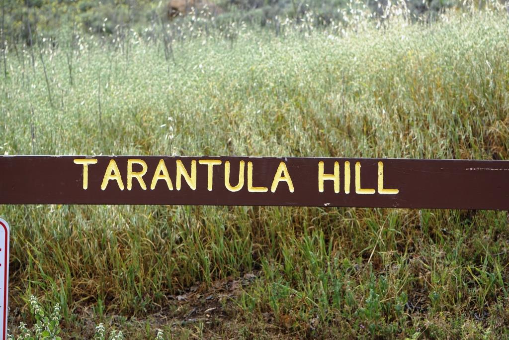
Tarantula Hill is located off of West Gainsborough Road in Thousand Oaks, between Grand Oak Lane and Camino Manzanas. Just park your car by the prominent oak tree and little green sign. The hill is named after the spiders that inhabit this peak that happens to be the highest point within the Conejo Valley, at about 1,057 feet.

I've seen people run, walk and cycle up the paved service road to the top, where you get treated to panoramic views of the entire Conejo Valley. The cyclist was working it pretty darn hard to get up there...the hill it pretty steep...about a 250 foot climb.

There’s also a couple ways to get near the top via trail. Look for the path on the east side of the hill, accessible from Gainsborough.

There's a single bench on the west side at the top and a water reservoir fenced in with barbed wire is quite prominent. For a quick dose of views, Tarantula Hill aims to please.

The bench at the top of Tarantula Hill faces west towards Newbury Park.

The bench at the top of Tarantula Hill faces west towards Newbury Park.

Tarantula Hill is dedicated open space that is protected by the Conejo Open Space Conservation Agency. Visit www.conejo-openspace.org for more information.

TarantulaHill2.JPG
The hill greens up nicely in the spring.

The hill greens up nicely in the spring.

TarantulaHill3.jpg

K1 Speed Indoor Go Kart Racing in Thousand Oaks

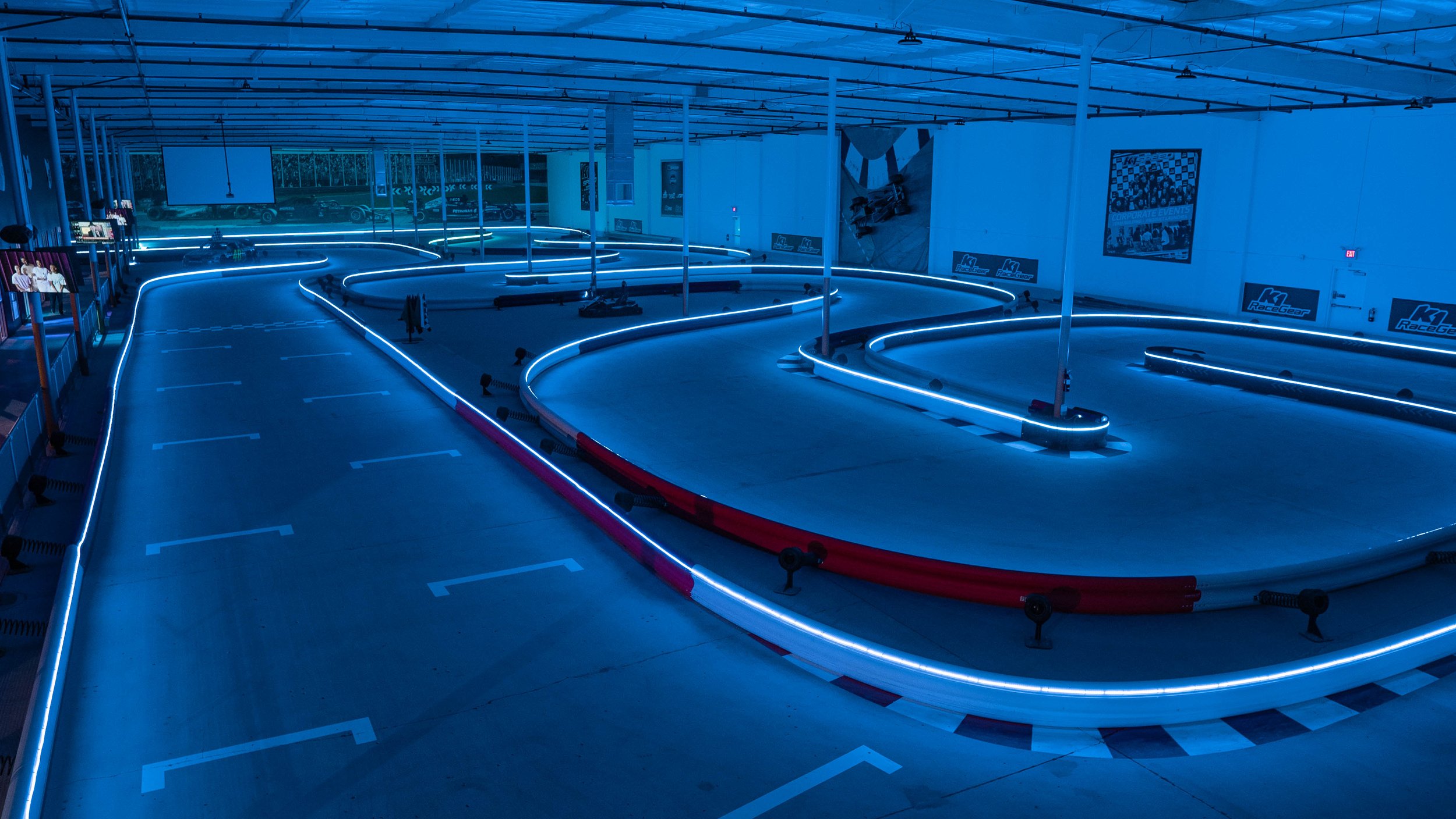
K1 Speed indoor go kart racing opened its 8th Southern California location - K1 Speed Thousand Oaks, in February 2022

Guests can enjoy indoor go kart racing, games for all ages, food and drinks, and a private event room for any occasion.

The all-electric Adult Karts for adults and teens can reach speeds of up to 45 mph. Kids 4’ (48”) or taller can drive electric Junior Karts that can reach up to 20 mph on the professionally designed circuit.

Guests can also play over 30 popular video games from the past and present, plus pool tables, air hockey, basketball hoops and prize machines.

The Paddock Lounge is an onsite café that serves classic favorites such as hamburgers, pizza, nachos, and wings in addition to a wide assortment of non-alcoholic beverages. In the near future, this location plans to serve beer & wine for adults 21 years of age and older to enjoy after racing.

A private event room for birthdays, corporate events, bachelor parties, and other group events is also available. For private events, the entire venue may be rented by the hour, half-day, or full day.

K1 Speed Thousand Oaks is open seven days a week at 770 Lawrence Drive. Reservations are not required to race.

More information at www.k1speed.com/thousand-oaks-location.html.

A portion of the arcade at K1 Speed Thousand Oaks

Rincon Point in Carpinteria

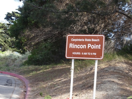
RinconPoint_sign.JPG

Rincon Point is home to one of the most popular surfing spots in the world. Accessible near the Ventura/Santa Barbara County line just a few miles east of Downtown Carpinteria. Take the Bates Avenue offramp off the 101 Freeway towards the ocean. On the right is access to the City of Carpinteria's Rincon Beach Park and on the left is access to the Rincon Point parking area. Open 6am to 9pm daily, with a not-particulary-nice porta-john available in the parking area.

There is a trail that takes you to the beach area from the parking lot. The area is also surrounded by beach homes.

A view toward the north from Rincon Point (in the direction of Rincon Beach Park).

A view toward the north from Rincon Point (in the direction of Rincon Beach Park).

THE BEACH BOYS INCLUDED A REFERENCE TO RINCON IN SURFIN' SAFARI:

At Huntington and Malibu

They're shooting the pier

At Rincon they're walking the nose

We're going on safari to the islands this year

So if you're coming get ready to go

Boney Mountain Trail to Hidden Valley Overlook, Danielson Monument and Waterfall

At Rancho Sierra Vista/Satwiwa in Newbury Park is a nice assortment of trails that reward hikers with beautiful views and peaceful surroundings.  Find your way to the Satwiwa Native American Culture Center and from there walk up Big Sycamore Canyon Road where you'll reach a fork in the road. If you go straight you'll be taking Big Sycamore Canyon road about 6-7 miles down to Sycamore Canyon Campground and Sycamore Cove Beach. The road is paved for about 3 miles until it intersects the Backbone Trail, at which point it is dirt trails to PCH.

Benches at the top of Big Sycamore Canyon Road.

Benches at the top of Big Sycamore Canyon Road.

Views from the benches looking down Big Sycamore Canyon. Photo taken a few months before the Springs Fire of 2013.

Views from the benches looking down Big Sycamore Canyon. Photo taken a few months before the Springs Fire of 2013.

View of Big Sycamore Canyon after the Springs Fire of 2013.

View of Big Sycamore Canyon after the Springs Fire of 2013.

Getting back to the benches at the top of Sycamore Canyon, looking off to the east you'll find the Boney Mountain Trail sign that takes you towards the Hidden Valley Overlook, Waterfall and Danielson Monument, a .4 mile, 1 mile and 2.2 mile one way hike, respectively.

BoneyMountainTrailMarker.JPG
Boney Mountain Trail sign in Rancho Sierra Vista post-Springs fire 5/5/13.

Boney Mountain Trail sign in Rancho Sierra Vista post-Springs fire 5/5/13.

Take the trail to the fork in the road. A sharp left takes you directly back to the Satwiwa Center, a "normal" left takes you on a trail towards Wendy Drive and/or back to the Satwiwa Center in a loop, and a right turn takes you up the hill towards the destinations mentioned above.

A short walk up the trail gets you to yet another bench that overlooks Sycamore Canyon from another angle. This is called the Sycamore Canyon Overlook.

This photo of the Sycamore Canyon Overlook was taken before the Springs Fire of 2013.

This photo of the Sycamore Canyon Overlook was taken before the Springs Fire of 2013.

Bench at Sycamore Canyon Overlook on 5/14/13.

Bench at Sycamore Canyon Overlook on 5/14/13.

The rocky trail from there takes you to a fork. Veer LEFT to the Hidden Valley Overlook trail or right to the Danielson Monument and Waterfall (as well as the Old Boney Trail).

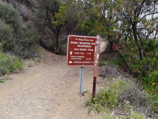
BoneyMountainSign.JPG

The Hidden Valley Overlook trail is rocky, pretty steep in some sections and a bit challenging. But...you will be rewarded with some nice views of Dos Vientos, Camarillo and eventually an "overlook" of Hidden Valley.

Endpoint of the Hidden Valley Overlook trail, peering into Hidden Valley. This photo was taken in April 2014.

Endpoint of the Hidden Valley Overlook trail, peering into Hidden Valley. This photo was taken in April 2014.

If you veer right at the fork in the trail, after a .4 mile jaunt down the hill you'll see a sign that tells you you're getting close the waterfall. There are lots of rocky sections as well as crevices as you make your way down this trail, so do be careful. But it is fairly wide most of the way.

Sign at bottom of hill indicating you distance to waterfall trail and danielson monument

Sign at bottom of hill indicating you distance to waterfall trail and danielson monument

There's a stream crossing that most of the year is easy to get across as there's not a lot of water in it, although in particularly rainy winters it can get more challenging in the winter/spring.

Mostly mud in the stream crossing that gets you to the Danielson Monument in mid-February 2013, but some years there's more water in there (like 2017, after the winter rainstorms).

Mostly mud in the stream crossing that gets you to the Danielson Monument in mid-February 2013, but some years there's more water in there (like 2017, after the winter rainstorms).

So after you cross the stream, you're off on a mostly narrow, single-track trail. Watch out for poison oak on the sides of the trails. I usually run up here in shorts, but you're much safer wearing long pants. The next juncture in the trail, you go straight to the waterfall, or veer right up to the Danielson Monument.

We've been to the waterfall when it had a lot of water flowing in it. This year (2013) there's barely a trickle.

We've been to the waterfall when it had a lot of water flowing in it. This year (2013) there's barely a trickle.

So if you take the sharp right hand turn, you're on your way to the Danielson Monument (a tribute to Richard Ely Danielson, Junior, who lived on land in this area for 32 years with his family, until it was sold to the National Park Service in 1980). Awesome views from several vantage points as you head up the trail. A bit of a climb. Be prepared! Check out other photos of the monument HERE and larger pics HERE.

Danielson Monument

Danielson Monument

About 4/5ths of the way from the bottom of the canyon to the Danielson Monument, you can veer right to the Old Boney Trail, an interesting, mostly single track trail that has great views of Boney and intersects with the Fossil Trail.

Here's the sign at the juncture of the Danielson Road trail and the Old Boney Trail turnoff, about .3 mile away from the Danielson Monument.

Here's the sign at the juncture of the Danielson Road trail and the Old Boney Trail turnoff, about .3 mile away from the Danielson Monument.

Los Angeles Zoo and Botanical Gardens

LAZoo_logo.png

The 133 acre Los Angeles Zoo and Botanical Gardens first opened in 1966. The Zoo is home to more than 2,200 mammals, birds, amphibians and reptiles representing more than 270 different species of which more than 58 are endangered. In addition, the Zoo’s botanical collection comprises several planted gardens and over 800 different plant species with over 7,400 individual plants. The Zoo receives over 1.8 million visitors per year and is owned and operated by the City of Los Angeles.

There's a children's zoo area with a petting zoo and fun exhibits. There's also a play area for kids that is quite popular.

Some advice! The line to get into the park can get pretty long on weekends. My advice is to buy an L.A. Zoo Membership! There is a $150 one-year family membership (as of January 2022) that gives you FREE admission for 2 adults and all of your kids or grandkids ages 2-17.  If you have a family of 4 and visit the park twice a year, this membership SAVES YOU MONEY as the regular entry cost is $22 for adults and $17 for ages 2 to 17. Ages 62+ is $19. (Pricing as of January 2022.) Plus, there was NO LINE to get in with your membership card! That alone gave us an extra 30 minutes in the park today. 

Zoo membership also gives you free or discounted admission to zoos and aquariums across the country, including 50% off at the Santa Barbara Zoo!

The Living Amphibians, Invertebrates, Reptiles (LAIR) exhibit opened in March 2012. There is a damp forest section that has Fiji Island banded iguanas, poison dart frogs, Guatemalan palm vipers and Fly River turtles, an area where you can watch staff taking care of the animals, tortoises, lizards, crocodile swamp, desert reptiles and much more. We also learned that Mexico has more reptile species than any other country on earth.

The L.A. Zoo is located at 5333 Zoo Drive, Los Angeles. Visit www.lazoo.org for more information.

LAZoo_sign.jpg
Hippo relaxing at the Los Angeles Zoo

Hippo relaxing at the Los Angeles Zoo

Nicely appointed kids' play area at Los Angeles Zoo

Nicely appointed kids' play area at Los Angeles Zoo

Rhino at Los Angeles Zoo is just kickin' it

Rhino at Los Angeles Zoo is just kickin' it

Zebra at Los Angeles Zoo is having a snack

Zebra at Los Angeles Zoo is having a snack

Lair2.JPG

Community Classes at Conejo Valley Adult Education in Thousand Oaks

Conejo Valley Adult Education offers a wide range of classes in Foreign Language, Food and Nutrition, Decorative and Fine Arts and Home and Garden. Additionally, the school conducts vocational training programs for the medical community and for careers in the private business sector. The school is part of the Conejo Valley Unified School District. 

Visit www.ConejoAdultSchool.org for more information and for the current class catalog. The campus is located at 1025 Old Farm Road, Thousand Oaks.

Murphy Auto Museum - Oxnard (CLOSED IN JULY 2024)

NOTE: The Murphy Auto Museum shut its doors on July 7, 2024.

MurphyAutoMuseum_logo.png

See a collection of dozens of vintage and classic cars at the Murphy Auto Museum, 1930 Eastman Avenue in Oxnard .

The suggested donation to the museum is $10 for adults. Children 12 and under are free. Active military with ID or in uniform are also free.  Open year-round on Saturdays/Sundays from 10am to 4pm. April through December, the museum is also open on Fridays from 10am to 4pm.

Murphy1.jpg
Murphy2.jpg