Mullin Automotive Museum in Oxnard (CLOSED)

On January 17, 2024, the Mullin Automotive Museum closed its doors on Saturday, February 10th, in light of the passing of Peter Mullin in September 2023. More information at THIS LINK.

MullinAutomotiveMuseum_building.JPG

Located at 1421 Emerson Avenue in Oxnard, the Mullin Automotive Museum is a 47,000 square foot facility that displays a collection of over 50 French Art Deco cars from the 1930s and 1940s. The museum opened its doors in the spring of 2010. Models from Bugatti, Delage, Delahaye, Hispano Suiza, Talbot-Lago and Voisin are on display on a rotating basis from a collection of over 140 vehicles. The Mullin collection also displays unique pieces of furniture, decor, paintings and photographs from that era.

The museum is open 10 a.m. to 3 p.m. Fridays and Saturdays.

Visit www.mullinautomotivemuseum.com or call 805.385.5400 to learn more and to purchase tickets in advance (required). As of January 2024, admission is $16 for adults, $14 for 65+, veterans and students 13-17, $10 for ages 3 through 12 and free for 2 and under. Active military FREE with military ID.

This museum and its contents are STUNNING, to say the least!! More photos at THIS LINK.

Peter W. Mullin founder of the museum, passed away on September 18, 2023.

Mullin1.jpg
Mullin2.jpg
Mullin3.jpg

The Ultimate Escape Rooms at Ventura Harbor Village

The Ultimate Escape Rooms are a recent addition to Ventura Harbor Village. There are four different themed rooms that a group of up to eight people are have to escape within a 60 minute time frame.

But how? The room is full of puzzles, riddles and props that the group must decipher to come up with the ultimate "code" to escape the room. Using the combined efforts of your group, you must review the clues and solve a series of puzzles to make your way out of there.

Yes, I have tried it with a group of 11 to 14 year old kids and we had a fun time trying to get out of there. Although we were unable to figure out the final piece to our puzzle, we enjoyed it. And don't worry...if the group needs clues, you can all raise your hands and you will be given a bit of help.

They do not allow you to bring personal belongings like cell phones into the rooms, but lockers are provided. 

Learn more at www.theultimateescaperooms.com.

Ventura Harbor Village

VentHarborVillage2.jpg

Ventura Harbor Village at 1583 Spinnaker Drive, Ventura is home to 33 acres of harborside activities, shopping and restaurants.  The weather is always so cool over there it makes for a nice retreat.

Go for a walk along the boardwalk or at the beach or enjoy activities like kayaking, sailing, pedal boats, sport-fishing and cruises. Ventura Harbor Village hosts events and activities year-round, including music performances, kids' activities, themed events, festivals and more.

VentHarborVillage1.JPG
VentHarborVillage3.jpg

Eateries at Ventura Harbor Village include Andria's Seafood Restaurant, Baja Bay Surf N' Taco, Boatyard Pub, Brophy Bros. Clam Bar & Restaurant, Coastal Cone Ice Cream, Deep Sea Wine Tasting Room, Le Petit Cafe, Bakery & Restaurant, Margarita Villa Mexican Restaurant, On The Alley, Sugar Lab Bake Shop, The Greek Mediterranean Steak & Seafood and The Parlor. You won't go hungry here.

The Channel Islands National Park Visitor Center is located adjacent to Ventura Harbor Village. Free admission and an awesome resource for learning more about the Channel Islands and its protected habitat.

Island Packers at the Harbor has numerous boat rides and is the only authorized concessionaire to transport folks to Channel Islands National Park. 

Ventura Boat Rentals rents out electric boats, paddle boats, kayaks, power boats and charters cruises in the Ventura Harbor.  So much fun to be had!

VHarbor Kayaking.jpg

Across the street from Ventura Harbor Village is beach access at Harbor Cove Beach (a safe beach protected by jetties) and Surfer's Knoll Beach. Local area beaches at THIS LINK.

More information at www.venturaharborvillage.com or call 805.642.8538 (or 877.89.HARBOR).

Los Robles Trail System in Thousand Oaks

LosRoblesTrailSign.JPG

The Los Robles Trail winds from Potrero Road, just east of Wendy Drive in Newbury Park, to Foothill Drive near Fairview Road (near Hampshire Road in Westlake Village). A popular access point is at South Moorpark Road and Greenmeadow Avenue in Thousand Oaks.

Along with its many connecting trails (Triunfo Canyon Trail, Rosewood Trail, White Horse Canyon Trail, Los Padres Trail and more), awesome opportunities abound for hikers, bikers and equestrians to enjoy the open space.

If you're looking for an easy, one mile trail hike with the kids, the Oak Creek Canyon Loop is a nice one to do. There is also a unique Interpretive Trail at Oak Creek Canyon Loop that is accessible to handicapped/wheelchairs and blind individuals! Or extend the Oak Creek Canyon Loop to an easy 3 mile hike to the Los Robles Nature Walk. Also, the 1 mile Spring Canyon Trail is an excellent choice for families with young children.

OakCreekCynLoop_sign.JPG

For some of the most spectacular views of the Conejo Valley, try hiking up to Angel Vista Peak in Newbury Park.

A rugged, single track trail popular with mountain bikers and hikers is the Los Robles Trail West that goes up "Space Mountain" in Thousand Oaks. And Los Robles Trail East is another nice hike accessible from several points.

This nearly 2,000 acre ridgeline trail system with its many neighborhood feeder trails is located at the southern portion of the Conejo Open Space. The Los Robles Trail also traverses several open space areas including Los Padres, Los Vientos, Conejo Ridge. Hope Nature Preserve, Old Conejo, Deer Ridge, Rancho Potrero and Ventu Park.

Additional Los Robles Trail trailhead points west of the Rosewood Trail trailhead to Angel Vista Peak include Felton Street, east of Lynn Rd in Newbury Park (end of cul de sac) and Potrero Road, about 1/4 mile east of S Wendy Drive in Newbury Park (parking lot available).

Views from Angel Vista Peak are iconic.

Views from Angel Vista Peak are iconic.

To the west of Los Robles is Rancho Sierra Vista/Satwiwa and Point Mugu State Park which creates a public backcountry of over 27,000 acres of open space that stretches to the Pacific Ocean at Sycamore Cove. This scenic region is part of the Santa Monica Mountains National Recreation Area and provides panoramic views of Hidden Valley, the Conejo Valley and the Channel Islands.

Los Robles Trail trailhead and parking area on Potrero Road in Newbury Park.

Los Robles Trail trailhead and parking area on Potrero Road in Newbury Park.

The Los Robles Trail has historical significance. On February 28, 1776, Juan Bautista de Anza and his band of 198 settlers came through the Conejo Valley on their way from Mexico to San Francisco. Though the 101 freeway is the actual route, the National Park Service has designated the Los Robles Trail as the official recreational route so that everyone can enjoy the only national historical trail in the state of California.

Approximately 25 miles of trails provide a contiguous route from Westlake Village to Newbury Park with several shorter loops into narrow canyons and up steep ridges. The adjoining open space areas are managed by the Conejo Open Space Conservation Agency (COSCA), a joint powers authority created by the City of Thousand Oaks and the Conejo Recreation and Park District in 1977.

Unless you are an ant, this Los Robles Trail map is too small to read...click it for a full-size pdf map!

Unless you are an ant, this Los Robles Trail map is too small to read...click it for a full-size pdf map!

For more information about the Los Robles Trail, visit the Conejo Open Space Foundation website at cosf.org/trails/los-robles.

Santa Clara River Valley Railroad Historical Society's Railroad Visitor Center in Fillmore

SCRVRailroad_logo.gif

The Santa Clara River Valley Railroad Historical Society was established in 1993 to help preserve and restore the railroad corridor between Montalvo and Saugus. This corridor, known as the Southern Pacific Santa Paula Branch, is a unique and historical local community asset.

Stop by the Railroad Visitor Center, located at 455 Main Street, Fillmore, on Sundays between noon and 3 p.m. (or by appointment) and check out historical artifacts, information and photographs, a large model train setup, gift shop, theater and more.

More information at www.scrvrhs.com or call 805.524.2254.

We stopped by the Sespe Creek Car Show at Fillmore & Western yesterday (4th of July) and while we were there walked into the Santa Clara River Valley Railroad Historical Society Railroad Visitor Center at 455 Main Street, Fillmore. We've been in here several times before with the model trains all running and the kids sit there mesmerized by them.

Spring Canyon Trail Hike in Thousand Oaks

The Spring Canyon Trail is a short, fairly easy hike in the Newbury Park/Thousand Oaks section of the Los Robles Trail system that is great family fun.

Although a good portion of the Spring Canyon Trail is flat like this, there definitely are some moderately hilly sections.

Although a good portion of the Spring Canyon Trail is flat like this, there definitely are some moderately hilly sections.

This one mile trail runs east from the vicinity of Lynn Oaks Park, 359 Capitan Street, Newbury Park as well from the eastern terminus of Hemlock Lane, at Heavenly Valley Road in Newbury Park (in the Ventu Park community) to a juncture where you can either continue straight ahead for about a half a mile towards the Los Robles Trail access point at South Moorpark Road and Greenmeadow Avenue in Thousand Oaks or veer up "Space Mountain" on the right. (The views at the top of Space Mountain are awesome but this is a bit of a climb and is very popular with mountain bikers...probably not the best direction with little ones).

The path that takes you from Lynn Oaks Park to the Spring Canyon Trail.

The path that takes you from Lynn Oaks Park to the Spring Canyon Trail.

Sign above Lynn Oaks Park that tells you that to the left is Los Robles Trail and to the right is the Hemlock Lane gate in Ventu Park.

Sign above Lynn Oaks Park that tells you that to the left is Los Robles Trail and to the right is the Hemlock Lane gate in Ventu Park.

Out and back you can make this a 2 to 3 mile moderate hike or more if you add in the Oak Creek Canyon Loop or Los Robles Nature Walk.

Sign at the east terminus of Spring Canyon Trail indicating Moorpark Road is half a mile away. Behind me is the trail toward "Space Mountain" and Los Robles Trail going east towards Newbury Park.

Sign at the east terminus of Spring Canyon Trail indicating Moorpark Road is half a mile away. Behind me is the trail toward "Space Mountain" and Los Robles Trail going east towards Newbury Park.

You can also park your car at the Moorpark Road/Greenmeadow trailhead and make your way west towards the Spring Canyon Trail and perhaps eat lunch or snack at Lynn Oaks Park (which by the way also has a nice playground area, basketball court and more...but no restroom however).

Paramount Ranch Recreation Area in Agoura

The Woolsey Fire in November 2018 destroyed the historic structures at Paramount Ranch described below. However, there is a plan to rebuild four of the structures in 2023-2024. More information at www.nps.gov/samo/learn/historyculture/paramount-past-present-and-future.htm.

ParamountRanchWoolsey.JPG
Paramount Ranch Western Town Aerial View (Courtesy NPS)

Paramount Ranch Western Town Aerial View (Courtesy NPS)

Paramount Ranch is located in Agoura off of Cornell Road, between Kanan Road and Mulholland.  Click here for a map in a pdf file on the National Park Service website.

Paramount Pictures originally purchased 2,700 acres here for use as a "movie ranch" in 1927 and since then, hundreds of movies and TV shows have been filmed there.  A permanent western town was built on the site in the early 1950s using old Paramount Pictures props.  Before the Woolsey Fire of 2018, you could walk freely around these old sets.

Before the Woolsey Fire of November 2018.

Before the Woolsey Fire of November 2018.

The Western Town sign and bridge is still there but most everything surrounding it is burnt after the Woolsey Fire of November 2018.

The Western Town sign and bridge is still there but most everything surrounding it is burnt after the Woolsey Fire of November 2018.

ParamountRanchPic1.JPG
Western Town at Paramount Ranch destroyed in the Woolsey Fire.

Western Town at Paramount Ranch destroyed in the Woolsey Fire.

ParamountRanch2.JPG
A beacon of hope. Two structures were unharmed in the Woolsey Fire - this church building seen in the TV series “Westworld” and the train station.

A beacon of hope. Two structures were unharmed in the Woolsey Fire - this church building seen in the TV series “Westworld” and the train station.

ParamountRanch3.JPG

A list of movies filmed at Paramount Ranch is here.  These include films like The Last Outlaw (Gary Cooper), The Virginian (Gary Cooper), Tom Sawyer, Huckleberry Finn (Jackie Coogan), Million Dollar Legs (W.C. Fields), Adventures of Marco Polo, Remember  the Night (Barbara Stanwyck) and many more.  From 1992 to 1997, the TV show, Dr. Quinn, Medicine Woman (featuring Jane Seymour) was filmed there.

Beyond the western town, there are plenty of hiking trails at the park.  More information at www.nps.gov/samo/planyourvisit/paramountranch.htm or call the NPS at 805.370.2301.

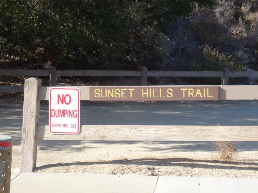
Sunset Hills Trail in Thousand Oaks

SunsetHillsTrail_sign.JPG

The Sunset Hills Trail is easily accessible off of Erbes Road in Thousand Oaks, just 7/10ths of a mile north of Sunset Hills Boulevard, just past Fernleaf Court.

There's a triangular dirt parking lot on the east.

There's a triangular dirt parking lot on the east.

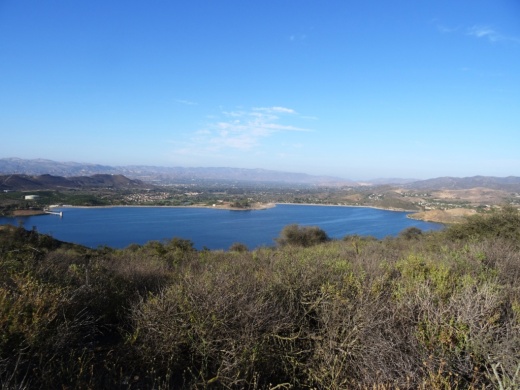
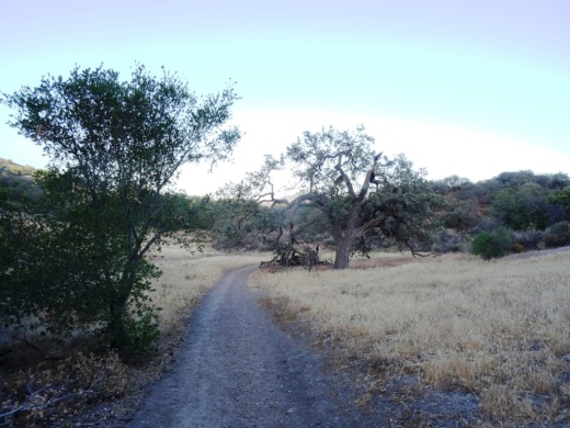
This is a pretty easy mile or so trail that takes you past the Bard Lake Reservoir. The reservoir is of course is fenced in but you'll be treated to its beauty as you make your way up. Lake Bard is owned by the Calleguas Water District for storage of up to 10,000 acre-feet (3.3 billion gallons) of water used to meet peak summer demand and emergency requirements.

SunsetHillsTrail2.JPG

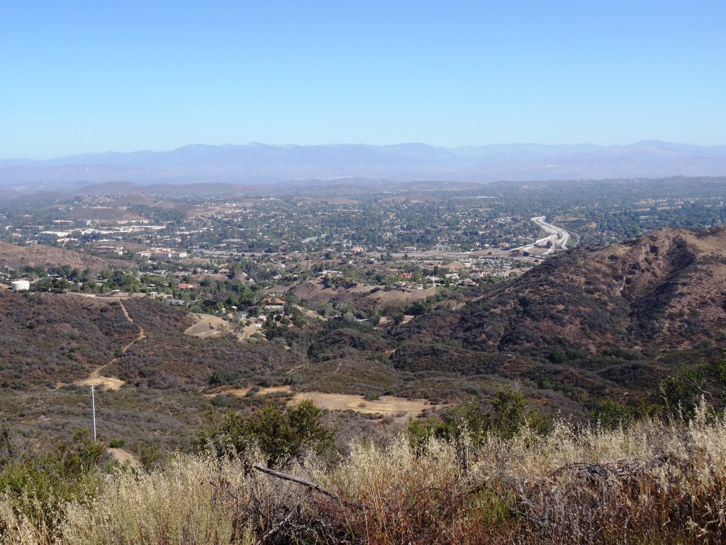
In fact, most all the way up this fairly gentle, hilly slope, you'll get some great panoramic views of the entire area, including the Conejo Valley, Simi Hills and looking west towards Camarillo/Oxnard. Continue east and you will reach the Woodridge Open Space in Thousand Oaks.

SunsetHillsTrail1.JPG
SunsetHillsTrail4.JPG

The Sunset Hills Trail is maintained by the Conejo Open Space Foundation. More information at cosf.org/trails/other-trails/easy-hike-sunset-hills-trail.

SunsetHillsTrail5.JPG

An additional, and perhaps more popular hike provides even better view of the Bard Reservoir. Take the additional loop in the shape of Maine (kind of) either clockwise or from the first juncture or counterclockwise after cresting the hill. If you go to the top of the hill take the trail on the left and continue onwards. You will see some steps and a bench to take in the views along the way.

(Map courtesy of the conejo Open Space Foundation) Green highlighted section is a nice loop to hike - good family hike.

After cresting the first hill from Erbes Road, find the loop trail on the left.

After cresting the first hill from Erbes Road, find the loop trail on the left.

A short walk to this bench that overlooks Bard Reservoir.

A short walk to this bench that overlooks Bard Reservoir.

Continue on the trail until it loops around and goes south., parallel to Highway 23

Continue on the trail until it loops around and goes south., parallel to Highway 23

Soon you will be back at the main trail, passing through this tree-tunneled section.

Soon you will be back at the main trail, passing through this tree-tunneled section.

Triunfo Canyon Trail in Westlake Village

TriunfoCanyon_sign.JPG

If you are looking for peaceful trails and outstanding panoramic views of the Conejo Valley from Thousand Oaks to Westlake Village, Hidden Valley and beyond, take a look at the Triunfo Canyon Trail, accessible from Triunfo Community Park, Triunfo Canyon Road at Tamarack Street in Westlake Village.

TriunfoCanyon1.JPG

The trailhead is on the northwest end of the park, near the tennis courts. It is a beautiful, winding, single track canyon trail for most of the first mile or so, then links up to the main Los Robles Trail and utility road, which is much wider.

Views of the Westlake Lake area from the Triunfo Canyon Trail.

Views of the Westlake Lake area from the Triunfo Canyon Trail.

You'll discover some steps to a bench at the top offering a birds eye view of the surrounding areas. It really is spectacular up there and the images here don't come close to doing the view justice.

Bench at the top of the hill allows you to catch your breath and take in the sights.

Bench at the top of the hill allows you to catch your breath and take in the sights.

From the bench, either turn around and go back down the hill or continue your way on if you'd like to the Los Robles Trail, above the Los Padres Trail.

One thing I'll say about these trails is that they seem particularly rocky, so wear decent shoes, as you don't want to twist your ankle. A bit of a climb to get up there; about 1,000 feet.

Learn more about the trail on the Conejo Open Space Foundation website at cosf.org/trails/los-robles/los-robles-moderate-hike-triunfo-park-to-east-los-robles-trail.

TriunfoCanyon6.JPG

Janss Marketplace in Thousand Oaks

Janss Marketplace in Thousand Oaks

Janss Marketplace at 275 North Moorpark Road in Thousand Oaks (corner of Moorpark Road and Hillcrest) is an open air mall that has a large outdoor eating area, interactive water fountain, monthly Kids Fun Zone and outdoor kids play area.

Retailers and other businesses at Janss Marketplace include Gold's Gym, Ulta Beauty, Old Navy, Nordstrom Rack, DSW Shoe Warehouse, Aldi, Five Below, Petco and others.

Eateries include Buca di Beppo, Panera Bread, Karma Indian Cuisine, Crazy King Kong Sushi, Lucky's Dog House, Sunset Terrace Restaurant, Greco's New York Pizzeria, Cold Stone Creamery, Sharky's, Matcha Tea and Boba, Janchi Korean BBQ, California Fish Grill, Eureka Brewing Company, Starbucks, Wingstop, O’t Bistro and Pieology.

And for entertainment, there’s Regal Cinemas, Defy Extreme Sports, Dave & Buster’s and The Mighty Axe.

There are plans for a 5-story, 216 room Homewood Suites & Home2 Suites hotel on the property that includes 13,000 sq ft of retail space. Pending zoning approvals for a 75 foot height, construction is anticipated to begin in the spring of 2024, with a target opening date of winter 2025.

For more information visit www.janssmarketplace.net or call 805.495.4662.

In 2009 the Janss Marketplace added a NEOS Wall, a fun interactive game right outside the Golds Gym.  This game is free. 

Some former occupants of Janss Marketplace: Toys R Us (summer 2018) Wachovia Banking Center (closed April 2011), Akio’s Sushi (Oct 2012; now Crazy King Kong Sushi), Sizzler/Fuddruckers/Hooters (currently vacant), TGI Fridays (2012)/DISH (Nov 2013) (now Janchi), Aaron Brothers (2018), Tuesday Morning (June 2012), Radio Shack, Marshalls, Mervyn’s, Mann 9 Theatres/Regency Theatres (now Regal Cinemas), Burger King/Salad Gourmet (2016)/Poke Tiki (Apr 2019). Subway (August 2019)., The Dudes' Brewing Company (March 2020). Burlington Coat Factory (July 2021) and Naru Bento (June 2022).

Janss Marketplace History

  • Originated in the 1960s as the Conejo Village Shopping Center. Also referred to as “The Mall.”

  • Changed its name to Janss Mall in August 1978. This came four months after The Oaks mall opened in Thousand Oaks. A key reason for the name change was to distinguish the “old” mall from the new mall.

  • Changed its name to Janss Marketplace in 1995, when it added the Mann 9 Theatres, Mervyns, Linens N’ Things, Best Products and other businesses.

Janss Mall sign in Thousand Oaks News Chronicle - November 12, 1978

Conejo Canyons Bridge and Trails in Thousand Oaks

In 2012, the Conejo Canyons bridge was constructed in Thousand Oaks, opening up more trails to explore in the Western Plateau area of Thousand Oaks, which ties into Wildwood Park. Check the map at cosf.org/conejo-canyons for trail maps.

WesternPlateauMap.JPG

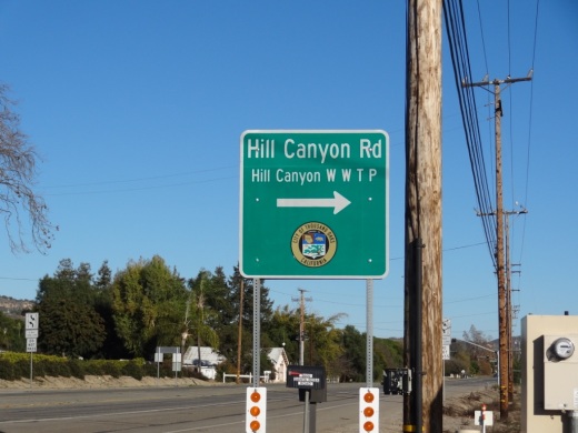
Access the Conejo Canyons bridge via Santa Rosa Road. Coming from Thousand Oaks, take Moorpark Road north down the Norwegian Grade, where it intersects with Santa Rosa Road. Continue about 3.7 miles on Santa Rosa Road and make a left on Hill Canyon Road. Drive down Hill Canyon Road and you will see a large, flat dirt parking area on the right, adjacent to Santa Rosa Valley Regional Park.

Sign on Santa Rosa Road at Hill Canyon (coming from Camarillo)

Sign on Santa Rosa Road at Hill Canyon (coming from Camarillo)

Parking area on Hill Canyon Road, as seen from the Canyon Overlook Trail leading to Lizard Rock.

Parking area on Hill Canyon Road, as seen from the Canyon Overlook Trail leading to Lizard Rock.

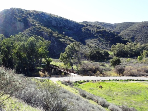
Park and you'll see the Conejo Canyons bridge just south, which takes you to the Hill Canyon Trail, a flat path that after a mile takes you to an intersection. At the intersection, you can turn around, go straight ahead to the Hawk Canyon Trail, take a right turn to the hilly Western Plateau Trail or veer left to make your way to the Arroyo Conejo Trail that ultimately takes you about 2 1/2 miles to the Rancho Conejo Playfields in Newbury Park.

Or go west to the steep Canyon Overlook Trail, a zig zagging hill that takes you to Lizard Rock in Wildwood Park. The hill is a fun challenge with the kids and you'll be rewarded with great panoramic views towards Boney Mountain, Camarillo, Ojai and Simi.

CanyonOverlookTrail.JPG
Conejo Canyons Bridge that takes you to the Hill Canyon Trail

Conejo Canyons Bridge that takes you to the Hill Canyon Trail

LizardRockLoop1.JPG
Conejo Canyons views

Conejo Canyons views

View towards Lizard Rock

View towards Lizard Rock

Libbey Bowl and Libbey Park in Ojai

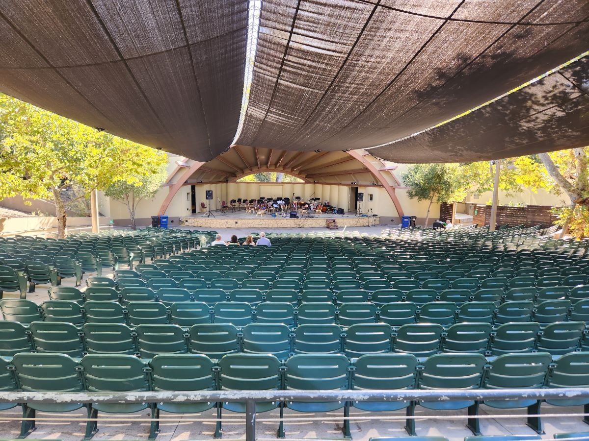
Libbey Bowl and Libbey Park are located in the heart of Ojai near the corner of Ojai Avenue and Signal Street. Libbey Bowl was originally built in 1957 and has been used for the annual Ojai Music Festival, Storytelling Festival, Ojai Day event, holiday celebrations and many other community events through the years. Beginning in 2008, the bowl was renovated and in 2011 was reopened with a new look and design. It accommodates 1,300 people. Learn more about Libbey Bowl at www.libbeybowl.org.

Both Libbey Bowl and Libbey Park are named after Ojai's greatest benefactor, Edward Libbey, a glass manufacturer from Toledo, Ohio. Libbey donated the park to the city in 1917. In front of the park is a shaded pergola along the main "arcade" section of Downtown Ojai.

The park contains a community playground that was designed and built with the help of over 500 volunteers in 2015. It contains a beautiful new play structure and other features that leapfrog what used to be a fairly outdated play area to one of the nicest ones in Ventura County. Visit THIS POST for more information.

This is a photo of the OLD play structure that was replaced in October 2015.

This is a photo of the OLD play structure that was replaced in October 2015.

The new playground!

The new playground!

There are also plenty of benches and seating areas, restrooms, shade trees and tennis courts at Libbey Park. Learn more on the City of Ojai website at www.ojairec.com/460/Libbey-Park.

The Canyon Club - Agoura Hills

Looking for some of the top music acts of the 1970s, 1980s and 1990s nearby in an intimate setting with a great dinner?  Visit the Canyon Club in Agoura Hills!

Tickets vary in price based on the artist and reserved seating requires dinner reservations.  Unreserved seats typically require a two drink minimum.

The dinner menu includes grilled ribeye, filet mignon, salmon, lasagna and more, with a variety of mouth watering starters, salads, sides and desserts. 

Performers have included Kansas, Styx, Cheap Trick, Berlin, Peter Frampton, Blues Traveler, Boys II Men, Hootie and the Blowfish, Pat Benatar, Bonnie Tyler, Don Rickles, Davy Jones of the Monkees, The Smothers Brothers, B-52s, Air Supply, Rick Springfield, John Hiatt, Frankie Valle, Leon Russell, Jonny Lang, Foreigner and more.

Visit wheremusicmeetsthesoul.com/canyon-agoura-hills for schedules, ticket sales, menu and other information. Located at 28912 Roadside Drive, Agoura Hills.

15625.jpeg

One of the most recognizable features of the Canyon Club...the blue star thingys hanging from the ceiling.