Hillside Letters in the Conejo Valley and Greater Ventura County

There are over 500 hillside letters, or “mountain monograms,” in the United States, including 81 in California. What are hillside letters, you ask. They are simply large single letters, abbreviations and sometimes even messages erected on a hillside, usually by a school or town.

The Big “C” overlooking UC Berkeley (From Wikipedia; public domain)

The Big “C” overlooking UC Berkeley (From Wikipedia; public domain)

One well known hillside letter is a giant concrete block letter “C” built in the hills overlooking UC Berkeley that was constructed on March 23, 1905.

We have our share of hillside letters here in the Conejo Valley and Greater Ventura County, some of which you may be aware of…others, perhaps not.

The mountain monograms visible in our neck of the woods include:

The letters CLU on Mt. Clef Ridge above Cal Lutheran University are maintained by students.

Hilltop A overlooking Agoura High School up a steep hill. Made out of wood, I believe.

Here is a view of the letter VC north of Ventura College in late April 2019.

Here is a view of the letter VC north of Ventura College in late April 2019.

If you drive north up Catalina Street, west of Ventura High School, you will be able to see this letter V on the hillside.

The letter F is located in the hills west of Fillmore and is quite easy to see.

This letters SP letters in the hills south of Santa Paula is cleared brush. They originated in 1922. More information on THIS PAGE.

Happy Face Hill in Simi Valley is not a mountain monogram but is perhaps the visible hillside attraction throughout Ventura County.

Ventura County Area Crime Maps Online

The Ventura County Sheriff's Office serves the County of Ventura and five contract cities of Camarillo, Fillmore, Moorpark, Ojai, and Thousand Oaks. There is a wealth of information on the VC Sheriff's website at www.venturasheriff.org, including phone numbers for patrol stations.

One tool available that shows recent crimes in these jurisdictions is located at CrimeMapping.com, a website that provides information, in map format about crimes committed on a rolling 180 day basis.

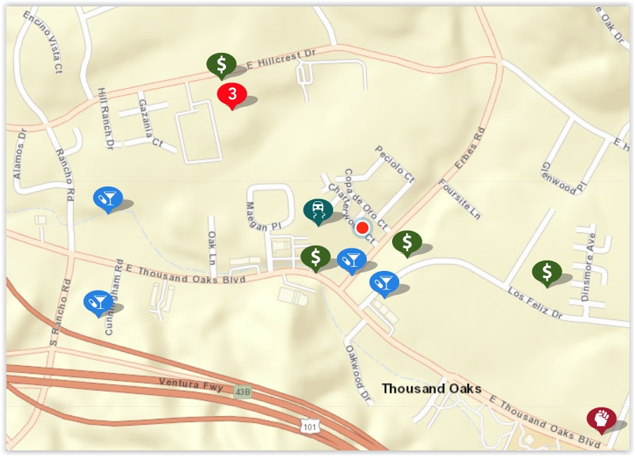
To use CrimeMapping.com, simply go to the site and type in a location - address, landmark or zip code. From there, you’ll see a map of crimes reported over the most recent week, which is the default time frame. You can change this time frame using filters on the site, up to 180 days’ worth of data. Here’s what the map looked like over a 180 day period:

crimemapping map.JPG

You can learn more about individual crimes by clicking the icons on the map. Crimes include arson, assault, burglary, disturbing the peace, drug/alcohol violations, DUI, fraud, homicide, auto theft, robbery, sex crimes, theft/larceny, vandalism, vehicle break-in and weapons.

The number 3 in a red circle in the image above indicates multiple records. I clicked it and there were 2 possession of a controlled substance - one in the 300 block of Hillcrest Drive on July 17th at 1:30pm and the other in the 2400 block of Hillcrest Drive on July 17th at 12:30pm. The third violation was fraudulent use of access card on April 1st at midnight.. Note that exact addresses are not provided; they report as specific as block number.

The first icon at the bottom right side of the image was an assault (battery) in the 2200 block of E. Thousand Oaks Boulevard at 10:05am on August 7th.

You may also create alerts on the CrimeMapping site that are sent to you via email. Click “Receive Alerts,” choose location (city, landmark, address or zip) and search distance (ranges from 500 feet to 2 miles).

The Fillmore State Fish Hatchery Is a Fun Place to Visit With the Kids

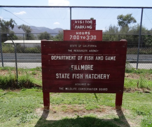
FillmoreFishHatchery_Sign.jpg

Hours are now 8 a.m. to 2 p.m.

The Fillmore Fish Hatchery was dedicated as a state hatchery in 1932. It is one of 21 hatcheries operated by the California Department of Fish and Game (DFG). The Fillmore Hatchery produces about 1 million rainbow trout, or about 400,000 lbs of fish, each year.

Fertile trout eggs are shipped to Fillmore from DFG broodstock hatcheries at Mount Whitney and Hot Creek, located in the eastern High Sierra. The fish are stocked in southern California lakes, reservoirs and streams accessible to the public for fishing. The hatchery operates year-round, 365 days a year. Through selective breeding, DFG has developed strains of rainbow trout that spawn during different months of the year.

FillmoreFishHatchery_fish2.JPG

There is netting over the pond to keep birds from pilfering the fish (before the netting they nabbed as much as 30% of the fish each year). The hatchery is run using funds raised from fishing licenses and taxes on sporting equipment.

Kids and parents alike will be wowed by the number of fish in the hatchery.

Kids and parents alike will be wowed by the number of fish in the hatchery.

The hatchery is located off Highway 126, about a mile east of downtown Fillmore. It is open 365 days a year, from 8 a.m. to 2 p.m. It is quite a fun place to bring the kids for a brief encounter with thousands of hungry fishies. 

Fish feed is provided for free to the public in limited supply. Feed machines are filled no more than at 8 am and noon daily. 

City of Fillmore Neon-Lighted Sign From Pre-World War II

You don't see many signs around town like the Fillmore sign at the northeast corner of Highway 126 (E. Telegraph Road) and Central Avenue.

Fillmore sign photo taken as I was waiting at the stoplight driving south on Central Avenue.

Fillmore sign photo taken as I was waiting at the stoplight driving south on Central Avenue.

The sign was originally constructed in 1940, making it 80 years old. It is designated a historical landmark by the City of Fillmore.

The Fillmore sign is a cool green neon lit up at night

The Fillmore sign is a cool green neon lit up at night

It's not exactly easy getting to Fillmore from the Conejo Valley as you either have to take the winding path of the 23/Grimes Canyon Road via Moorpark or drive out to Ventura via the 101 and take the 126 to Fillmore by way of Santa Paula. Kind of a haul but certainly fun to do every now and then.

At a total area of only 2.8 square miles, Fillmore is the smallest of Ventura County's 10 cities, and its population of roughly 16,000 places it 9th (roughly double the population of Ojai). Fillmore was not named after Millard Fillmore; it was named after Jerome Fillmore, General Superintendent of the Southern Pacific Railroad when they built the line connecting Santa Paula, Fillmore and Castaic.

Quite a quaint little place that is certainly fun to visit, with highlights such as numerous themed train rides at Fillmore & Western Railway, State Fish Hatchery and Railroad Visitor Center, along with an old town feel along Central Avenue.

Fillmore sign as of July 2022

Sweeten Your Day with a Visit to Bennett's Honey Tasting Room in Fillmore

We were in the Santa Clarita area ready to head back home to the Conejo Valley, when I decided, how about if we take Highway 126 for once. So we did.

Highway126_CountyLine.JPG

It was a leisurely drive on a late Sunday morning, when we came across a sign that caught my interest.

HoneyTastingRoom.JPG

After passing the sign, I asked my son if he would like to do some honey tasting, to which he replied, "SURE!" So we turned back!

Bennett's Honey Tasting Room is located just north of Highway 126 at 3176 Honey Lane in Fillmore. It feels really off the beaten path, but is just 5 miles east of central Fillmore.

BennettsHoneyFarm_building.JPG

There's a small parking lot in front of the retail store. We walked up the steps, opened the door, and found ourselves in a small, one room shop, where we were greeted by smiling staff and stacks of honey jars and products.

BennettsBest_shop.JPG

But what really caught our eye, the reason for our stopping by on this mild, Sunday morning, was the honey tasting kiosk in the middle of the room. We treated ourselves to samples of honey derived from orange blossoms, sage, wildflowers, buckwheat, avocado, clover, eucalyptus and cactus. Honey heaven!

BennettsBest_tasting.JPG

How is honey made? Worker bees suck nectar from a blossom and carry it back to the hive in their honey sacs (i.e. stomachs). On its way home, acid secretions in the sacs start changing the nectar to honey. In the hive, the honey is passed to a receiving bee where it is processed and concentrated for storage in empty honeycomb cells. 70,000 nectar "loads" become one pound of honey. Housekeeping bees "dry" the honey by fanning their wings in unison, then the cells are sealed for beeswax. Honey will keep for years.

Bennetts_honeycomb.JPG

My top choice was the cactus flavored honey as well as the "creamed" honey. We inquired about a honey that would be best for combating pollen allergies, and were told the wildflower honey was the best bet. And then we asked about the raw honeycomb shown above.

We were immediately offered a sample of the honeycomb. Heck, why not! Are we supposed to eat the wax comb? Some people do, but most swallow the tasty honey and spit out the wax.  The honeycomb was a delicious treat and we bought one of those too!

Bennett's Honey Farm was founded by Red and Ann Bennett and is currently owned by Chip and Taydee Vannoy. They produce their own honey right here in Ventura County under brands "Topanga Quality Honey" (found at Whole Foods and other specialty markets) and "Piru Canyon Honey" found at farmers' market and fruit stands in local counties.

To learn more, visit www.bennetthoney.com or call 805.521.1375.

2013 Amgen Tour of California Route Passes Through Ventura County on May 15th

2013 Amgen Tour of California Route Announced

For the First Time, America’s Greatest Cycling Race Will Travel South to North, Beginning in Escondido and Crossing Beaches, Deserts, Mountains, Golden Gate Bridge

Changing direction for the first time in its eight-year history from south to north, America’s largest and most prestigious professional cycling stage race, the 2013 Amgen Tour of California, will bring riders and spectators first-time destinations, unprecedented climbs and demanding sprints on the approximately 750-mile course.

Amgen returns as the title sponsor for the heralded 8-stage race, set for May 12 to 19, 2013. Beginning with a circuit in Escondido, the route will run through 13 official host cities and include a first-time finish at the top of Mount Diablo, the 3,864-foot peak in the San Francisco Bay area. The race’s last stage will begin along the San Francisco Bay and continue across the Golden Gate Bridge, where a rolling traffic break will give cyclists uninterrupted access for the six-minute crossing.

Two new cities join the race route roster: Greater Palm Springs and Murrieta will host Stage 2, which will include an intense finish up the Palm Springs Aerial Tramway, one of the toughest climbs anywhere with an 1,880-foot elevation gain in the last four miles. Two other firsts: Escondido and Santa Rosa will become the first cities in race history to have hosted both an overall start and an overall finish.

As one of the most anticipated professional cycling races on the international calendar, the Amgen Tour of California draws top cyclists from the ranks of Olympic medalists, Tour de France competitors and world champions including BMC Racing Team’s current world road champion Philippe Gilbert.

The 2013 Amgen Tour of California will feature the following highlights (route and start times are subject to change):

Stage 1: Sunday, May 12, 11:15 am start – Escondido, Stage Length 104.3 miles

Stage 2: Monday, May 13, 10:20 am start – Murrieta to Greater Palm Springs (126.1 miles) 

Stage 3: Tuesday, May 14 11:20 am start – Palmdale to Santa Clarita (Finishes at Magic Mountain Parkway) (111.8 miles) 

Stage 4: Wednesday, May 15 12:35 pm start – Santa Clarita to Santa Barbara (84.7 miles)

Stage 4 is largely through Ventura Co

Read More