The Old "Agoura" Sign on Agoura Road
/
I was running (literally running) around Agoura Hills, in the vicinity of Agoura Road west of Chesebro Road, when I looked up and saw this distinctly vintage "Agoura" sign displayed at the corner of Agoura and Lewis Roads. While I've driven that stretch of Agoura Road hundreds of times over the years, for whatever reason I never really noticed this interesting sign.

I wondered how long this sign has been there. City of Agoura Historian Cim Castellon was able to help put some of the puzzle together by contacting Brian Rooney of R7 Media, who provided the image below.
This photo shows two women posing for the camera with the Agoura sign and Agoura Market and Gas Station, owned by Harold Neale, in the background.
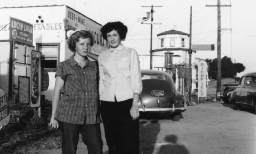
Photo Credit: R7 Media (www.r7media.com)
On the east side of Lewis Road road is the old Agoura Post Office at 28249 Agoura Road, Agoura Hills. Brian thinks the Agoura sign was put up about the time the post office opened.

The former center Stage Music building that closed in 2017 and was demolished in early 2022.
The sign is located adjacent to what used to be Center Stage Music, in a building that originally was Fitzgerald's Market in the 1920s and later Agoura Market in the 1940s. This building was demolished in 2022.
For more local history, be sure to stop by the Reyes Adobe Historical Site, the first home built in Agoura Hills back in 1850.